|
Cyprus has long been an offshore home for Russian assets. Now, Cyprus is becoming a home for Russians themselves. Because of its membership in the EU and its liberal visa and immigration policies, Cyprus is seeing a major influx of Russian tech workers, in particular. According to some who left Russia, entire IT industries, like game design, have left Russia since February, despite the Russian government's attempts to keep IT workers in the country with discounted mortgages and military deferrals. Russians are not the only ones arriving in Cyprus, though; at least 16,000 Ukrainians have also arrived in Cyprus since February, contributing to domestic political tensions in Cyprus, which is supporting EU sanctions on Russia despite its long reliance on Russian money and Russian tourism. www.washingtonpost.com/world/2022/10/23/cyprus-russian-expat-tech-workers/
0 Comments
Natural gas prices are 8x higher than normal in Europe, and most countries are desperate to obtain and store enough natural gas to get them through the winter, but although liquified natural gas (LNG) deliveries are arriving, the capacity to regasify the LNG is maxed out. This map from Reuters shows more than 35 LNG ships waiting in the Atlantic and Mediterranean to offload their cargo at Spanish LNG terminals: graphics.reuters.com/EUROPE-ENERGY/LNG/dwvkroxdgpm/Congestion%20at%20Spain%20LNG%20Terminals.jpg (Map from www.reuters.com/business/energy/dozens-lng-laden-ships-queue-off-europes-coasts-unable-unload-2022-10-17/.)
Partitioned from the rest of the island when Ireland (the country) was granted independence in 1921, Northern Ireland, which is part of the UK, is the historically Protestant-majority northeastern section of Ireland (the island). However, a recent census shows that Catholics now outnumber Protestants in Northern Ireland for the first time. www.nytimes.com/2022/09/22/world/europe/northern-ireland-census-catholics-protestants.html
Western Europe is one of the world's most rapidly aging regions. This geo-graphic looks at the anticipated increase in dementia rates by 2050 in a sampling of Western European countries: cdn.statcdn.com/Infographic/images/normal/28310.jpeg
The fight for eastern Ukraine is not just about land or population or territorial integrity. It is also about Ukraine's mineral wealth, a disproportionate share of which lies east of the Dnieper River, as these maps show. (Maps from www.washingtonpost.com/world/2022/08/10/ukraine-russia-energy-mineral-wealth/.)
This geo-graphic compares per capita spending on pharmaceuticals in the U.S. to that in a sampling of peer-group (OECD) countries: www.statista.com/chart/3967/which-countries-pay-the-most-for-medicinal-drugs
Liquifying natural gas is a more expensive, energy-intense alternative to pipelines in the delivery of natural gas. Several European countries are trying to bring more liquified natural gas (LNG) capacity online as quickly as possible to replace Russian, pipeline-delivered gas. This geo-graphic from Statista looks at which countries are currently the biggest suppliers of LNG: www.statista.com/chart/27839/biggest-liquefied-natural-gas-exporters
Because inexpensive armed drones, including Turkey's TB2 drones, proved decisive in the 2020 conflict between Armenia and Azerbaijan, other countries have been looking to add them to their arsenals. This map, from ProPublica, shows which countries have used TB2s, purchased TB2s, or are trying to purchase TB2s: assets-c3.propublica.org/images/articles/Screen-Shot-2022-07-15-at-5.48.51-PM.png
In 2021, the European Union exported 33 million tonnes of waste to non-EU countries, a 77% increase in exported waste since 2004. Where did it go? This geo-graphic from Statista shows the top eight destinations for EU waste in 2021: cdn.statcdn.com/Infographic/images/normal/24716.jpeg (China which, as recently as 2009 received more than 10 million tonnes of EU waste, now takes virtually none.)
Soil composition is a vital but often-neglected component of physical and biogeography. Like the American Midwest, Ukraine and southern Russia have some of the world's most productive soil, called chernozem (in Eurasia and Canada) or mollisol (in the U.S). This article from Science News looks at ways in which war has a lasting impact on the underlying soil chemistry, hydrology, structure, and physical composition: www.sciencenews.org/article/ukraine-russia-war-soil-agriculture-crops. (For a map that shows soil types around the world, check out this one from the USDA: https://www.nrcs.usda.gov/wps/portal/nrcs/detail/soils/use/?cid=nrcs142p2_054013.)
Russian President Vladimir Putin recently compared himself to Czar Peter the Great, who waged war against neighbors to "reclaim" Russian lands. This map from Statista compares the borders of Russia today with the borders of the Russian empire at the beginning of WWI: cdn.statcdn.com/Infographic/images/normal/27605.jpeg
Historically, the Ukrainian Orthodox Church was considered an autonomous subordinate of the Russian Orthodox Church. In 2018, the Ecumenical Patriarchate of Constantinople (long considered first among equals in the Eastern Orthodox Church) announced its intention to grant autoencephaly (religious independence) to the Ukrainian Orthodox Church at some point in the future, causing the Russian Orthodox Church to sever communion with Constantinople. In January 2019, after intense opposition by Russia, which reportedly included involvement of Russian security services operating in Ukraine, various factions of the Ukrainian Orthodox community agreed to unification, and the Ukrainian Orthodox Church was granted autoencephaly by Constantinople shortly thereafter. Since then, more than 2,000 Ukrainian parishes have switched from the Ukrainian Orthodox Church of the Moscow Patriarchate (UOC-MP) to the newly unified and independent Ukrainian Orthodox Church. This map, created by a Reddit user 5 years ago, hints at the complexity of Orthodox Christianity in Europe and the Mediterranean. preview.redd.it/y2s27pd5oobz.png?width=960&crop=smart&auto=webp&s=cd386b0ae22f56b311ce36bfa4000926bf6f70d1
The war in Ukraine is bottling up wheat exports and, especially in the southern and eastern parts of the country, damaging winter wheat fields planted last fall and interfering with spring planting. This geo-graphic from Statista highlights the countries most dependent on Ukrainian and Russian wheat: www.statista.com/chart/27181/least-developed-countries-dependent-on-wheat-from-russia-ukraine
Tomorrow, French voters will go to the polls to choose between current president Emmanuel Macron and perennial far-right challenger Marine Le Pen. This geo-graphic from Statista shows where right-wing populist parties have had the most electoral success in Europe: www.statista.com/chart/20094/national-election-success-of-far-right-parties-europe (For those who cannot make out the flags to the left of the bars, the top three countries shown are Hungary, Poland, and Switzerland.)
Maps are powerful and easily understood vehicles for conveying geographic information. This excellent article from Geographical (UK) looks at the some of the less-obvious issues that data visualization professionals are needing to consider as they prepare maps about the war in Ukraine, from color choices to spatial precision to arrows or no arrows and more. geographical.co.uk/places/mapping/item/4316-mapping-ukraine
Where are Ukrainians taking refuge? For now, primarily in neighboring countries. Poland has taken in more than half of the roughly 4 million people who have left Ukraine. This map (like last Thursday's geo-graphic) is from Statista based on data from the UN High Commissioner on Refugees: cdn.statcdn.com/Infographic/images/normal/26960.jpeg
As of late last month, an estimated 4 million people had left Ukraine, 9% of the population. This geo-graphic from Statista, based on data from the UN High Commissioner on Refugees, puts Ukraine in the context of previous refugee crises since 1960: www.statista.com/chart/27151/largest-refugee-crises-since-1960-by-peak-number-of-refugees
Not surprisingly, Russia has become the most sanctioned country in the world, with nearly 6,000 different sanctions targeting individuals and/or governmental entities. This geo-graphic from Statista looks at the countries with the most international sanctions. cdn.statcdn.com/Infographic/images/normal/27015.jpeg
Tulips, as both bulbs and cut flowers, are strongly associated with the Netherlands. But the Netherlands' dominance in floriculture extends far beyond tulips. In fact, the Aalsmeer Flower Market, southwest of Amsterdam, oversees the distribution of 43 million cut flowers every day! Flowers are flown into Aalsmeer from all over the world, sorted, graded, auctioned, and rapidly distributed across Europe. The building in which the flower auction is held is the fourth largest building in the world by footprint, roughly the size of 200 soccer fields. www.visitaalsmeer.nl/wp-content/uploads/2021/06/RoyalHolland-Flower-Auction-Aalsmeer-1-1920x1440.jpg
The impact of even fairly conventional warfare can be long lived from a biogeographic perspective. A 460-square-mile area of northeastern France was so badly contaminated by shelling during WWI that shortly after the war the French government cordoned it off as the Zone Rouge, or Red Zone, an area deemed unfit for agriculture or human habitation. Even today, more than a century later, there are untold numbers of unexploded shells, including gas canisters, in the Zone Rouge and enough arsenic in the soil to kill 99% of plant life. www.atlasobscura.com/places/zone-rouge
Climate Central is a US-based nonprofit using science, big data, and proprietary machine-learning mapping to identify coastal areas likely to be underwater or subject to frequent flooding by 2050. According to Climate Central's interactive map, hard-hit areas in Ireland are likely to be Dublin's waterfront and sections of southwestern Ireland, including Shannon's airport and parts of Limerick and County Clare. coastal.climatecentral.org/ 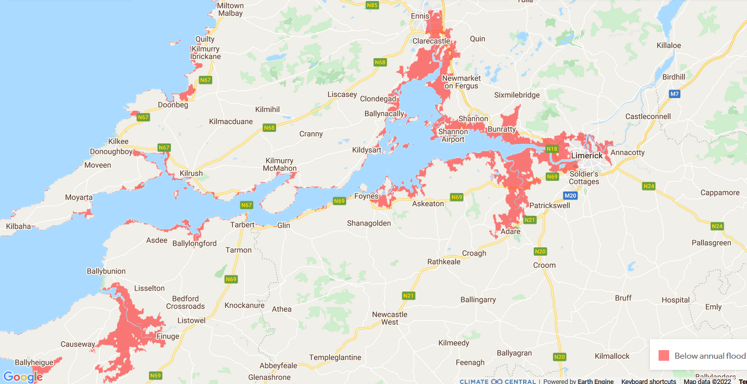 War is bad for landscapes and cultural preservation. Ukraine has 7 sites that have been designated as UNESCO World Heritage Sites and another 17 sites that are on a tentative list for prospective inclusion. To find out more about each of these sites, you can click on the site names or locations on this interactive UNESCO map: whc.unesco.org/en/statesparties/UA
The Sea of Azov, at the far northeastern end of the Black Sea (and the Atlantic Ocean) has been in the news recently. Situated east of the Crimean Peninsula, the Sea of Azov is the shallowest of the world's seas, with a depth that does not exceed 46 feet. Historically, the sea was known for its rich fishing. Although Russia and Ukraine agreed to share the Sea of Azov in a 2003 treaty, today the sea is all but encircled by Russian military forces. The besieged Ukrainian port city of Mariupol sits on the northern shore of the Sea of Azov, as shown on this map from the geopolitical consulting firm Stratfor: www.stratfor.com/sites/default/files/styles/wv_small/public/ukraine-navy-sea-of-azov-092418_0.png.
The maps and analysis in this BBC article might help those who are looking for resources to discuss Russia's invasion of Ukraine with their kids. (BBC News is also a reputable source to follow on this topic from a non-U.S. perspective.) https://www.bbc.com/news/world-europe-56720589
Modern Ukraine's language geography reflects czarist and Stalinist policies of Russification in Ukraine -- deporting ethnic Ukrainians and Tatars for perceived disloyalty and giving land to ethnic Russians -- as well as more recent Russian incursions into what is labeled on this map as "separatist-controlled areas." (Map from www.washingtonpost.com/world/2022/01/21/ukraine-russia-explain-maps/.)
|
Blog sharing news about geography, philosophy, world affairs, and outside-the-box learning
Archives
December 2023
Categories
All
|
 RSS Feed