|
And therein lies the rub: just days after the UN Intergovernmental Panel on Climate Change releases its bleak report on global warming, the Biden White House asks the OPEC+ group to pump more oil to bring down gasoline prices, which are at or near a seven-year high. OPEC+ refers to the official members of the Organization of Petroleum Exporting Countries, shown in dark blue on this map, and other major petroleum producers who often coordinate with OPEC but are not members of OPEC, shown in light blue on this map. www.insightsonindia.com/wp-content/uploads/2020/03/Break_through.png
0 Comments
Just days ago, with the Tokyo Olympics underway, the site of the original Olympic games, Olympia, Greece, was evacuated due to wildfires. Intense wildfires are also raging across multiple locations in Turkey, Italy, and elsewhere around the Mediterranean. In fact, over the last two weeks all of the countries shown in red on this map have experienced serious wildfires, many of which are still burning. 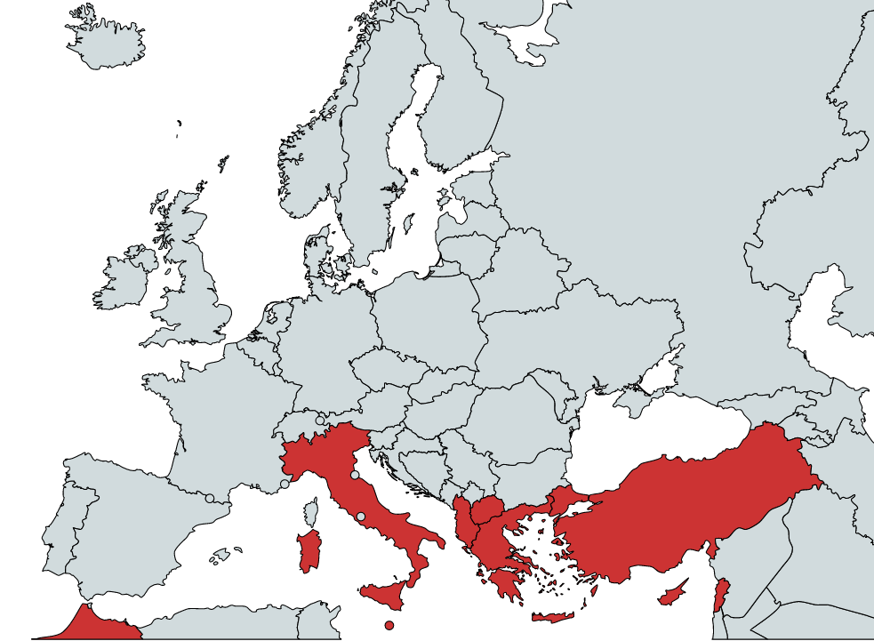 Threatening Europe with refugees appears to be a new favorite ploy in international relations. Turkey has been using this tactic for more than five years, primarily focused on keeping Syrian refugees in Turkey in exchange for money and various other EU considerations. In May, Morocco allowed illegal migrants, primarily from Sub-Saharan Africa, to "escape" into adjacent Spanish territory to show displeasure with Spain's decision to provide medical treatment for a leader of Western Sahara's Polisario Front. Now Egypt is suggesting Europe may be faced with a flood of refugees (including "youth joining terrorist groups") if European countries do not side with Egypt in its dispute with Ethiopia over the filling of the Grand Ethiopian Renaissance Dam on a section of the Blue Nile in northwestern Ethiopia. www.al-monitor.com/originals/2021/07/egypt-warns-europe-against-illegal-immigration-amid-nile-dam-impasse
Since the beginning of the civil war in neighboring Syria 10 years ago, Lebanon has hosted the largest number of externally displaced people on a per-capita basis. At one point, as many as one in four people in Lebanon were Syrian refugees. In 2020, the island of Aruba (technically part of the Netherlands) supplanted Lebanon as the host of the greatest per-capita number of externally displaced people, most of whom have fled nearby Venezuela. This geo-graphic, based on UN data, shows the eight countries hosting the most externally displaced people on a per-capita basis: www.statista.com/chart/3576/the-countries-with-the-most-refugees-per-capita
This map, based on satellite imagery, shows the geography of recent Israeli airstrikes in Gaza. The more urban northern part of Gaza, in and around Gaza City, shows the most destruction of buildings (389 building destroyed or severely damaged, in red, and 157 moderately damaged buildings, in orange). The more rural southern part of Gaza mostly shows impact craters in fields near the border with Israel, in gray. (Map from www.washingtonpost.com/world/2021/06/11/gaza-damage-map-rebuilding-israel/.)
This chart looks at casualties over the last 13 years resulting from conflict between Israel and the West Bank/Gaza: www.statista.com/chart/16516/israeli-palestinian-casualties-by-in-gaza-and-the-west-bank
Dam projects around the world are sources of geopolitical conflict and intrigue. A dramatic drop in the quantity of water carried by the Euphrates River from Turkey into Syria is the latest to generate outrage, but, as with so much in Syria, it's complicated:
"The Euphrates River in Syria separates between the lands under the control of the Syrian government and the territories held by the Kurdish-led Syrian Democratic Forces (SDF). The Syrian government controls the areas located south of the Euphrates and overlooking its right bank, including the areas extending to the southern countryside of the provinces of Raqqa, Deir ez-Zor and Manbij in the countryside of Aleppo. ... The SDF, meanwhile, controls the left bank of the river, which is seen as its first point of control that spans the areas of northeastern Syria, including the northern countryside of the provinces of Raqqa and Deir ez-Zor. The Free Syrian Army (FSA), backed by Turkey, controls the right bank of the Euphrates over a distance of no more than 6 kilometers into Syrian territories near Jarablus. Both the Syrian government and the SDF accuse Turkey of the dramatic drop in the levels of water flowing into the Euphrates River. The Syrian opposition, however, has remained mum, as it does not benefit from the river’s water. During a tour to check on the water situation at the Euphrates River on May 7, the Syrian government's Minister of Water Resources Tamam Raad called on Turkey to release water into the river according to Syria's and Iraq's fair share. He also urged the international community and international organizations to intervene in this regard." https://www.al-monitor.com/originals/2021/05/syrian-government-calls-turkey-release-euphrates-water#ixzz6uuBj24da This geo-graphic shows the world's biggest sovereign wealth funds (i.e., state-owned investment funds), by asset value as of January. (GIC Private Limited and Temasek Holdings are both Singaporean; together they would move Singapore into the #3 position.) Norway's sovereign wealth fund, the world's largest, is derived largely from its offshore oil reserves in the North Sea. It was established in 1990 "to invest government revenues from fossil fuel industries into sectors deemed more sustainable in order to provide for a future when the country can no longer rely on its income from oil" and helps give Norwegians one of Europe's highest median disposable incomes. www.statista.com/chart/24060/the-worlds-biggest-sovereign-wealth-funds
A recent report from the British nonprofit Save the Children finds that approximately one out of every six children on earth is living in a conflict zone, and "165 million of these children are affected by high intensity conflicts." This map shows the areas with the largest numbers of children living in conflict zones, including Honduras, with a total population of fewer than 10 million. For the complete report, see www.savethechildren.org.uk/content/dam/global/reports/education-and-child-protection/war_on_children-web.pdf
Elections and wars are inflection points rich in counterfactuals. The series of maps in this BBC Future article considers alternate histories, which have become a field of serious historical scholarship: what if the U.S. had lost the American Revolution? what if WWII hadn't been fought? what if the states of the United States had splintered in line with some actual proposals? www.bbc.com/future/article/20201104-the-intriguing-maps-that-reveal-alternate-histories
Mike Lee, the senior U.S. senator from Utah, tweeted recently, "Democracy isn't the objective; liberty, peace, and prospefity are." (He meant "prosperity," obviously.) It's not clear if most Americans would agree with Lee, but Arab youth would. The results of the 2020 Arab Youth Survey were released recently and found, among other things, more Arab youth (ages 18-24) would prefer to live in the UAE, a monarchy, than anywhere else; China and Russia are both seen as much stronger allies of Arab youth than the U.S. is (73% and 71% vs. 56%); and Arab youth want good governance and economic opportunity but are not interested in any particular political "-ism." For more details, see www.al-monitor.com/pulse/originals/2020/10/arab-youth-future-gulf-us-gaining-ground-russia-china-allies.html or www.arabyouthsurvey.com/pdf/downloadwhitepaper/AYS%202020-WP_ENG_0510_Single-Final.pdf
Create art, experiment with geometry, and learn a bit of cultural geography while using this very online cool mosaic tile simulator from the Qatar Foundation International. (Here is a tile pattern I made :-) tilemaker.teachalmasdar.com/tile?68157) tilemaker.teachalmasdar.com/  This map, from Storygardenz, attempts to place some of the Western world's most famous stories in their geographical context (from www.storygardenz.com/about).
Recent shipping-related disasters in Beirut and Mauritius are generating calls for the UN to intervene on behalf of a floating oil storage tanker anchored outside Yemen's largest port, Hodeidah. The 44-year-old single-hulled tanker, carrying more than 1 million gallons of crude oil, was effectively abandoned in 2015 during Yemen's civil war when Houthi rebels took control of Hodeidah, on Yemen's Red Sea coast. The Houthis and the government both claim the tanker, carrying perhaps $80 million worth of oil. After the ship's engine room began taking on water earlier this year, a temporary fix was applied, but without further maintenance the ship has been characterized as a "time bomb," at risk of exploding or sinking, either of which would be devastating for Hodeidah and for Yemen, which imports nearly all of its food. www.maritime-executive.com/article/outcry-grows-after-beirut-and-mauritius-for-action-on-yemen-oil-tanker
The U.S. National Oceanic and Atmospheric Administration recently, and unexpectedly, issued notice that satellite imagery of Israel and the Occupied Territories will no longer be blurred out. This article from Foreign Policy looks at the background of the policy change and its implications for human rights, archaeology, science, technology, civil society, and more.
"For the past two decades, there has been a general—and mostly unchallenged—understanding that satellite imagery is restricted over Israel and the Palestinian and Syrian territories it occupies. This was due to a 1996 U.S. regulation known as the Kyl-Bingaman Amendment (KBA) which has limited the quality and availability of high-resolution satellite imagery produced by U.S. companies covering Israel (and by implicit extension, the occupied Palestinian territories and the occupied Golan Heights). The result is that publicly available imagery on platforms such as Google Earth has been deliberately coarse and blurred. On June 25, following two years of sustained pressure from academia and civil society, the 97-word KBA was unexpectedly reformed, making higher-resolution satellite imagery legally accessible and readily available to all. ... Israel, driven by a desire for Cold War secrecy, lobbied Congress for stricter regulation, which led to the passing of the KBA: the U.S. government’s only censorship of imagery of any part of the world. The legislation, implemented under the guise of protecting Israel’s national security, was actually more an act of censorship. After all, high-resolution satellite imagery allows researchers to understand, identify, and document landscape changes. ... For 24 years, the legislation obfuscated the damaging effects of the Israeli occupation by literally hiding them from view. The censorship over Israel and the occupied territories has had negative archeological, geographical, and humanitarian implications. Arguably the most glaring of these has been its effects on monitoring the decades long Israeli occupation—including documenting home demolitions, territorial disputes, and settlement growth. Lower-resolution imagery has forestalled efforts to challenge and verify human rights violations, especially in hard-to-reach areas such as the Gaza Strip...." foreignpolicy.com/2020/08/03/israel-cant-hide-evidence-of-its-occupation-anymore Talks have broken down, again, between Ethiopia and Egypt over Ethiopia's Grand Renaissance Dam project. The Blue Nile, which begins in Ethiopia, contributes 80% of the Nile River's water. For Egypt, the waters of the Nile are essential for the economic and literal life of the country. For Ethiopia, the Grand Renaissance Dam and the electricity it will generate are a matter of national pride and economic progress. This article from Al Monitor does a good job laying out the geopolitical issues: https://www.al-monitor.com/pulse/originals/2020/07/egypt-ethiopia-nile-dam-dispute-diplomacy-africa-union-trump.html#ixzz6ShPs0mSZ
Coral bleaching occurs when unusually warm water temperatures lead to coral polyps' eviction of their symbiotic algae. But some of the world's most spectacular coral reefs are located in the hot, saline waters of the Red Sea and Persian Gulf. Scientists based in the UAE are studying local reef ecology to try to understand how corals and other fauna can withstand the extreme conditions. www.al-monitor.com/pulse/originals/2020/06/united-arab-emirates-coral-reef-fauna-climate-change.html
COVID-19 has cratered Egypt's tourist industry. But even in good times few tourists stray far from the sites along the Nile River. After all, deserts stretch in both directions from the Nile. The desert landscape is not just sand dunes, though. For example, 6 hours southwest of Cairo in the Western Desert, in Egypt's Farafra Depression, one can visit the other-worldly chalk formations of White Desert National Park featured in this article from Atlas Obscura: www.atlasobscura.com/places/white-desert
Spoken Arabic varies widely across the Arabic-speaking world, with some dialects all but unintelligible to each other. This Reddit map shows the dominant Arabic dialects across North Africa and the Middle East.
www.reddit.com/r/MapPorn/comments/extcfh/map_of_different_arabic_dialects_from_the_arab/ The Trump Administration recently suspended visas for citizens from six additional countries: Eritrea, Kyrgyzstan, Myanmar, Nigeria, Sudan, and Tanzania. All of the countries highlighted on this map are now subject to travel "bans" of one kind or another. The countries in green are predominantly Muslim; the countries in yellow are not. (Nigeria has a Muslim majority with a large Christian minority; Tanzania has a Christian majority with a large Muslim minority.) 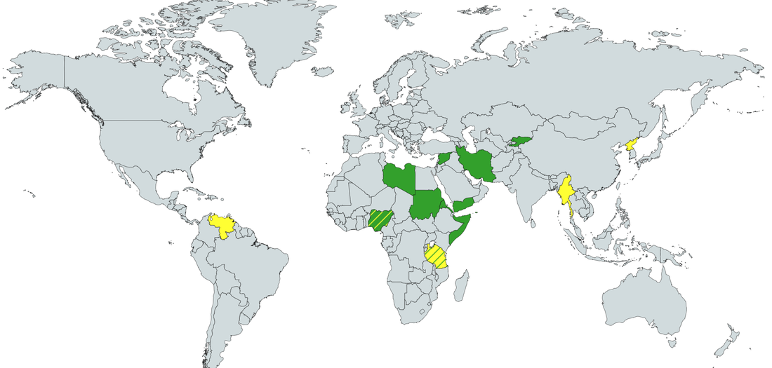 Desert locusts are endemic to Africa, the Middle East, and parts of Asia, but after years of drought followed by heavy rains and warmer temperatures in 2019, East Africa is now contending with its worst locust infestation in decades. Billions of the insects, some in swarms "so thick [that people] can barely see through them," are chewing their way through every bit of vegetation in their paths. If they are not checked by aerial spraying before the spring planting season begins in March, they will devastate young crops and could touch off massive food security issues across East Africa later this year. According to the UN's Food and Agriculture Organization (FAO), which is trying to organize assistance to combat the locusts, Ethiopia and Somalia haven't seen an invasion of this size in 25 years and for other countries in the region it's been longer still: at least 50 years for Uganda and 70 years for Kenya. (The median age in the region is about 19.) www.dw.com/en/locust-plague-east-africa-destructive-food/a-52165354
President Donald Trump's recent threat to target Iranian cultural sites raises the question, "What are Iran's cultural sites?" This interactive site allows users to view and learn about Iran's 22 cultural and two natural UNESCO World Heritage Sites, including Persepolis, the Golestan Palace, and the Sheikh Lotfollah mosque built by Shah Abbas in Esfahan: whc.unesco.org/en/statesparties/ir
For those interested in expanding their understanding of Israel and Palestine, a handful of tour operators are taking tourists beyond Jerusalem and Tel Aviv to harvest olives in a Palestinian village, share a Shabbat meal in an Israeli settlement on the West Bank, meet artists in Ramallah, view the Gaza Strip from Israel, and otherwise meet the people living in the region and see the Israeli-Palestinian issue up close for themselves. "Aziz Abu Sara, a Palestinian from East Jerusalem who founded Mejdi Tours 10 years ago, told Al-Monitor ... 'Tourists want to see more than just the required sites. They also want to learn about real life in the places they visit,' he said. 'It is impossible to understand the challenges of the people living here without talking to them and getting to know them. There used to be no companies that offered things like that. We were the first company to offer tours based on the two narratives. Our groups always have a Palestinian guide and an Israeli guide. People laughed at us at first and said that no one would come. But then we started to work with an large variety of groups, ranging from educational groups to tourists looking for exclusive tours. What they all had in common was a desire to understand what is really happening in Israel and [Palestine].'" www.al-monitor.com/pulse/originals/2019/10/israel-west-bank-rashida-tlaib-tourism-birth-right-project.html
According to recent data compiled by the OECD, a quarter of doctors practicing in the U.S. received their first medical degree somewhere other than the U.S. This geo-graphic compares the prevalence of foreign-trained doctors across various OECD countries: www.statista.com/chart/3849/the-countries-with-the-most-foreign-trained-doctors/
With Saudi Arabia's state-owned oil company, Saudi Aramco, heading for an initial public offering (IPO) it seemed timely to share this set of maps from Visual Capitalist, detailing the world's biggest oil discoveries since 1868. www.visualcapitalist.com/map-worlds-biggest-oil-discoveries-since-1868/
|
Blog sharing news about geography, philosophy, world affairs, and outside-the-box learning
Archives
December 2023
Categories
All
|
 RSS Feed