|
This map shows regional control of territory within Syria prior to this week's offensive by Turkish forces into the Kurdish-held region in the northeastern part of the country.
infographic.statista.com/normal/chartoftheday_19580_territory_controlled_by_faction_in_syria_n.jpg
0 Comments
Last weekend's attack on a Saudi oil facility sent global oil prices higher, but which countries are most dependent on Saudi oil? This map, based on 2017 OEC data, shows the top four destinations for Saudi petroleum products: China ($29.1B), Japan ($25B), India ($19.4B), and South Korea ($17.7B). China and Japan both import roughly 50% more Saudi oil than does the U.S., which is the 5th biggest importer of Saudi oil ($17.3B). 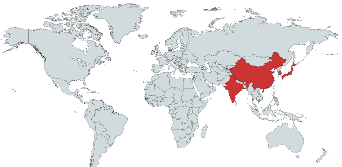 The yellow dots on this map, which accompanied a recent Reuters (UK) story, show the position of oil and liquified natural gas tankers during the week of June 12-19. The narrow body of water in the boxed area between Oman's Musandam exclave (to the south) and Iran (to the north) is the strategically important Strait of Hormuz. graphics.reuters.com/MIDEAST-ATTACKS-HORMUZ/0100B04806Y/index.html 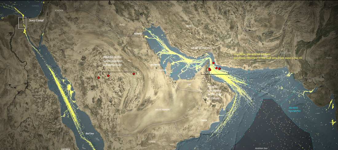 Why does a Saudi company own land in California, Arizona, and other places around the world? The answer lies in advantageous local water rights and the need to provide fodder for a dairy industry in a desert. www.theguardian.com/us-news/2019/mar/25/california-water-drought-scarce-saudi-arabia
This map highlights where Arabic is spoken as the primary or secondary language: www.reddit.com/r/MapPorn/comments/bhim2x/the_arabic_speaking_world_1280772/
After the recent visit of Egyptian President Sisi, the Trump Administration is looking into declaring the Muslim Brotherhood a terrorist organization. However, in addition to having been the best-organized political opposition in Egypt prior to being banned by Sisi's government in 2013, the Muslim Brotherhood is a diverse organization operating in many countries and having a variety of political and social goals. This map, from Al Monitor, shows the status of the Muslim Brotherhood in the Middle East. www.al-monitor.com/pulse/originals/2019/05/trump-allies-push-back-muslim-brotherhood-terror.html
Most modern maps conventionally show north at the top of the map, with east to the right, south at the bottom, and west to the left. This was not always the case. During the Middle Ages, world maps often adopted what is known as the O-T design, with east (Asia) at the top of the map, south (Africa) in the lower right quadrant of the map, and north/west (Europe) in the lower left quadrant of the map, separated by a T of water (the Mediterranean and Red Sea). This was done in order to place Jerusalem at the center of the map. The Hereford (UK) Mappa Mundi ("map of the world") is the largest extant example: www.researchgate.net/profile/Qian_Sun15/publication/319561588/figure/fig1/AS:631640015515651@1527606123196/Hereford-Mappa-Mundi-One-of-the-most-famous-medieval-maps-in-existence-dates-from.png
The oil-rich sultanate of Brunei, on the northern coast of Borneo, was in the news recently for making homosexuality and extramarital sex punishable by stoning to death. This map shows all the countries in the world in which homosexuality may be subject to the death penalty. www.statista.com/chart/17587/countries-where-homosexuality-can-result-in-the-death-penalty/
Libya's low-burner civil war has been back in the news this week with both the upcoming Libyan National Conference and the not-coincidentally-timed advance of Field Marshal Khalifa Hifter on the capital of Tripoli. This article from Al Monitor provides context on Hifter's moves.
"All Arab civil wars are not created equal. Libya has been in a state of civil war for five years now, yet it hasn’t been a civil war full of massacres or famines like the sectarian wars in Yemen and Syria. Libya’s war has certain highly unusual characteristics: low death tolls, high diffusion of arms, two governments (both of whom claim sovereignty but do not actually exercise it), extreme fragmentation of fighting forces, and the same central bank paying the fighters on all sides. From a military perspective, the defining characteristic of Libya’s war relates to how territory is captured. Where there have been protracted pitched battles, usually against jihadists, exchange of territory happens slowly and destructively. Conversely, where there have been huge gains and losses of territory, it usually transpires with groups being bought off to switch their allegiances, or with one force marching its column of technicals across a highway and the other side running away with nary a shot being fired. What does this say for the prospects to resolve Libya’s civil war militarily, as one actor is now trying to do?" https://www.al-monitor.com/pulse/originals/2019/04/libya-khalifa-hifter-offensive-tripoli.html#ixzz5kc4rFY4g The world seems to have lost interest in Syria. This article from Foreign Policy takes a closer look at what's going on in Syria right now:
"The war that has ravaged Syria over the last half-decade is coming to an end. The caliphate declared by Abu Bakr al-Baghdadi of the Islamic State organization ... now consists of a few ravaged square meters in Baghouz, in Syria’s Lower Euphrates River Valley, that are on the verge of falling to Kurdish forces. The mainly Sunni Arab rebellion against the Bashar al-Assad regime, meanwhile, is already over. What remains of it is now the military component of a Turkish project to turn a corner of northwest Syria into a Turkish client entity. In place of the old wars, however, three new ones have started. They are taking place in the three de facto independent areas whose boundaries are becoming apparent as the smoke from the previous battle clears: the regime-controlled area, guaranteed by Russia; the area east of the Euphrates River controlled by the Syrian Democratic Forces, which are primarily composed of Kurdish fighters protected by the United States and Western air power; and finally the area controlled by the Turks and their Sunni Islamist allies in Idlib province. The regime area consists of about 60 percent of the territory of the country, the SDF has around 30 percent, and the Turkish-Sunni Islamist area is around 10 percent. Each of these areas is now hosting a civil war of its own, supported by neighboring enclaves." foreignpolicy.com/2019/03/18/syrias-civil-war-is-now-3-civil-wars/#39;s%20Picks%20OC Nearly 250 miles from the conflict raging in mainland Yemen is the Yemeni island of Socotra. Socotra's location in the Indian Ocean is sufficiently isolated from both Africa and the Arabian Peninsula that nearly 40% of its plant life is endemic (native to nowhere else on earth). The most iconic species is the umbrella-shaped dragon blood tree, named for its red sap. The dragon blood tree is featured on Yemeni coinage. www.atlasobscura.com/places/socotra-island
Subsidence is the phenomenon of land sinking. This can happen for a variety of reasons, but one of the most common has been pumping water out of aquifers, causing the overlying land to sink. Jakarta and Mexico City are both experiencing subsidence. Now you can add Tehran to the list. Decades of overpumping of Tehran's groundwater have caused water tables to drop by as much as 12 meters, and the overlying land to sink by several meters. Subsidence can crack streets and building foundations and rupture underground pipes. geographical.co.uk/places/cities/item/3052-sinking-tehran
Last month the United Nations sponsored talks in Palermo, Sicily, on stabilizing Libya and setting the groundwork for a national conference, and possibly elections, in Libya in early 2019. Politically and militarily, though, the situation on the ground in Libya remains complex and volatile, as this map showing regions of control from earlier this year suggests: www.polgeonow.com/2018/07/libyan-civil-war-map-libya-who-controls-what.html Even the capital of Tripoli is divided by competing factions as this more granular map shows: www.atlanticcouncil.org/blogs/menasource/tripoli-a-kaleidoscope
This map looks at territory once controlled by Iranic peoples (e.g., Persians, Bactrians, Scythians, Alans, Pashtuns).
www.reddit.com/r/MapPorn/comments/9pyfd4/lands_ever_historically_inhabited_and_or/ How much do foreign countries spend (legally) to try to influence U.S. policies and what are they trying to achieve? Al-Monitor's "Middle East Lobbying: The Influence Game" is an eye-opening look at what is going on behind the scenes when politicians, lobbyists, and foreign governments assume no one is looking. The Influence Game is updated weekly. www.al-monitor.com/pulse/lobbying-2018
Jeju Island, south of the Korean peninsula, used to be a prominent tourist destination for South Koreans. But over time higher South Korean incomes translated into more exotic tastes in travel. As a result, in 2002 South Korea, hoping to boost tourism, stopped requiring visas to visit Jeju Island. Fast forward 15+ years. Hundreds of Yemenis, desperate to escape war in their country, have showed up on Jeju Island. Over the summer, South Korea added Yemen to a short list of countries now needing tourist visas to visit Jeju Island, but questions remain about what South Korea should do with the 500-600 Yemenis already on the island. www.nytimes.com/2018/09/12/world/asia/south-korea-jeju-yemen-refugees.html
Syria's army is preparing to attack the last major pocket of rebellion: Idlib Province (in yellow on this map). Idlib, which abuts the Turkish border, is currently home to an estimated 30,000 rebel fighters and 3 million civilians, many of whom were displaced from Aleppo and elsewhere in Syria by earlier fighting. www.npr.org/news/graphics/2018/01/map-syria-governorates-idlib.png
Iran's Dasht-e Lut (or Lut Desert) holds the record for the hottest surface temperature on Earth: 159° Fahrenheit. It is also considered one of the driest places on Earth. Because of its unusual geological formations, Dasht-e Lut is also a UNESCO World Heritage Site.
www.atlasobscura.com/places/lut-desert-dashte-lut Most people outside Iran are unaware that Iran's northern coast, along the Caspian Sea, includes a large temperate rainforest (shown in green on this map). Land is this area is being snapped up by people from other parts of the country as water scarcity issues worsen in Iran. According to the head of Iran's Department of Environment, over the next 25 years, Iran's water crisis could displace 50 million Iranians (from a population of about 90 million), such that perhaps Iran as it is today “will not exist anymore.” www.al-monitor.com/pulse/originals/2018/08/iran-drought-caspian-sea-northern-provinces-center-arid.html 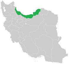 The Golan Heights has been in the news recently, both because fighting in southwestern Syria is pushing refugees towards it and because some groups in the U.S. are encouraging the Trump Administration to recognize Israel's sovereignty over the Golan Heights. (Israel acquired the Golan Heights from Syria in 1967's Six-Day War. Previously, Syria's southern border extended to the edge of the Sea of Galilee.) The Golan Heights is a hilly plateau (average elevation: 3300 ft.) that rises steeply from the Jordan River valley, making it a strategic asset. upload.wikimedia.org/wikipedia/commons/thumb/1/12/Golan_heights_rel89-orig.jpg/375px-Golan_heights_rel89-orig.jpg 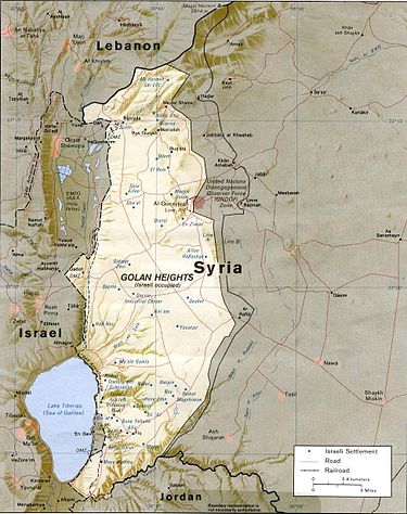 Not a map, but this geo-graphic shows the countries with the highest number of refugees per 1,000 inhabitants. As a total number (not a ratio), Turkey continues to host the most refugees, an issue that has been discussed in the lead up to Turkey's elections tomorrow. www.statista.com/chart/14323/countries-with-most-refugees-per-1000-inhabitants/
We are about at the halfway point of Ramadan, the month during which observant Muslims fast from sunrise to sunset. But, as this map shows, the time between sunrise and sunset varies greatly depending on where one is, from 11.5 hours in Melbourne to nearly 19.5 hours in Oslo. (However, according to this article, most Muslim scholars agree that Muslims near the poles can choose to fast during the daylight hours for Mecca or for the nearest Muslim-majority country, which in the case of Norway would be Bosnia.) www.statista.com/chart/13924/ramadan-fasting-times/
Last week, the U.S. opened its controversial new embassy in Jerusalem. Eighty-six countries with diplomatic missions in Israel received invitations to attend. This map shows which countries decided to send representatives to mark the occasion. infographic.statista.com/normal/chartoftheday_13851_who_attended_the_us_embassy_opening_in_jerusalem_n.jpg
This article gives visual examples of distinctive elements of Islamic architecture, from the minaret to the ogee arch to the muqarnas. mymodernmet.com/islamic-architecture
Three years in, the civil war in Yemen shows no signs of a resolution and has devolved into one of the world's worst humanitarian crises, marked by cholera, widespread malnutrition, and mass displacement of civilian populations in addition to an average of one air strike every 100 minutes by the Saudi-led coalition. This map, from a recent report by Chatham House (UK), scratches the surface of the complexity of the Yemeni situation. reader.chathamhouse.org/epubs/631/images/CHHJ5863-Yemen-Map1-Internal-Divisions.png
For the full report, see www.chathamhouse.org/sites/files/chathamhouse/publications/research/2017-12-20-yemen-national-chaos-local-order-salisbury2.pdf |
Blog sharing news about geography, philosophy, world affairs, and outside-the-box learning
Archives
December 2023
Categories
All
|
 RSS Feed