|
Stronger-than-usual trade winds are shifting water temperatures in the Pacific Ocean, creating a La Niña effect that is expected to influence weather patterns through the winter and into the spring. Because La Niña impacts vary with the location, check out the maps in this article to see what might be in store for you: www.wsj.com/articles/la-nina-is-coming-to-shape-winter-forecasts-what-to-know-11636666122
0 Comments
Biogeography includes the geographic range of microbes, and the virus that causes COVID, SARS-CoV-2, now seems to be taking up residence in U.S. white-tailed deer populations. A recently published study found that 30% of the white-tailed deer tested in Iowa from Apr. through Dec. 2020 were infected with SARS-CoV-2, with 80% testing positive during the parallel surge in Iowa's human population last winter. Genetic analysis revealed the deer were being infected by the same variants circulating in humans at the time. These findings suggest white-tailed deer are becoming a wild reservoir for the virus in North America, making eradication all but impossible and raising the possibility of new mutations that evolve in deer and spillover into livestock and back into humans. www.npr.org/sections/goatsandsoda/2021/11/10/1054224204/how-sars-cov-2-in-american-deer-could-alter-the-course-of-the-global-pandemic
Scientists from the University of Copenhagen accidentally discovered the world's northernmost island -- and added 20,000 square feet to Denmark's territory in the process -- when they went, by helicopter, to collect biological samples from a remote island off the northeastern coast of Greenland named Oodaaq (shown in green on this map), previously believed to be the world's northernmost island, and instead put down on an as-yet-unnamed mound of silt and gravel 780 m. further north. Islands of sediment shaped by the currents, like the newly discovered island, are often transitory, coming and going with major storm action. 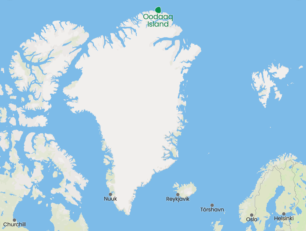 "Extirpation" is one the biogeography terms my geography students learn in the course of their studies. This map shows the current range of the jaguar (in green) as well as its historic range, from which the jaguar has been extirpated (in yellow).
c402277.ssl.cf1.rackcdn.com/photos/22252/images/magazine_medium/Jaguar_map2_WWfall2021.png (Map from www.worldwildlife.org/magazine/issues/fall-2021/articles/restoring-the-jaguar-corridor.) Haiti's M7.2 earthquake last weekend is believed to have been triggered by the same fault as the M7.0 earthquake that leveled parts of Port-au-Prince, Haiti's capital, in 2010. Most of the Caribbean is seismically active, as this map shows. The strongest earthquake to hit the Caribbean in modern times was the 1843 earthquake in Guadeloupe (part of the eastern arc of Caribbean islands known as the Lesser Antilles), which could be felt as far away as NYC and is thought to have had a magnitude as high as 8.5, which would have been more than 10x more powerful than Haiti's recent earthquake! cdn.mos.cms.futurecdn.net/vAbzhEgRFTmUyweedLUVw-1200-80.jpg
As we are already seeing, changes in the climate do not have the same impact across all regions. This geo-graphic from Statista summarizes the changes in key elements of physical geography -- precipitation patterns and temperature -- forecast in this week's Intergovernmental Panel on Climate Change, by region. www.statista.com/chart/25511/scientific-consensus-climate-change-patterns-world-regions
Vice President Kamala Harris's recent trip to Guatemala to discuss illegal immigration reflects Guatemala's status as the #1 source country for people apprehended by the U.S. Border Patrol trying to gain illegal entrance to the United States. This map shows the top 10 source countries in FY2019, which is the most recent annual data released by the U.S. Border Patrol showing citizenship. The top two countries, by far, are Guatemala and Honduras which, together, accounted for more than 60% of all apprehensions.  The Canadian city of Kamloops, British Columbia, has been in the news recently as the site of a controversial and now-closed school for indigenous children originally run by a Catholic missionary order. Many Americans, to the extent they are familiar with British Columbia at all, may have visited areas in and near Vancouver without appreciating the size and diversity of the province. Kamloops, for instance, lies between Canada's Coast Mountains to the west and the Rockies to the east, which combine to provide Kamloops with rivers, foothills suitable for hiking and vineyards, and a warm, dry, sunny climate. 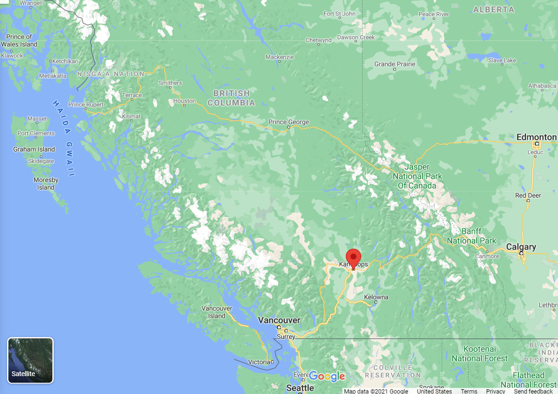 This map has been in the news this week as climate scientists are trying to call attention to the impact of cooling waters off Greenland's southeastern coast: www.cbsnews.com/news/climate-change-map-warning/
A recent study published in Nature Geoscience finds that 64% of arable land worldwide -- including much of the world's most productive, intensively farmed land -- is at risk of poisoning by pesticides. The problem is most severe in China, Japan, Malaysia, and the Philippines. This map shows the areas at greatest risk (the darker the color, the greater the projected risk). scitechdaily.com/64-of-farmland-at-risk-of-pesticide-pollution-revealed-in-global-map-of-agricultural-land-across-168-countries/
Today is the vernal (or spring) equinox. The vernal equinox and the autumnal (or fall) equinox are the same in that both have equal amounts of day and night, but equal sunlight does not translate into equal temperatures, as this map of much of North America shows: www.alaskapublic.org/wp-content/uploads/2018/03/03202018_Climate2.jpg.
Greenland's snap elections scheduled for Apr. 6 are generating an unusual level of international interest, in no small part because of Greenland's emergence as a potentially significant source of rare-earth metals and the controversy surrounding the ownership, politics, and consequences of a huge new rare-earth/uranium mine being planned. foreignpolicy.com/2021/03/10/greenland-election-rare-earth-elements-china-us-europe
Swedish carmaker Volvo announced this week that it will cease manufacturing cars with internal combustion engines in less than a decade, by 2030. This map shows current plans by various national and subnational governments to phase out sales of internal combustion cars. sailthru-media.s3.amazonaws.com/composer/images/sailthru-prod-53o/Global-ICE-phaseout-map-nov2020.png
Until the U.S. passed the grim milestone of 500,000 COVID deaths recently, over the last month most COVID news in the U.S. has focused on aspects of vaccine rollouts. But as of earlier this week, the countries shown in red on this map have not yet been able to start COVID vaccinations: www.statista.com/chart/24242/status-of-global-vaccination-campaigns
What will happen to the partially built wall on the U.S.-Mexico border? This article from Bloomberg CityLab discusses the actual construction -- of the 450 miles of wall completed during the Trump administration, only 80 miles were barriers erected where none existed previously, with the remaining 370 miles being upgrades to pre-existing walls -- the native and wildlife communities threatened by a physical barrier, and options for high-tech virtual fencing: www.bloomberg.com/news/features/2021-01-21/what-will-become-of-donald-trump-s-border-wall
For most U.S. households, Dec. 31 is the end of the tax year. A recent report by the Tax Justice Network finds that private offshore tax evasion by individuals costs the U.S government more than $40 billion per year in lost tax revenue. The Tax Justice Network classifies nearly 40% of global bank deposits as "abnormal." This chart shows the top 15 geographic jurisdictions facilitating global tax abuse; the chart is ordered by total value of abnormal deposits, but the next column shows abnormal deposits as a percentage of all deposits, which is also illuminating. (From taxjustice.net/wp-content/uploads/2020/11/The_State_of_Tax_Justice_2020_ENGLISH.pdf)
During Latin America's "dirty wars" in the 1970s and '80s, as many as 30,000 Argentinians and 3,400 Chileans disappeared. However, in the last 14 years more than 79,000 Mexicans have disappeared, often victims of narcoterrorism, human trafficking, kidnapping, and state security forces. With new mass graves being exhumed regularly, this article from The Washington Post profiles the search for Mexico's disappeared and the fragile security situation in the United States's most populous neighbor and 2nd-largest trading partner.
www.washingtonpost.com/graphics/2020/world/mexico-losing-control/mexico-disappeared-drug-war/ A recent report from the British nonprofit Save the Children finds that approximately one out of every six children on earth is living in a conflict zone, and "165 million of these children are affected by high intensity conflicts." This map shows the areas with the largest numbers of children living in conflict zones, including Honduras, with a total population of fewer than 10 million. For the complete report, see www.savethechildren.org.uk/content/dam/global/reports/education-and-child-protection/war_on_children-web.pdf
The wild turkey is native to North America, but there are at least half a dozen subspecies of wild turkeys that reside in the U.S., Mexico, and a bit of southern Canada. This map from the National Wild Turkey Federation shows the current ranges of the various subspecies of wild turkey. www.nwtf.org/hunt/wild-turkey-basics/habitat
Elections and wars are inflection points rich in counterfactuals. The series of maps in this BBC Future article considers alternate histories, which have become a field of serious historical scholarship: what if the U.S. had lost the American Revolution? what if WWII hadn't been fought? what if the states of the United States had splintered in line with some actual proposals? www.bbc.com/future/article/20201104-the-intriguing-maps-that-reveal-alternate-histories
Gold prices have risen 25% since the beginning of the year. This map shows the world's major gold-producing regions, by tonnes mined. www.statista.com/chart/23053/gold-mines-by-tonnes-produced-annually
The U.S.-Canada border has been effectively closed due to COVID-19 since March 31. But Canadians, considered some of the world's most polite people, are reportedly getting irritated by Americans entering illegally. (After some acts of vandalism and intimidation, the premier of British Columbia asked Canadians to "Be Calm. Be Kind.") This recent geo-graphic from The New York Times, which shows the number of new COVID cases in the last month, gives some insight into why Canadians do not want Americans crossing the border. Adjusted for population, the U.S. had roughly 18x as many new COVID infections as Canada. (From the print version of www.nytimes.com/2020/08/06/us/coronavirus-us.html.)
Canada's last intact ice shelf, the second largest in the Arctic, has collapsed, losing more than 40% of its area in just two days in early July, satellite images show. The Milne ice shelf was on the northern coast of Canada's Ellesmere Island, northwest of Greenland. (Despite its remote location, Ellesmere is the world's 10th largest island.) www.severe-weather.eu/global-weather/milne-ice-shelf-collapse-canada-mk/
Openness to new people and ideas (or not) has played an important role in the economic rise and fall of geographic regions, be they countries, empires, or subsets thereof. This article from MIT Technology Review looks at the "nice person's" Silicon Valley and Canada's bid to attract talented immigrants who perhaps otherwise would have been headed to the U.S. www.technologyreview.com/2020/06/17/1003314/toronto-would-like-to-be-seen-as-the-nice-persons-silicon-valley-if-thats-not-too-much-trouble
High above the Arctic Circle, on the summer solstice, the Siberian town of Verkhoyansk reported a high temperature of more than 100°F. If verified, this would be the highest temperature ever recorded in the Arctic. Although late June is the height of the Arctic summer, Siberia has been usually warm since January. This map, based on NASA satellite data, shows how much land surface temperature in northern latitudes has differed from the 15-year average throughout the entire spring: eoimages.gsfc.nasa.gov/images/imagerecords/146000/146879/arctic_amo_2020172.png (It is useful to keep in mind that 2003-18 temperatures were already higher than the historic norm.)
|
Blog sharing news about geography, philosophy, world affairs, and outside-the-box learning
Archives
December 2023
Categories
All
|
 RSS Feed