|
The UN recently announced that outbreaks of ovine rinderpest, a highly contagious sheep and goat virus with a fatality rate of 30-70%, have fallen by two-thirds in the last few years following an aggressive animal vaccination campaign. According to the UN's Food and Agriculture Organization, some 300 million families worldwide rely on sheep and/or goats for food and income. This Reddit map highlights the nine countries in which there are actually more sheep than people: preview.redd.it/kbcnvrb260d61.jpg?width=960&crop=smart&auto=webp&s=aa0e81d39c1284f17aba8bbfb617683bd94345c8
0 Comments
From Australia to both coasts of the U.S. to Siberia, extreme weather set numerous records in 2020. This article from Science News recaps some of the year's extreme weather events around the world. www.sciencenews.org/article/climate-change-wildfires-heat-waves-hurricanes-records-2020
When students in my "Hands-On Geography" and "Geography: Live Online!" classes study biogeography, they are often surprised to learn that Australia has camels. Australia's feral camel population illustrates the interplay between physical geography and human geography that often shapes biogeographic distribution. This article from BBC Travel provides a look at Australia's unexpected, and unexpectedly large, camel population (at least 1 million and growing rapidly). www.bbc.com/travel/story/20180410-the-strange-story-of-australias-wild-camel
With Vanuatu reporting its first COVID case earlier this month, this map shows the remaining handful of nations that have had no reported COVID infections. ("Reported" is an important caveat, especially in the cases of Turkmenistan and North Korea.) www.statista.com/chart/21279/countries-that-have-not-reported-coronavirus-cases
Last weekend the Regional Comprehensive Economic Partnership was signed by 13 Asian countries plus Australia and New Zealand to create the world's largest trading bloc, covering roughly 30% of the world's population and GDP. This map, from Asia Times, shows the 15 countries now joined in the RCEP free-trade zone (in teal). India withdrew from negotiations last year over concerns the agreement would hurt domestic producers. (The RCEP is the successor to the Trans-Pacific Partnership, which the U.S. had initialed during Pres. Obama's term in 2016 and then withdrew from on the first full day of Pres. Trump's term in January 2017. The RCEP is widely seen as a signal of China's economic influence in the region.) i0.wp.com/asiatimes.com/wp-content/uploads/2020/11/world_map_dec09.jpg
Trees don't just lose their leaves. Some lose their bark as well. This article profiles the rainbow eucalyptus tree, the only eucalyptus tree native to the Northern Hemisphere (the Philippines) and one of only four eucalyptus species (out of 700+) that is not found in Australia. When the bark peels, an assortment of colors is revealed. www.insider.com/rainbow-eucalyptus-trees-bark-photos-nature
Gold prices have risen 25% since the beginning of the year. This map shows the world's major gold-producing regions, by tonnes mined. www.statista.com/chart/23053/gold-mines-by-tonnes-produced-annually
Different countries have different approaches to policing. This geo-graphic shows, in alphabetically order, the 18 nations that do not routinely arm their police. www.statista.com/chart/10601/where-are-the-worlds-unarmed-police-officers
As of this writing, these are the 13 countries with no *reported* cases of COVID-19: North Korea, Turkmenistan, Lesotho, and the Pacific Island nations of Federated States of Micronesia, Kiribati, Marshall Islands, Nauru, Palau, Samoa, Solomon Islands, Tonga, Tuvalu, and Vanuatu. 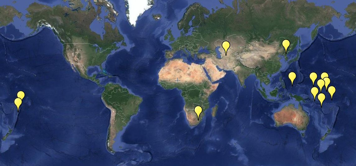 Vanuatu and the Solomon Islands have been in the news this week, having been hit by a massive late-season Category 5 cyclone. (In the southern hemisphere, the tropical storm season is reversed because the seasons are reversed. In both hemispheres, fall generally brings cooling waters and an end to the tropical storm season.) Lying northeast of Australia, the Republic of Vanuatu and the Solomon Islands are both volcanic archipelagos in the region of the South Pacific between the equator and the Tropic of Capricorn known as Melanesia. upload.wikimedia.org/wikipedia/commons/thumb/5/59/Oceania_UN_Geoscheme_-_Map_of_Melanesia.svg/1920px-Oceania_UN_Geoscheme_-_Map_of_Melanesia.svg.png
Tomorrow is the beginning of daylight savings time in those parts of the United States that adopt daylight savings time. Another time oddity is the International Date Line, the imaginary line that roughly corresponds to a longitude of 180°. The west side of the line is a day ahead of the east side of the line. Although the line jogs around certain political entities, it still creates for some curious situations, especially as far as islands are concerned. In the South Pacific, clocks in Tonga and American Samoa, for example, will show precisely the same time, but Tonga is a day ahead of American Samoa because, even though they share a time zone, Tonga is on the west side of the International Date Line. In the North Pacific, Big Diomede and Little Diomede are two islands that sit 2.5 miles apart in the Bering Strait but are separated by the International Date Line (and geopolitics). Big Diomede, part of Russia, is a day ahead of Little Diomede, which is part of Alaska, leading to their respective nicknames Tomorrow Island and Yesterday Island. static01.nyt.com/images/2012/07/31/opinion/31borderlines/31borderlines-blog427.jpg
Many Americans don't appreciate the size of Australia or the scope of the country's current wildfire season. This map, from ABC News, superimposes Australia and the location of last month's active wildfires on a map of the contiguous U.S. s.abcnews.com/images/International/AustralianWildfires_v01_sd_hpMain_16x9_992.jpg
One last photo instead of a map. This is the Hawaiian state fish, known in English as the reef triggerfish. In Hawaiian, its name is humuhumunukunukuapua'a. The Hawaiian language was oral, not written, until missionaries arrived in the islands in the early 1800s and used English letters to capture Hawaiian sounds. It turns out that the Hawaiian language employed only 12 sounds: the five vowels plus seven consonants (h, k, l, m, n, p, and w). Not surprisingly, many Hawaiian words transcribed into English are long and, to outsiders, look confusingly similar. The Hawaiian language is related to languages spoken elsewhere in Oceania, including Tongan, Maori, Samoan, and Tahitian. (Politically, Hawaii may be part of the United States, but geographically it is actually part of Oceania.) 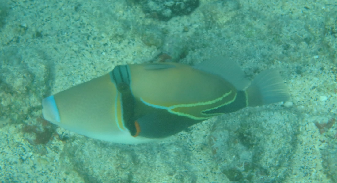 Most of the Hawaiian islands are fringed by coral reefs, providing Hawaii with the best snorkeling in the United States. This photo was taken near where British explorer Captain James Cook met his demise. (Kidnapping a local chief and holding him hostage for supplies turned out not to be a good idea.) 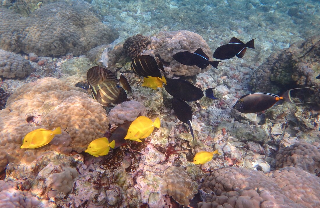 Not a map today but a photo: a tray of lilikoi (passion fruit-filled) malasadas. A malasada is a Hawaiian treat, a yeast doughnut brought to the islands by Portuguese immigrants. In the second half of the 19th century, Portuguese sugarcane workers were recruited in the Azores to come work in Hawaii's sugarcane fields. Although there is no longer any commercial sugar production in Hawaii -- the last sugar mill closed in 2016 -- there are still sugary malasadas, a reflection of Hawaii's complex cultural geography. 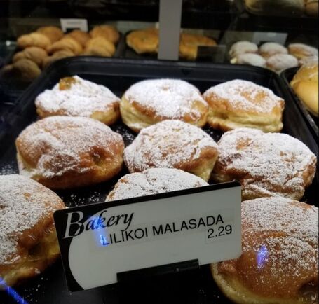 According to the U.S. Geological Survey, there are nearly 1500 volcanoes around the world believed to be active, of which more than half are located in the six countries shown in red on this map. The U.S. has 169 "potentially active" volcanoes, the majority of which are in Alaska. Hawaii has five volcanoes that have erupted in the last 250 years: Kilauea (erupted nearly continuously from 1983 to 2018), Mauna Loa (last erupted in 1984 but believed to be poised to erupt again soon), Loihi (last erupted 1996), Hualalai (last erupted 1801), and Haleakala (last erupted about 1790). Haleakala is on Maui; all of the rest are on the island of Hawaii. 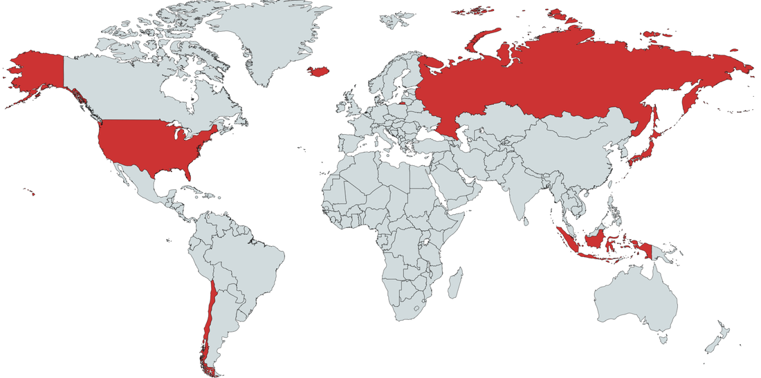 Australia has been in the news recently due to its intense heat and wildfires. This map, from Meteoblue which shows global high temperatures for today, helps illustrate why. 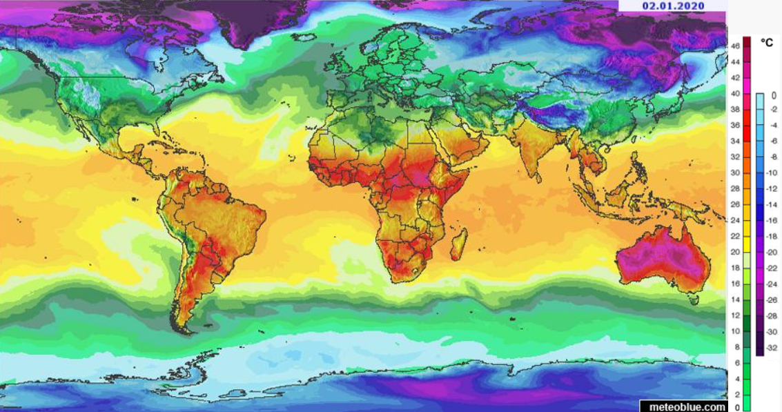 When the country of Papua New Guinea became independent of Australia in 1975, the islands to the east that had been known as the German Solomon Islands when Germany controlled what is today Papua New Guinea, were incorporated into Papua New Guinea as the Autonomous Region of Bougainville (shown in red on this map). The results of a recent referendum were announced last week: 98% of voters in the Autonomous Region of Bougainville voted to become an independent country, which is not entirely surprising given that the mineral-rich islands have agitated for independence, sometimes violently, for more than 50 years.
upload.wikimedia.org/wikipedia/commons/thumb/c/c4/Bougainville_in_Papua_New_Guinea_%28special_marker%29.svg/1920px-Bougainville_in_Papua_New_Guinea_%28special_marker%29.svg.png New Zealand was in the news this week when a volcano just off the northern coast of New Zealand's North Island erupted unexpectedly. There are about a dozen volcanoes on or just offshore the North Island, part of the Pacific "Ring of Fire," as students who have taken my "Hands-On Geography" class may be able to predict. This map shows where the Pacific Plate is subducting under the Australian plate just to the east of the North Island, creating the Kermadec Trench and, about 200 miles to the west, a band of volcanoes, including the one that just erupted. upload.wikimedia.org/wikipedia/commons/thumb/8/8a/NZ_faults.png/800px-NZ_faults.png
According to recent data compiled by the OECD, a quarter of doctors practicing in the U.S. received their first medical degree somewhere other than the U.S. This geo-graphic compares the prevalence of foreign-trained doctors across various OECD countries: www.statista.com/chart/3849/the-countries-with-the-most-foreign-trained-doctors/
Assembling data from nearly 7000 sites around the world, researchers have assembled the first map of global earthworm distribution. "During the 1800s, intrepid explorers collected and cataloged many of the world’s plants and animals, providing range maps for different species that launched further study. But that wasn’t true for subterranean life. ... [E]arthworms have been studied long enough in Europe that most of the species are known. (The United Kingdom has 33 kinds.) But in the tropics, 'Every time they dig a hole, they find a new species of earthworm,' [soil ecologist Helen] Phillips says. ... [Researchers] were surprised when their analysis showed that temperature and rainfall seem to have a greater influence on where earthworms do best than soil type, they report today in Science. ... The effects of temperature and rainfall suggest climate change will have a far greater influence on below-ground life than expected, they say. Consequently, life above ground might also be affected in ways not previously anticipated. The distribution of different earthworm species was also surprising. When it comes to life above ground, the tropics have the greatest biodiversity. But underground, these constantly warm regions are far less diverse, at least at a local scale: The rich soils of Europe, the northeastern United States, the southern tip of South America, and the southern regions of New Zealand and Australia seem to have more earthworm species in a given area. Those temperate zones also host more earthworms overall, according to the model, with up to 150 per square meter versus just five per square meter in the tropics." www.sciencemag.org/news/2019/10/first-global-map-earthworms-reveals-which-places-are-chock-full-them-and-why
This map of Australia divides the population half: the area shown in red and the area shown in gray have equal numbers of people (roughly 11 million in each).
preview.redd.it/eefmhyda8yo31.png?width=960&crop=smart&auto=webp&s=b42a4cc72e09ea99249d8a67d394db4a7313253b The island of Yap in the Federated States of Micronesia was in the news this week. For most people, though, Yap's exact whereabouts were a bit of a head-scratcher. This map shows Yap to be in the Pacific at the far western end of the Federated States of Micronesia, east of the Philippines and southwest of the U.S. territory of Guam. www.visityap.com/wp-content/uploads/2014/11/whereisyap.jpg
During the last ice age, global geography would have appeared quite different, with extensive land and sea ice lowering ocean levels significantly. This Reddit map tries to recreate global geography as it would have existed 21,000 years ago. Although the ice coverage is eye catching, a careful look at southeast Asia, western Asia, and Oceania, for example, shows the way a drop in sea level changed the geography of these regions dramatically, a history that still echoes in their biogeography. i.redd.it/drvhvjbtw3b31.jpg
|
Blog sharing news about geography, philosophy, world affairs, and outside-the-box learning
Archives
December 2023
Categories
All
|
 RSS Feed