|
High above the Arctic Circle, on the summer solstice, the Siberian town of Verkhoyansk reported a high temperature of more than 100°F. If verified, this would be the highest temperature ever recorded in the Arctic. Although late June is the height of the Arctic summer, Siberia has been usually warm since January. This map, based on NASA satellite data, shows how much land surface temperature in northern latitudes has differed from the 15-year average throughout the entire spring: eoimages.gsfc.nasa.gov/images/imagerecords/146000/146879/arctic_amo_2020172.png (It is useful to keep in mind that 2003-18 temperatures were already higher than the historic norm.)
0 Comments
This article explains current research to understand Thwaites, the world's "riskiest" and "most important" glacier, according to some scientists. "A complex interplay of topography, climatic change and ocean currents have coalesced to make the western regions of Antarctica (where Thwaites is situated) particularly vulnerable. Topography is critical when it comes to the reasons why Thwaites is acutely exposed. Antarctica is often split into East and West – not simply to make the vast continent easier to represent but because there are fundamental differences between the regions. ‘East Antarctica is principally a large continent with mountain ranges and thick ice, but west Antarctica is more like an archipelago of islands – predominantly below sea level and vulnerable to change,’ explains [Andy] Smith [a senior glaciologist at the British Antarctic Survey]. The increased presence of warmer water, carried towards the southern polar regions by ocean conveyors, is exacerbating issues. Usually, the continental shelf keeps the warm water in the deep ocean surrounding the continent. In recent decades, however, more warm water has got over the continental shelf and flowed down towards the ice. If the warm water thins the ice, it also opens up a larger gap underneath the sheet, exposing more of the underlying ice and potentially precipitating an accelerated rate of retreat. Thwaites is of particular interest not only due to its scale and the underlying topography but also due to what it is supporting. ‘Thwaites has access to a massive inland reservoir of ice and so changes to Thwaites could affect the whole ice sheet,’ says Smith. ‘Other glaciers are still important, but they don’t have the same potential to have such a significant impact on sea level rise.’ Ice draining from Thwaites accounts for approximately four per cent of global sea-level rise and the collapse of the glacier could potentially cause global sea levels to rise by up to 80cm." geographical.co.uk/nature/polar/item/3606-investigating-thwaites-the-riskiest-glacier-on-earth
Tomorrow is the beginning of daylight savings time in those parts of the United States that adopt daylight savings time. Another time oddity is the International Date Line, the imaginary line that roughly corresponds to a longitude of 180°. The west side of the line is a day ahead of the east side of the line. Although the line jogs around certain political entities, it still creates for some curious situations, especially as far as islands are concerned. In the South Pacific, clocks in Tonga and American Samoa, for example, will show precisely the same time, but Tonga is a day ahead of American Samoa because, even though they share a time zone, Tonga is on the west side of the International Date Line. In the North Pacific, Big Diomede and Little Diomede are two islands that sit 2.5 miles apart in the Bering Strait but are separated by the International Date Line (and geopolitics). Big Diomede, part of Russia, is a day ahead of Little Diomede, which is part of Alaska, leading to their respective nicknames Tomorrow Island and Yesterday Island. static01.nyt.com/images/2012/07/31/opinion/31borderlines/31borderlines-blog427.jpg
As sea ice in the Arctic recedes, channels are opening connecting the North Atlantic and the North Pacific. While this is normally discussed in terms of navigation and geopolitics, this article considers these channels as unprecedented avenues for the exchange of marine microbes. geographical.co.uk/nature/wildlife/item/3542-channel-hopping
An "ice tsunami," sometimes called an "ice shove" or "walking ice," occurs when winds and/or currents force ice out of the water and up a sloping shore. These can result in ice walls up to 40 feet high. In the U.S., ice tsunamis generally happen during the winter, typically in the Great Lakes region. In Siberia, though, ice tsunamis often mark the beginning of summer. This video of an ice tsunami was recorded last June on the Yenisei River, one of Russia's longest rivers and the largest river system running to the Arctic Ocean. www.youtube.com/watch?v=CAb26ebanKE
"According to a new U.S. Army report, Americans could face a horrifically grim future from climate change involving blackouts, disease, thirst, starvation and war. The study found that the US military itself might also collapse. This could all happen over the next two decades, the report notes. The senior US government officials who wrote the report are from several key agencies including the Army, Defense Intelligence Agency, and NASA. The study called on the Pentagon to urgently prepare for the possibility that domestic power, water, and food systems might collapse due to the impacts of climate change as we near mid-century. The two most prominent scenarios in the report focus on the risk of a collapse of the power grid within “the next 20 years,” and the danger of disease epidemics. Both could be triggered by climate change in the near-term, it notes.
“Increased energy requirements” triggered by new weather patterns like extended periods of heat, drought, and cold could eventually overwhelm “an already fragile system.” The report also warns that the US military should prepare for new foreign interventions in Syria-style conflicts, triggered due to climate-related impacts. Bangladesh in particular is highlighted as the most vulnerable country to climate collapse in the world. ... But without urgent reforms, the report warns that the US military itself could end up effectively collapsing as it tries to respond to climate collapse. It could lose capacity to contain threats in the US and could wilt into “mission failure” abroad due to inadequate water supplies." Excerpted from www.vice.com/en_us/article/mbmkz8/us-military-could-collapse-within-20-years-due-to-climate-change-report-commissioned-by-pentagon-says The report itself is available here: climateandsecurity.files.wordpress.com/2019/07/implications-of-climate-change-for-us-army_army-war-college_2019.pdf During the last ice age, global geography would have appeared quite different, with extensive land and sea ice lowering ocean levels significantly. This Reddit map tries to recreate global geography as it would have existed 21,000 years ago. Although the ice coverage is eye catching, a careful look at southeast Asia, western Asia, and Oceania, for example, shows the way a drop in sea level changed the geography of these regions dramatically, a history that still echoes in their biogeography. i.redd.it/drvhvjbtw3b31.jpg
Greenland, which is administered by Denmark, has been in the news lately. Greenland is the world's biggest island. This map shows the world's 10 biggest islands: www.statista.com/chart/19047/total-area-of-the-worlds-largest-islands/ It should be noted, though, that because of the mapping projection used, the size of Greenland and the other Arctic islands is greatly magnified. (My "Hands-On Geography" students sometimes ask, "Why is Greenland an island and Australia isn't?" There is no excellent answer to this question. You will find things like this www.worldislandinfo.com/CONTISLAND.html online, but Australia was named a continent prior to a scientific understanding of tectonic plates and the flora and fauna are not truly unique in that there are striking similarities to species in Indonesia and the Philippines east of the Wallace Line. In other words, geographers lucked into some scientific support for their classification of Australia, and not Greenland, as a continent rather than an island.)
For those accustomed to looking at some variant of the standard Mercator projection map (with the equator in the middle, the Americas to the left and Europe, Africa, Asia, and Australia to the right), this "vertical world map" from China will look radically different, with an emphasis on the Arctic and Asia. bigthink.com/strange-maps/future-world-map
Greenland lost an estimated 2 billion tons of ice in just one day last week. Although the ice sheets of Antarctica account for roughly 90% of the world's ice, Greenland's ice sheets account for much of the remaining 10%. "The Arctic's melt season is a natural event that takes place every year, starting in June and ending in August, with peak rates occurring in July. However, the scale of ice loss taking place right now is extraordinary. Experts have already made comparisons to 2012, which saw record-breaking ice loss when almost all of Greenland's ice sheet was exposed to melt for the first time in documented history. This year, ice melt began even earlier than 2012 and three weeks earlier than average." www.iflscience.com/environment/greenland-lost-more-than-2-billion-tons-of-ice-in-just-one-day-last-week
"For more than 35 years, satellites circling the Arctic have detected a 'greening' trend in Earth’s northernmost landscapes. Scientists have attributed this verdant flush to more vigorous plant growth and a longer growing season, propelled by higher temperatures that come with climate change. But recently, satellites have been picking up a decline in tundra greenness in some parts of the Arctic. Those areas appear to be 'browning.'" Loss of insulating snow cover, predation by insects that have also expanded their ranges and flourished, and Arctic wildfires all appear to be contributing to this newly observed browning. www.sciencenews.org/article/climate-change-arctic-browning
Scientists have discovered that Antarctica has a "song" and that monitoring the song provides clues about the stability of the ice.
"The Ross Ice Shelf is the largest expanse of floating ice on the planet (similar to the size of France). Because of this, it acts as a buttress, holding back the Antarctic glaciers, preventing them from flowing into the ocean. ... Monitoring the ice shelf is therefore essential and scientists ... have discovered a new tool with which to do so. In 2014, the team buried 34 super-sensitive seismic sensors beneath the ice shelf’s surface, a terrain made up of a thick blanket of snow several metres deep and rippled by massive dunes. The instruments measured seismic signals – the waves of energy produced by movement within the earth. The data revealed that winds whipping across the snow dunes cause the ice shelf’s surface to vibrate. This steady vibration results in the emission of seismic ‘tones’. ... Rick Aster, professor of geophysics at Colorado State University and a member of the team, explains that ... when weather conditions change, the pitch of the hum responds. ‘A remarkable thing we discovered during this study was that even during a relatively subtle warming event that only produced a tiny bit of melt on the ice shelf, we could see very strong indications in this signal,’ he says. ‘It enables us to monitor the temperature and the melting of the surface of an ice shelf on a minute-by-minute basis.’" This links to the full article and allows visitors to "listen" to the Antarctic ice: geographical.co.uk/nature/polar/item/3021-antarctic-song The earth's magnetic north pole is known to wander around, but it is now moving quickly along an unexpected trajectory, requiring emergency adjustments to global navigational systems.
"Something strange is going on at the top of the world. Earth’s north magnetic pole has been skittering away from Canada and towards Siberia, driven by liquid iron sloshing within the planet’s core. The magnetic pole is moving so quickly that it has forced the world’s geomagnetism experts ... to update the World Magnetic Model, which describes the planet's magnetic field and underlies all modern navigation, from the systems that steer ships at sea to Google Maps on smartphones. ... The pole wanders in unpredictable ways that have fascinated explorers and scientists since James Clark Ross first measured it in 1831 in the Canadian Arctic. In the mid-1990s it picked up speed, from around 15 kilometres per year to around 55 kilometres per year. By 2001, it had entered the Arctic Ocean — where, in 2007, a team including Chulliat landed an aeroplane on the sea ice in an attempt to locate the pole. In 2018, the pole crossed the International Date Line into the Eastern Hemisphere. It is currently making a beeline for Siberia." www.nature.com/articles/d41586-019-00007-1 As the Arctic heats up (literally), territorial disputes between the eight Arctic countries are also expected to heat up. At issue are fishing rights, mineral rights, navigation rights, and military use in a region that has, for the most part, previously been inaccessible and irrelevant. This article from Geographical (UK) lays out the spat between Canada and Denmark, for example, over a tiny island in the narrow Kennedy Channel separating Greenland (which is administered by Denmark) from Canada's Ellesmere Island. geographical.co.uk/geopolitics/geopolitics/item/2834-divided-island
Scientists recently reported finding the coldest spot on earth: a section of the East Antarctic ice sheet that registered -144°F. Because this area of East Antarctica is too cold and remote to be measured by scientists on the ground, the spot was identified by analyzing satellite data. This significantly exceeds the previously documented low temperature of -129°F (also in Antarctica) and is believed to be close to the minimum temperature possible on our planet. news.nationalgeographic.com/2018/06/coldest-place-earth-measured-temperature-antarctica-science
A recent article in the science journal Nature reported that 40% of the 3 trillion tons of ice shed by Antarctica over the last 25 years has been lost in the last 5 years. "At its current rate, Antarctica's ice loss will add six inches to sea-levels by 2100, which is in the upper range of what the Intergovernmental Panel on Climate Change estimates Antarctica will contribute to sea level rise, and translates to serious impacts on Earth. 'Around Brooklyn you get flooding once a year or so, but if you raise sea level by 15 centimeters then that’s going to happen 20 times a year,' Andrew Shepherd, a professor of earth observation at the University of Leeds and the lead author of the study told the New York Times. ... The study also helped clarify the ambiguity regarding ice loss in different regions in Antarctica. While West Antarctica and the Antarctic Peninsula has been losing ice for a long time, East Antarctica has experienced a mix of ice gain and loss, which some has cited as a reason not to worry about global warming. The latest study emphasizes that the variations in East Antarctica are not nearly enough to make up for the rapid loss throughout the rest of the continent." www.popularmechanics.com/science/environment/a21577520/antarctica-melting-way-faster-anyone-expected/
Most of the world maps we use, regardless of projection, offer roughly the same perspective: dividing the globe near the International Date Line and putting the equator more or less in the middle. This map provides an unusual perspective with Antarctica in the center. www.reddit.com/r/MapPorn/comments/8hn1ow/antarcticcentric_world_view/
Antarctica is known to be geothermically active. "A new NASA study adds evidence that a geothermal heat source called a mantle plume lies deep below Antarctica's Marie Byrd Land, explaining some of the melting that creates lakes and rivers under the ice sheet. Although the heat source isn't a new or increasing threat to the West Antarctic ice sheet, it may help explain why the ice sheet collapsed rapidly in an earlier era of rapid climate change, and why it is so unstable today. The stability of an ice sheet is closely related to how much water lubricates it from below, allowing glaciers to slide more easily. Understanding the sources and future of the meltwater under West Antarctica is important for estimating the rate at which ice may be lost to the ocean in the future. Antarctica's bedrock is laced with rivers and lakes, the largest of which is the size of Lake Erie." This map shows the continent's subglacial rivers and lakes. www.jpl.nasa.gov/news/news.php?feature=6996 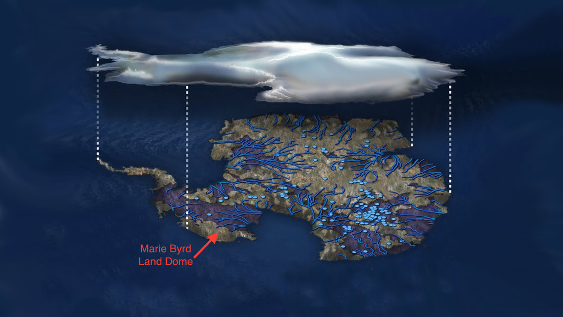 Antarctica is our most challenging continent to study, but what's going on there (or isn't) is pivotal to accurate estimates of sea level rise, which in turn are pivotal to the tens of millions of people living within a few meters of sea level. This TED Talk discusses how researchers are using radar and radio to peer through 3 km of ice to better understand how Antarctica may be changing.
www.ted.com/talks/dustin_schroeder_how_we_look_kilometers_below_the_antarctic_ice_sheet Welcome to the North Pole! This planar map provides a different perspective on the Arctic than a customary equator-centered map does. As the Arctic is heating up, literally, Arctic politics are also heating up, with conflict over shipping lanes, fishing rights, mineral rights, and militarization emerging between the eight countries bordering the Arctic Ocean as well as with indigenous peoples (including elves?). www.wolfram.com/mathematica/new-in-10/geographic-visualization/HTMLImages.en/map-the-north-pole-and-arctic-circle/O_11.png
It has long been known Antarctica is volcanic: Mt. Erebus is the world's southernmost active volcano and has been erupting continuously for decades. Geologists recently found 91 new volcanoes under Antarctica's ice sheets. These volcanoes, currently dormant, are clustered in Marie Byrd Land, the portion of Antarctica directly south of New Zealand. www.sci-news.com/featurednews/volcanoes-west-antarctica-05129.html
The International Ice Patrol, created after the sinking of the Titanic to monitor icebergs in the North Atlantic, has recorded 976 icebergs off Newfoundland so far this year, more than double the average. The icebergs drift into shipping lanes (generally south of 48◦ north latitude) and pose a threat to trans-Atlantic maritime traffic. This article from The Economist notes that number of icebergs varies considerably from year to year, depending on a variety of physical geography cues, including water and air temperature, ocean currents, and wind strength. www.economist.com/blogs/economist-explains/2017/06/economist-explains-14
If you want to learn more about Antarctica, this is your chance. EdX is offering a new (free) class, "Antarctica: From Geology to Human History," that takes participants on "a virtual field trip to Antarctica, as we go on location to explore the geology and history of the coldest, driest, windiest continent on earth." The class starts, online, tomorrow (4/15) and runs for five weeks. www.edx.org/course/antarctica-geology-human-history-victoriax-ice101x
A banana plantation 177 miles south of the Arctic Circle? Yes. Iceland takes advantage of its geothermal position on the Mid-Atlantic Ridge to grow bananas (in a greenhouse heated by volcanic hot springs). Geothermal sources provide 66% of Iceland's energy, including direct heating and 25% of its electricity generation. www.atlasobscura.com/articles/bananas-in-iceland
Last week it was reported that the sea ice surrounding Antarctica reached the lowest level in recorded history in January. In the Arctic, where it is winter, sea ice also set a new record low for January. This article from National Geographic asks, "What would the world look like if all of the planet's ice melted?" Check out the before-and-after map for each continent. www.nationalgeographic.com/magazine/2013/09/rising-seas-ice-melt-new-shoreline-maps/
|
Blog sharing news about geography, philosophy, world affairs, and outside-the-box learning
Archives
December 2023
Categories
All
|
 RSS Feed