|
These maps look at shifting precipitation patterns in the Midwest: comparing the map on the left (based on average rainfall from 1979-1991) to the map on the right (based on average rainfall from 1994-2016) it is clear the Midwest has become drier, meaning a greater proportion of "America's breadbasket" has become dependent on irrigation to maintain crop yields. (Maps from www.nytimes.com/interactive/2023/11/30/climate/airlines-jet-fuel-ethanol-corn.html.)
0 Comments
South Florida has long been home to nonnative species. In recent years, the black and white tegu, an Argentinian lizard the size of a dog, has established an invasive population, numbering in the thousands, in South Florida and spread north throughout Florida (see map from the University of Florida) and into Georgia and South Carolina as well as establishing a separate feral population in Texas. The tegu was once popular in the pet trade but is now illegal to own in Florida, Alabama, Georgia, South Carolina, North Carolina, Louisiana, Texas, Kansas, Nebraska, Minnesota, Kentucky, and Hawaii; permits and/or microchipping are required in several other states. Tegus are omnivores, particularly fond of eggs, and can live up to 20 years; the tegu is more cold tolerant than most lizards, and a female can lay up to 35 eggs annually. edis.ifas.ufl.edu/image/Iyywnm3tt6/screen
The northern Japanese island of Hokkaido is home to both black bears and bigger, more assertive brown bears known as Ussuri bears. With declining birthrates and more people moving to cities, rural areas of Hokkaido are increasingly sparsely populated, and with fewer people, bears are moving in. To deter bears from coming into populated areas, the community of Takikawa is supplementing fencing and dogs with giant robot wolves. geographical.co.uk/news/robot-wolf-keeps-bears-away
October is considered the best time of year to visit China's stunning Red Beach in Panjin, northeast of Beijing. The Red Beach is really a wetlands, not a beach, and the red vegetation that gives the site its name is seepweed, a kind of marsh grass, that sprouts green and becomes increasingly crimson throughout the summer as it soaks up salts in the soil. The Red Beach is an important breeding ground for the highly endangered red-crowned crane, a cultural icon throughout East Asia. www.atlasobscura.com/places/red-beach
The state of Massachusetts has an interactive site that maps all bear sightings in the state (not counting Boston Bruins) from 2019 to the present: massbears.wordpress.amherst.edu/sightings-map/
Spring is beginning in the Southern Hemisphere, and millions of birds are heading south. Scientists are concerned this migration will finally introduce avian flu to Antarctica and the 100 million birds that nest there as well as potentially spreading it to mammal populations that may also be vulnerable to avian flu. www.nytimes.com/2023/08/30/science/birds-flu-antarctica.html
This interactive map tracks anticipated foliage changes in the contiguous U.S.: smokymountains.com/fall-foliage-map/
September is apple-picking time, but in Benton County, Arkansas (today, better known as the headquarters of Walmart) there is an unusual apple that is picked in the fall but not eaten until months later. The Arkansas Black was discovered in an Arkansas orchard in the 1870s and grown commercially until the Great Depression. Today, it is making a bit of a comeback as regional specialty. https://www.atlasobscura.com/foods/arkansas-black-apple
This map, from The Wall Street Journal, shows global ocean temperatures from mid-July to mid-August as compared with historical averages (red=hotter, blue=colder). The map is used in the context of an article discussing how warming oceans and migrating sea life are forcing changes in fishing and allied industries (from www.wsj.com/us-news/climate-environment/heating-waters-force-change-in-industries-that-depend-on-the-ocean-efd471d6).
If you're thinking about an exotic fall getaway, September and October are usually the peak months for the Maldives' bioluminescent beaches. Vaadhoo Island at the northern end of the archipelago is the best known spot to see the "sea of stars," but this tourism piece highlights a number of other possible, and less remote, locations as well: samudramaldives.com/maldives-glowing-bioluminescence-beaches/
All 50 U.S. states and all 13 Canadian provinces and territories have an official bird. The maps in this article from the Cornell Lab of Ornithology instead re-imagine the bird of each state and province/territory based on eBird data: which bird is most likely to make the state its primary home? Instead of the Baltimore Oriole, for example, Maryland might want to consider the Seaside Sparrow because more than 13% of the global population of Seaside Sparrows breeds in Maryland. Virginia would trade the Northern Cardinal for the Acadian Flycatcher because, during breeding season, Virginia has a higher density of Acadian Flycatchers than any other state. Louisiana would keep the Brown Pelican because 37% of the world's Brown Pelicans breed in Louisiana. www.allaboutbirds.org/news/a-modest-proposal-can-ebird-help-choose-better-state-birds-part-1/#
This map shows the peak range of woolly mammoths using both a Fuller or Dymaxion map projection and a conventional (Mercator-like) map projection. Buckminster Fuller created the Dymaxion projection in the 1940s to better preserve the sizes and shapes of landmasses. brilliantmaps.com/woolly-mammoths
This year is seeing a strong return to El Niño weather patterns, which is proving to be particularly damaging to Peru: higher-than-usual temperatures and rainfall are fueling a dengue fever outbreak, which has resulted in more than 140,000 cases of "bone-break fever" already this year. During the last El Niño cycle, Peru's GDP dropped about 10%. Although the problem might be worse for coastal countries like Peru, the impacts of El Niño are felt globally: in the U.S., economists have found the last couple of El Niño cycles are thought to have resulted in a 3% decline in what GDP would have otherwise been: www.cbc.ca/news/health/peru-dengue-el-nino-1.6875012
Have peach prices been higher in your grocery store this spring? Even though California and South Carolina grow most of the country's peaches, this year's supply has been dented by the failure of Georgia's peach crop: at least 90% of the Peach State's crop was done in by early blooming followed by a cold snap, resulting in the first loss of Georgia's peach crop since 1955. A handful of orchards in the center of the state account for 95% of Georgia's peaches and usually send about 150 million peaches to grocery stores. www.economist.com/united-states/2023/06/08/georgia-the-peach-state-has-no-peach-crop-this-year
What's beneath an ice sheet? Using ice-penetrating radar and a hot drill, scientists studying the ice sheets in West Antarctica have discovered an enormous mostly-freshwater cavern with a muddy river bed at the bottom and amphipods swimming by the camera. Research continues into the foundation and scope of life in this extreme ecosystem. www.sciencenews.org/article/cavern-west-antarctic-glacier-life
To paraphrase Jurassic Park's Dr. Ian Malcolm, life finds a way. This article looks at the creatures living in the North Pacific Gyre's "Great Pacific Garbage Patch." www.wsj.com/articles/pacific-ocean-garbage-patch-is-bursting-with-life-e57b04f3
Farmers in my native upper Midwest should have their fields mostly planted by now. This map shows the percentage of each state's land area taken up by corn fields (nearly all of which is field corn, or cattle or cow corn, not sweet corn): cerealsecrets.com/corn-fields-usa/
Although biogeography is considered a subset of physical geography, it has clear overlap with human geography as well, as this article about extinct foods shows. Some of the foods profiled humans ate into extinction; others just died out, as commercial preferences changed cultivation practices. www.mentalfloss.com/article/654207/extinct-foods-from-history
Winter showers bring spring flowers. For those planning a field trip to southern California or Arizona soon, this article provides details on when and where to see the desert wildflowers that are expected to be blooming in abundance after the region's wet winter: www.nytimes.com/2023/04/01/travel/california-arizona-spring-wildflowers.html
The rise of humans has unfolded in a very specific niche of physical geography -- a "just right" combination of temperatures, precipitation, continental positions, atmospheric chemistry, and existing organisms. Could we take this show on the road even if we wanted to? This piece from Aeon argues that humans will not be able to live off Earth for sustained periods of time because of differences in the underlying physical geography, including biogeography..
"Given all our technological advances, it’s tempting to believe we are approaching an age of interplanetary colonisation. But can we really leave Earth and all our worries behind? No. ... What Earth-like means in astronomy textbooks and what it means to someone considering their survival prospects on a distant world are two vastly different things. We don’t just need a planet roughly the same size and temperature as Earth; we need a planet that spent billions of years evolving with us. We depend completely on the billions of other living organisms that make up Earth’s biosphere. Without them, we cannot survive. ... In fact, we would have been unable to survive on Earth for around 90 per cent of its history; the oxygen-rich atmosphere that we depend on is a recent feature of our planet. ... The only reason we find Earth habitable now is because of the vast and diverse biosphere that has for hundreds of millions of years evolved with and shaped our planet into the home we know today. ... We are complex lifeforms with complex needs. We are entirely dependent on other organisms for all our food and the very air we breathe. ... The only reason we find Earth habitable now is because of the vast and diverse biosphere that has for hundreds of millions of years evolved with and shaped our planet into the home we know today. Our continued survival depends on the continuation of Earth’s present state without any nasty bumps along the way. We are complex lifeforms with complex needs. We are entirely dependent on other organisms for all our food and the very air we breathe." aeon.co/essays/we-will-never-be-able-to-live-on-another-planet-heres-why Candida auris is a fungus first discovered in Japan 15 years ago with a human mortality rate of up to 60%. Despite its murky origins -- the only nonhuman reservoir of the fungus has been found in India's remote Andaman Islands -- C. auris has become a global pathogen. This interactive map from the U.S. Centers for Disease Control tracks cases of C. auris: www.cdc.gov/fungal/candida-auris/tracking-c-auris.html 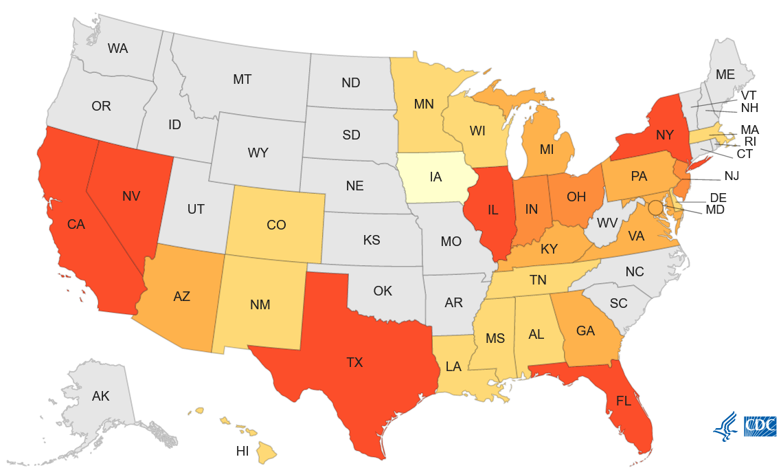 Researchers are finding that honeybees collect, along with pollen and nectar, a huge range of information about an area's health. "As they navigate through their environment, microorganisms and other tiny particles can also cling to the bees’ fuzzy little bodies, which the pollinators then shed as they enter their hives. And since pollinators tend to forage within a mile radius of their hives in urban areas, there’s valuable information about a city or even a neighborhood in the honey they produce, on their bodies and in the debris that lies at the bottom of hives. ... The new research aims to establish a feasible method for collaborating with beekeepers and their colonies of honeybees for the purpose of studying the microbiome of cities." www.bloomberg.com/news/articles/2023-03-30/honeybees-are-predictors-of-a-city-s-health-new-research-finds
Scientists associated with China's Institute of Oceanology have deployed a long-term ocean observation platform to study cold seeps in the South China Sea. What are cold seeps, you might ask? This useful pair of videos from the U.S. National Oceanic and Atmospheric Administration (NOAA) explains what a cold seep (also known as a methane seep) is, what a hydrothermal vent is, and how they are different: oceanexplorer.noaa.gov/facts/seeps-vents.html
The cherry blossoms near the Jefferson Memorial in Washington, DC, are at peak bloom now. If you can't get to Washington, DC, you can still see them via this live bloom cam: www.bloomcam.org/ Prefer to check in on Japan's cherry blossoms? Try this live bloom cam: https://www.youtube.com/watch?v=7P9DlrY8xXc
Whiskey fungus is a microbe that feeds on ethanol, particularly airborne ethanol. It is commonly found around breweries, bakeries, and distilleries. As Jack Daniel's has expanded its warehouses for aging whiskey, whiskey fungus has expanded its range in rural Tennessee as well, setting up a clash between one of Tennessee's most famous products and residents who complain of a sooty mold overtaking their property. www.nytimes.com/2023/03/01/us/whiskey-fungus-jack-daniels-tennessee.html
|
Blog sharing news about geography, philosophy, world affairs, and outside-the-box learning
Archives
December 2023
Categories
All
|
 RSS Feed