|
COVID and geopolitics have played a role in the shifting composition of international students at U.S. colleges and universities. This geo-graphic from Statista looks at international student enrollment, at the undergraduate and graduate levels, across the U.S.: www.statista.com/chart/20010/international-enrollment-in-higher-education/
0 Comments
This quiz contains several questions about lesser-known aspects of North America that, if you get them wrong, might make for a fun learning diversion: play.howstuffworks.com/quiz/can-you-pass-this-difficult-north-american-geography-quiz (The quiz also contains at least one mistake. Let me know if you spot it.)
Due to a powerful solar storm, there have been great photos of the aurora borealis spotted in unlikely places this week, including as far south as Missouri. If you'd like to catch the aurora, the U.S. National Oceanic and Atmospheric Administration (NOAA) provides a daily forecast and notes the aurora "does not need to be directly overhead but can be observed from as much as a 1000 km away when the aurora is bright and if conditions are right." www.swpc.noaa.gov/products/aurora-30-minute-forecast
The Darién Gap is a roadless region of tropical rainforest connecting North and South America; the "gap" refers to the gap in the Pan-American Highway in this section of southern Panama and northern Colombia. Since the economic disintegration of Venezuela in 2018, the Darién Gap has also emerged as a primary, if arduous, transit corridor for migrants trying to get from South America to Mexico and the U.S. This article from the New York Times looks at the how the Darién Gap has become a major cash cow, not just for smugglers but also for entrepreneurs and local officials in what is effectively a space outside central government control. Trafficking migrants across the Darién Gap is described as "the only profitable industry in a place that didn’t have a defined economy before.” www.nytimes.com/2023/09/14/world/americas/migrant-business-darien-gap.html
Most people are familiar with the concept of life expectancy. Less familiar are the many variants on life expectancy, including "healthy life expectancy" (HALE), which is defined by the World Health Organization as the "average number of years that a person can expect to live in 'full health' by taking into account years lived in less than full health due to disease and/or injury." This map shows the countries with the largest gap between life expectancy and healthy life expectancy -- or, thought of another way, with the most years of unhealthy old age -- as of 2019. The U.S. tops the list, with a gap of 12.4 years, followed by Australia, at 12.1 years. Completing the top 10 are New Zealand, the UK, Norway, Spain and Italy (tied), Iran, and Canada, Kuwait, and Switzerland (tied). 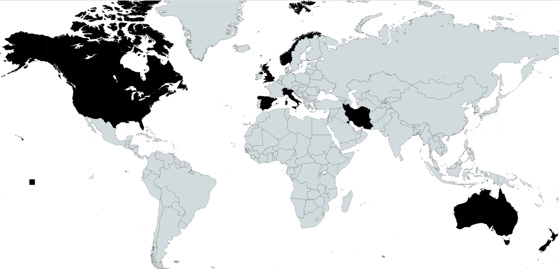 This map shows the peak range of woolly mammoths using both a Fuller or Dymaxion map projection and a conventional (Mercator-like) map projection. Buckminster Fuller created the Dymaxion projection in the 1940s to better preserve the sizes and shapes of landmasses. brilliantmaps.com/woolly-mammoths
Last week's smoky air has dissipated on the East Coast, but this is almost certainly not the last time you will find yourself wondering about air quality. The Environmental Protection Agency's AirNow map shows air-quality data, updated hourly: gispub.epa.gov/airnow/?monitors=pm (You can select for ozone, particulate matter, or both.)
This map, from data provided by the Canadian Interagency Forest Fire Centre, shows where wildfires are burning, uncharacteristically early, in Canada. Many of these fires are contributing to poor air quality in Canada and the U.S. (Map appeared in www.wsj.com/articles/air-quality-levels-drop-in-u-s-as-smoke-billows-from-canadian-wildfires-c87c53db.)
This article from Fortune introduces readers to Gatun Lake, a body of water you may have never heard of or thought about that is poised to play a huge role in global trade, supply chain management, and inflation because of a severe, ongoing drought in Panama:
"Federal Reserve Chair Jerome Powell keeps careful track of employment levels, wages, consumer prices and numerous other metrics to see where the US inflation rate may be headed in the next year. He might also want to keep an eye on water levels at Gatun Lake. That’s the lake that feeds the locks in the Panama Canal with the fresh water needed to raise vessels as they pass from the Pacific Ocean to the Atlantic. But a severe drought has caused water levels in the lake to drop far below normal, resulting in weight limits and rising surcharges for vessels traversing the canal. It’s also unnerving economists and supply-chain experts. Just as the world’s delivery bottlenecks are easing, Panama’s drought and worrisome weather patterns elsewhere threaten to revive some of the chaos of 2021, when a surge in shipping costs and consumer demand resulted in shortages of goods, helping to drive US inflation to a four-decade high. If Gatun Lake levels keep falling as forecast, the market reaction will be higher shipping rates and a scramble to find alternative routes from Asia to the US, logistics experts said. ... Making matters worse, an El Niño system is building in the western Pacific Ocean and is expected to upset normal weather patterns by the end of this year. While this can cause heavy rainfall in some regions, in Panama it typically means severe drought and higher than normal temperatures." fortune.com/2023/06/02/panama-canal-water-levels-drought-inflation/ Landmines often persist long after a conflict ends. This map, based on data from an NGO that monitors landmines and operations to clear them, shows where landmines still exist, more than 25 years after a UN treaty that bans their use: cdn.statcdn.com/Infographic/images/normal/26209.jpeg
NASA has released this map showing the world's major carbon dioxide emitters (in brown, with 3D shading) and absorbers (in green) from 2015-2020. Because this map is based on data collected by satellite, it includes measures for countries that have not reported emissions data in years. The major carbon-absorbing countries have large swaths of forest, particularly the taiga (or boreal forest) of Canada and Russia. news.yahoo.com/nasa-map-shows-which-countries-are-releasing-and-absorbing-co2-123341959.html
This graphic from Statista, based on data from the U.S. Customs and Border Protection, shows the changing composition of undocumented migrants apprehended at the southern U.S. border over the last 20+ years, from largely Mexican citizens to largely people from countries other than Mexico. Over the last year, more than two-thirds of the non-Mexican migrants were NOT from Central America. www.statista.com/chart/20326/mexicans-non-mexcians-apprehended-at-southern-us-border
Working on behalf of a free press and the public's right to know is often a dangerous job. War zones figure into this map showing where the most journalists were killed in 2022, but Mexico continues to be the most dangerous place to be a journalist: cdn.statcdn.com/Infographic/images/normal/1181.jpeg
Which countries have the largest share of their populations living abroad? It turns out island nations -- nearly one out of three Polynesians is living outside of their home country, for example -- and, not surprisingly, countries with stagnant economies and/or conflict are high on the list. This geo-graphic from Statista looks at the top 8 countries (min. population size 750,000) and a sampling of others: www.statista.com/chart/4237/the-countries-with-the-most-people-living-overseas
A large high-pressure zone over Greenland is expected to create a phenomenon known as the "Greenland block," so named because it blocks the usual path of the Northern Hemisphere's jet stream, later this month. A Greenland block redirects the jet stream southward, often creating colder (and often wetter) conditions on the East Coast of the U.S. Most of the Washington, DC area's biggest snowstorms, including the 2009 "Snowpocalypse" storm that dumped about two feet of snow in 24 hours, resulted from a Greenland block. www.washingtonpost.com/weather/2022/11/29/greenland-block-snow-dc-midatlantic/
If you've been hiking at or above the tree line in the Sierra Nevadas, Pacific Northwest, or northern Rocky Mountains, you have probably passed a whitebark pine tree; these are often the highest-elevation pine tree found in these areas. But the whitebark pine is being decimated by a nonnative fungus and a native beetle that is benefiting from warming temperatures, contributing to the tree's current consideration for protection under the Endangered Species Act. This article from the Cornell Lab of Ornithology discusses the biogeographic interplay between the whitebark pine and Clark's nutcracker, a bird that both depends on the whitebark pine and is critical for the dissemination of whitebark pine seeds: www.allaboutbirds.org/news/can-the-clarks-nutcracker-help-its-bff-the-whitebark-pine-recover-from-disaster
The Darién Gap is the southernmost section of Panama that is part Panamanian rainforest and national park, part indigenous land, and part ungoverned space in which a variety of gangs and smugglers have long held sway. The "gap" refers to a gap in the Pan-American Highway: there is no road through the Darién Gap to connect Panama with Colombia. Over the last few years, the Darién Gap has become a route for Venezuelan and other migrants heading to the U.S. (many of whom fly into Ecuador from around the world to take advantage of Ecuador's liberal visa policy). This article from The New York Times chronicles the hazards of the Darién Gap: www.nytimes.com/2022/10/07/world/americas/venezuelan-migrants-us-border.html
The second major named storm of the Atlantic hurricane season has just made its way across Cuba and Florida. This map, based on the INFORM Risk Index, looks at the risk of hurricane-related humanitarian crises in Latin America and the Caribbean: cdn.statcdn.com/Infographic/images/normal/28317.jpeg
The Economist (UK) ranked 172 cities around the world for livability, based on more than 30 factors related to stability, education, health care, infrastructure, culture, and environment. In North America, the four most livable cities were all in Canada this year, with Calgary edging out Vancouver. In the U.S., this year's most livable city was Atlanta, followed by Washington, D.C. and Honolulu. www.economist.com/graphic-detail/2022/08/05/the-best-places-to-live-in-north-america
Soil composition is a vital but often-neglected component of physical and biogeography. Like the American Midwest, Ukraine and southern Russia have some of the world's most productive soil, called chernozem (in Eurasia and Canada) or mollisol (in the U.S). This article from Science News looks at ways in which war has a lasting impact on the underlying soil chemistry, hydrology, structure, and physical composition: www.sciencenews.org/article/ukraine-russia-war-soil-agriculture-crops. (For a map that shows soil types around the world, check out this one from the USDA: https://www.nrcs.usda.gov/wps/portal/nrcs/detail/soils/use/?cid=nrcs142p2_054013.)
Researchers have "mapped the location and density of Earth’s irrecoverable carbon — carbon locked in ecosystems that is potentially vulnerable to release from human development and, if lost, could not be restored to those ecosystems by 2050." This irrecoverable carbon, mostly residing in forests, peatlands, mangroves, and other natural areas, has been described as "the carbon we must protect to avert climate catastrophe." www.sciencenews.org/wp-content/uploads/2021/11/111821_jl_carbon_inline_desktop_rev.png (Map and quotes from www.sciencenews.org/article/climate-change-natural-carbon-stores-new-map)
Although Barbados achieved independence in 1966, the island elected to remain a constitutional monarchy with Britain's Queen Elizabeth II as its titular head. Only recently, 55 years later, did Barbados choose to become an independent republic (while remaining part of the Commonwealth). This map from Statista shows countries that used to be part of the British Empire: www.statista.com/chart/26297/countries-gained-independence-from-the-uk/
Conservationists are trying to safeguard the region of the Arctic Ocean that will be the most likely to persist as frozen ice according to climate models. This Last Ice Area, as it is being called, stretches from northwestern Greenland into the Canadian Arctic Archipelago and may serve as a refuge for organisms that depend on sea ice, from polar bears to fish and crustaceans to microbes. www.sciencenews.org/article/arctic-last-ice-area-climate-change
According to a recent report by the International Work Group for Indigenous Affairs, an estimated 4.3 million Americans (corresponding to 1.3% of the U.S. population) is Native American. In Bolivia, by contrast, nearly half of the population is indigenous. www.statista.com/chart/19633/countries-by-indigenous-population-in-the-americas
This map compares the per capita GDP (adjusted for purchasing power parity) of Mexico's 32 states with countries with equivalent per capital GDPs. (The darker the color, the higher the per capita GDP.)
www.reddit.com/r/MapPorn/comments/q3ozzq/mexican_states_as_countries_by_gdp_per_capita_ppp/ |
Blog sharing news about geography, philosophy, world affairs, and outside-the-box learning
Archives
December 2023
Categories
All
|
 RSS Feed