|
This geo-graphic from Statista looks at which metro areas have the most installed data farm capacity: www.statista.com/chart/31372/regions-cities-with-highest-data-center-power-capacity
0 Comments
Perhaps not surprisingly given the composition of this year's COP climate conference participants, the first major announcement out of the conference did not address CO2 emissions, instead focusing on methane emissions. Methane emissions are a big deal, but for the fossil fuel industry, methane accounts for only about 15% of total greenhouse gas emissions. Much of the industry's methane emissions come at the site the fossil fuel is mined/drilled. This map of China shows that the country's coal mines are, themselves, methane "super-emitters," even before the coal is burned and produces CO2 emissions. (Map from www.washingtonpost.com/climate-environment/2023/12/01/china-methane-coal-mines-climate/.)
COVID and geopolitics have played a role in the shifting composition of international students at U.S. colleges and universities. This geo-graphic from Statista looks at international student enrollment, at the undergraduate and graduate levels, across the U.S.: www.statista.com/chart/20010/international-enrollment-in-higher-education/
Redevelopment in Mumbai is replacing some of the megacity's first housing, the "chawls," cheap tenement housing that has long served as an affordable entry point for new arrivals in the city. "The development of Mumbai’s chawls tells a story whose outline is common to many megacities. The buildings sprang up during the British Raj, a time when new urban jobs were luring people in their thousands away from the countryside for work in textiles or as dockworkers in one of the busiest ports in Britain’s global empire. The growth of chawls can be thought of almost as synonymous with the expansion of the city. Before Bombay became a key harbor for trade and the British navy, the region was inhabited by small fishing communities. This transformation was powered partly by events in North America, as textile manufacturing boomed when the US Civil War cut off transatlantic cotton exports to Europe.This boom fueled a desperate need for cheap housing, and chawls were a common answer. Typically built around a central courtyard, the chawls grouped rooms around a corridor, divided into either single or double room units, with bathrooms usually shared between the residents of each floor. This arrangement would perhaps have been ample with one or two workers per unit. In practice, this was never how they were used in India, where multiple generations — uncles, aunts, grandparents and cousins — shared space. ... Yet the chawls still offered (and continue to offer) benefits. Their density and grouping around courtyards — which still today continue to be the focus of activities like community sports, religious festivals and weddings — helped to generate camaraderie and community spirit between households. For low-income families in an expensive city, they offer a semblance of a safety net that the state doesn’t provide. The solidarity they generate is especially helpful for those needing help with child-care or in creating opportunities to socialize for older residents." www.bloomberg.com/news/features/2023-11-01/mumbai-chawl-tenements-helped-build-the-megacity-but-they-are-under-threat
This article from Geographical (UK) explores the physical and cultural geography of China: geographical.co.uk/culture/geo-explainer-the-many-chinas
The northern Japanese island of Hokkaido is home to both black bears and bigger, more assertive brown bears known as Ussuri bears. With declining birthrates and more people moving to cities, rural areas of Hokkaido are increasingly sparsely populated, and with fewer people, bears are moving in. To deter bears from coming into populated areas, the community of Takikawa is supplementing fencing and dogs with giant robot wolves. geographical.co.uk/news/robot-wolf-keeps-bears-away
Of the roughly 225 hostages Hamas captured in Israel and is holding in Gaza, 54 are Thai nationals. Thai nationals also make up the largest group of foreigners killed by Hamas on Oct. 7. This article from Quartz looks at issues surrounding the prevalence of Thai migrant workers in Israel's agricultural sector: qz.com/why-so-many-hamas-hostages-are-from-thailand-1850963541
When looking at a world map, it is easy to overlook that North Korea and Russia have a small -- roughly 11-mile long -- land border, shown on this map from the BBC (UK). The only transportation route in this border region is a single railway bridge over the Tumen River that separates the two countries. A surge of rail traffic across this bridge recently has suggested to observers that North Korea is sending munitions to Russia (and Russia is thought to be sending oil back across the bridge in return).
ichef.bbci.co.uk/news/976/cpsprodpb/162EA/production/_97685809_060917russnk.png.webp October is considered the best time of year to visit China's stunning Red Beach in Panjin, northeast of Beijing. The Red Beach is really a wetlands, not a beach, and the red vegetation that gives the site its name is seepweed, a kind of marsh grass, that sprouts green and becomes increasingly crimson throughout the summer as it soaks up salts in the soil. The Red Beach is an important breeding ground for the highly endangered red-crowned crane, a cultural icon throughout East Asia. www.atlasobscura.com/places/red-beach
Russia has long resisted Chinese involvement in Arctic issues, considering the Arctic to be Russia's special domain. Since Russia's invasion of Ukraine, though, Russia has started to allow China access to Arctic sea routes to transport Russian oil to Chinese markets. This map, from the Wall Street Journal, shows Russian oil shipments to China via the Arctic since July 15. (Map from www.wsj.com/world/china-is-gaining-long-coveted-role-in-arctic-as-russia-yields-f5397315.)
The Scarborough Shoal in the South China Sea was in the news again last week: members of the Philippines coast guard took a fishing boat to the area near the shoal, where China had installed a "floating barrier" patrolled by Chinese vessels, impeding Filipino fishing boats from accessing the waters near the shoal, and cut the line. Chinese officials later denied the line had been cut, saying they had chosen to remove it. But for the people of the Philippines, the incident has been cast as a David-and-Goliath story, with Philippine president Ferdinand Marcos Jr. making an explicit decision to use the coast guard to defy Chinese efforts to claim the Scarborough Shoal. www.reuters.com/world/asia-pacific/philippines-remove-barrier-placed-by-china-south-china-sea-national-security-2023-09-25/
Nickel is a key mineral in batteries, a pivotal component in green energy technologies, and Indonesia has the world's largest nickel reserves, centered on the monkey-shaped island of Sulawesi. But Chinese investment in smelting and refining Indonesia's nickel is putting it at the center of a geopolitical tug of war.
"Mr. Luhut [an Indonesian cabinet minister] aspires to transform Indonesia into a hub for the production of electric vehicles. But as he pursues that paramount goal, he and his country are increasingly vulnerable to geopolitical forces beyond their control. Though this archipelago nation has long sidestepped entanglements in ideological rivalries, it is increasingly caught in the conflict between the United States and China. At stake is control over nickel, a mineral used to make batteries for electric cars and motorcycles — a central component of the mission to limit the ravages of climate change. Indonesia boasts the earth’s largest reserves, making it something like the Saudi Arabia of nickel. But harvesting and refining those stocks is largely dependent on investment and technology from Chinese companies. And that has limited Indonesia’s access to the United States. ... In recent months, Mr. Luhut — formally Indonesia’s coordinating minister for maritime affairs and investment — has implored the Biden administration for a trade deal covering minerals in an effort to secure his country status as a friendly country. That would generate greater demand for its nickel by making it eligible for the American tax credits under the Inflation Reduction Act. Companies around the globe would presumably gain incentive to erect smelters and electric vehicle factories in Indonesia, enhancing the nation’s technological prowess, and creating jobs. But Mr. Luhut, the government’s de facto lead official on trade matters, has been repeatedly rebuffed because of American concerns about Chinese investment in Indonesia’s nickel industry, as well as unease over working conditions and environmental standards. ... “We are aiming basically to the United States,” he said. “But if the Americans finally say, ‘We don’t want to take it,’ fine, we’ll look for some other places to go.”"www.nytimes.com/2023/08/18/business/indonesia-nickel-china-us.html Fast forward to 2050: this geo-graphic from Statista looks at the anticipated number of retirees per 100 working people, in selected countries, in 2020 vs. 2050. Numbers in 2050 range from 40.4 retirees per 100 working people in the U.S. to 80.7 (!) retirees per 100 working people in Japan. The length of the bar highlights the change in value from 2020 to 2050. www.statista.com/chart/30831/evolution-of-the-number-of-retirees-per-100-working-people
Cantonese is the primary language of southern China, including Hong Kong, and Cantonese has been a tool for anti-regime satire and solidarity since the 2019 protests in Hong Kong. This article from Quartz looks at Beijing's attempts to crackdown on Cantonese publishing outlets and promote the teaching of Mandarin in Hong Kong's schools: qz.com/hong-kong-s-new-public-enemy-the-cantonese-language-1850780591
This map and geo-graphic from Statista looks at extreme poverty -- defined by the World Bank as a daily income of $2.15 or less -- in selected countries before the COVID epidemic. www.statista.com/chart/30742/people-living-in-extreme-poverty-country-share/
China recently indicated President Xi Jinping will skip the G-20 economic summit in India later this month. That decision comes on the heels of a new standard map released by China's ministry of natural resources last week that shows India's state of Arunachal Pradesh, in the far northeastern part of the country, and all of the Aksai Chin plateau, part of which is in Kashmir, as Chinese territory. Although the Himalayan border between India and China has been poorly defined, disputed, and the source of military conflict for decades, the new map is viewed with concern as part of a tendency for China to claim territory in print before trying to assert its claims in other ways. qz.com/india-china-border-dispute-map-arunachal-pradesh-1850786461
If you're thinking about an exotic fall getaway, September and October are usually the peak months for the Maldives' bioluminescent beaches. Vaadhoo Island at the northern end of the archipelago is the best known spot to see the "sea of stars," but this tourism piece highlights a number of other possible, and less remote, locations as well: samudramaldives.com/maldives-glowing-bioluminescence-beaches/
Indonesia has about 14,000 islands, and Bali is often thought of as the "party island." Because the windy season begins in July each year, one of Bali's key festivals during July and August is the Bali Kite Festival. Kite making and kite flying play an important role in Balinese Hindu culture, and these kites are BIG: up to 10m long and 4m wide, with tails that can exceed 100m! www.nationalgeographic.com/history/article/color-and-magic-fill-balis-skies-with-the-return-of-a-beloved-kite-festival
Two express trains collided in India's Odisha state yesterday, resulting in more than 200 deaths as of this writing. Odisha borders the Bay of Bengal, southwest of Kolkata. The trains were on the main rail line connecting the megacities of Kolkata and Chennai. The pin on this map marks the approximate location of the crash. 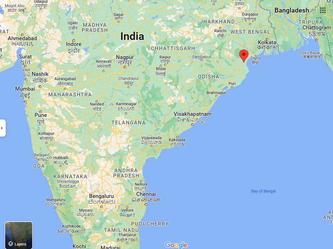 China dominates the processing of rare earth metals. But increasingly, China is importing rare earth metals for processing as domestic mining has fallen, which is spurring Chinese investment in foreign rare earth mining operations. "Rare earths are a group of 17 metals critical to many high-tech applications. ... After rare earth ores are mined, they have to be crushed and ground up to extract the metals from the minerals. Chemical procesess separate out individual rare earth elements, and further refining and alloying processes produce high-purity metals for use in manufacturing. China essentially has a monopoly on every step beyond the first phase of digging ores out of the ground. This has given it it huge sway over the global rare earth industry. But it also means that it needs vast quantities of ore, which is currently mostly mined in China, Australia, the US, and Myanmar. ... “China depends so much on imports of rare earth raw material from abroad, [and] they are painfully aware that this dependency could be used against them,” said [Thomas] Krümmer [an analyst of the rare earth market]." qz.com/china-rare-earths-raw-materials-shortage-1850232896
Although it's been widely reported that India will overtake China as the world's most populous country at some point this year, what has received less attention are the divergent trends in fertility rates within India: the birth rate in northern India is nearly twice that of southern India. In southern India, the total fertility rate is 1.8 children per woman, on a par with the U.S. and most of Europe. In northern India, the total fertility rate is about 3 children per woman, on a par with Namibia and Libya, among other countries. "Not only are southern [Indian] states providing women better access to contraceptives and family planning services, experts say, but they’re also affording women better educations, more jobs and higher relative social status — crucial, intangible factors that have led to smaller family sizes and greater prosperity. 'Demographically, we have two Indias,' said Arvind Subramanian, the Indian government’s chief economic adviser between 2014 and 2018. 'The India of the south already resembles East Asia. It’s actually in the early stages of aging. But the Hindi heartland is still very much booming.' ... The north-south gap in birthrates and overall development is stirring frequent debates about how to apportion federal spending and how to allocate seats in Parliament. It’s also sparked efforts by government leaders and development experts to provide enough jobs to the poor, northern states — and lift up women like Malika [a woman profiled in the story from the northern state of Bihar], who are left behind even as India’s surging economy looks destined to overtake Germany’s later this decade. ... According to the 2021 national family survey, 84 percent of Tamil Nadu women are now literate, compared with 55 percent in Bihar, the lowest in India. Forty-six percent of married women in Tamil Nadu were employed in the last 12 months, versus 19.2 percent of married Bihari women. ... Increasingly, India’s failure to close its north-south demographic and economic divide is leading to political consequences. In Bihar, the pressure on public-sector employment is so great that cuts to government job openings or in military recruitment often spark riots. Meanwhile, southern states such as Tamil Nadu, which is expecting to see its population decline sometime in the next decade, has seen an influx of northern migrant laborers, occasionally leading to friction."
www.washingtonpost.com/world/2023/04/14/india-china-population-most-populous/ Just 29 countries (shown in yellow) contribute more than half of the world's maternal deaths, newborn deaths, and stillbirths: reliefweb.int/map/world/map-2023-countries-un-humanitarian-appeals-contribute-global-maternal-deaths-newborn-death-and-stillbirths
Landmines often persist long after a conflict ends. This map, based on data from an NGO that monitors landmines and operations to clear them, shows where landmines still exist, more than 25 years after a UN treaty that bans their use: cdn.statcdn.com/Infographic/images/normal/26209.jpeg
The AidData lab at the College of William & Mary has found 22 countries that have relied on often-opaque emergency lending from China since 2000, either via liquidity swaps with China's central bank or lines of credit from state-owned Chinese banks. This emergency lending is often at higher interest rates than emergency loans from the IMF, for example, and may not be recorded as external debt, concealing a country's actual debt load. www.statista.com/chart/29603/chinese-emergency-bailouts
Scientists associated with China's Institute of Oceanology have deployed a long-term ocean observation platform to study cold seeps in the South China Sea. What are cold seeps, you might ask? This useful pair of videos from the U.S. National Oceanic and Atmospheric Administration (NOAA) explains what a cold seep (also known as a methane seep) is, what a hydrothermal vent is, and how they are different: oceanexplorer.noaa.gov/facts/seeps-vents.html
|
Blog sharing news about geography, philosophy, world affairs, and outside-the-box learning
Archives
December 2023
Categories
All
|
 RSS Feed