|
As meteorology and scientists' understanding of how disparate global weather patterns are connected continue to improve, this piece argues that El Niños are now predictable events and that there is no reason why the problems they cause should continue to take policymakers by surprise. www.nytimes.com/2023/10/29/opinion/el-nino-climate-disaster.html
0 Comments
Perhaps not surprisingly given the composition of this year's COP climate conference participants, the first major announcement out of the conference did not address CO2 emissions, instead focusing on methane emissions. Methane emissions are a big deal, but for the fossil fuel industry, methane accounts for only about 15% of total greenhouse gas emissions. Much of the industry's methane emissions come at the site the fossil fuel is mined/drilled. This map of China shows that the country's coal mines are, themselves, methane "super-emitters," even before the coal is burned and produces CO2 emissions. (Map from www.washingtonpost.com/climate-environment/2023/12/01/china-methane-coal-mines-climate/.)
Above ground is not the only place to live. Historically, some communities have lived underground for safety, most prominently the complex near Derinkuyu, Turkey that is thought to have supported a community of 20,000 people and their livestock underground. In the Australian Outback and, more recently, in southwestern China, people have started living underground to escape the heat. This article looks at Coober Pedy, an underground community in and around abandoned opal mines in Australia: www.bbc.com/future/article/20230803-the-town-where-people-live-underground
Drought in the Midwest is leading to lower water levels in the Mississippi River again this year, which is leading to salt water encroaching up the river and threatening the water supplies of New Orleans. Although the "saltwater wedge" isn't supposed to arrive for a couple of weeks, New Orleans residents are starting to empty grocery stores shelves of bottled water.
"The crisis is a result of drought conditions in the Midwest, which have sapped water levels in the Mississippi, allowing salty water from the Gulf to creep upstream beneath a freshwater layer. Officials with the U.S. Army Corps of Engineers say the “saltwater wedge,” which has already affected communities downstream, could reach water treatment plants near New Orleans in about a month, pushing the salty water into household faucets. About a million people across southeastern Louisiana could be affected. Officials are working to slow the influx by strengthening an underwater sill, or levee, at the bottom of the Mississippi, and preparing to ship tens of millions of gallons of fresh water from upstream by barge to affected treatment facilities on a daily basis. Still, managing the demand for clean water could take a herculean effort, Dr. [Jesse] Keenan [of Tulane University] said, especially because it is unclear how long the intrusion could last. City officials said this week that they were planning for as long as three months, based on expert advice. In previous dry years, including in 1988 and 2012, officials in Louisiana managed to avert major problems, but this could be different: It’s the second straight year in which water levels have dropped drastically because of heat and drought intensified by climate change." www.nytimes.com/2023/09/29/us/new-orleans-saltwater-intrusion.html This map, from The Wall Street Journal, shows global ocean temperatures from mid-July to mid-August as compared with historical averages (red=hotter, blue=colder). The map is used in the context of an article discussing how warming oceans and migrating sea life are forcing changes in fishing and allied industries (from www.wsj.com/us-news/climate-environment/heating-waters-force-change-in-industries-that-depend-on-the-ocean-efd471d6).
The tropical storm that delivered record rains to Southern California and parts of the Southwest earlier this week was fueled, in part, by the return of an El Niño weather pattern. This article from Foreign Policy looks at what El Niño means, not just for local weather but also for food security, armed conflicts, disease outbreaks, territorial claims, and other geopolitical concerns: foreignpolicy.com/2023/08/18/el-nino-forecast-weather-season-global-impact-conflict-food-supply-health-disease
This series of maps and images compares current vistas around the world with images predicting how those same vistas might change based on a 1.5°C increase in global temperatures and a 3°C increase in global temperatures: picturing.climatecentral.org/
It's impossible to avoid the heat and drought stories this summer. This one is about Iran and how extreme water scarcity is shaping political protest, basic livability -- two provinces are expected to run out of municipal water completely by September -- and the geopolitics of the region. www.nytimes.com/2023/07/23/world/middleeast/iran-heat-water.html
AMOC (pronounced "ay-mock")-- the Atlantic Meridional Overturning Circulation -- is a network of Atlantic Ocean currents, including the Gulf Stream, that plays a pivotal role in keeping Western Europe warm relative to its latitude and distributing heat around the planet. Multiple studies have found AMOC is weakening and is now perhaps the weakest it has been in 1,000 years. The massive melting of the Greenland ice sheet, which is dumping an estimated 250 billion metric tons of ice and cold, fresh meltwater into the northern Atlantic each year, is eyed as a possible culprit. Last week a study by Danish researchers of 150 years of weather data concluded that AMOC could collapse -- as it did 12,800 years ago -- by the end of the century, perhaps even within a few years. This article from Scientific American explains the science, the unknowns, and AMOC's significance: www.scientificamerican.com/article/is-a-mega-ocean-current-about-to-shut-down/.
As extreme heat grips much of the world, Death Valley, CA seems to have set a new record: its midnight temperature was measured at 120°F. The low a few hours later was measured at 105°F, which would also be a record if confirmed. www.newscientist.com/article/2382959-death-valley-may-have-just-had-the-hottest-recorded-midnight-ever/
Foreign policy think tanks throughout Washington, DC, host dozens of free programs, open to the public, every week on hot topics in international affairs. Tomorrow, for example, the Wilson Center is doing a free webinar (9:30-10:30 ET) on how glacier loss is threatening agriculture in both the U.S. and China. For more information or to register, see us02web.zoom.us/webinar/register/WN_6fVulOQGS2CM1MQmGRfjyg#/registration
This year is seeing a strong return to El Niño weather patterns, which is proving to be particularly damaging to Peru: higher-than-usual temperatures and rainfall are fueling a dengue fever outbreak, which has resulted in more than 140,000 cases of "bone-break fever" already this year. During the last El Niño cycle, Peru's GDP dropped about 10%. Although the problem might be worse for coastal countries like Peru, the impacts of El Niño are felt globally: in the U.S., economists have found the last couple of El Niño cycles are thought to have resulted in a 3% decline in what GDP would have otherwise been: www.cbc.ca/news/health/peru-dengue-el-nino-1.6875012
Which countries have the most extreme temperatures? This map shows countries (in red) with recorded high temperatures in excess of 48°C (or 118.4°F), countries (in blue) with recorded temperatures below -48°C (or -54.4°F), and countries (in black) that have experienced both extremes. moverdb.com/above-below-48/
Scientists have analyzed 20 years of data from a satellite that detects changes in gravity to measure fluctuations in water both at the surface and in underground aquifers to characterize and map changes in rainfall, finding extreme patterns that might not otherwise make headlines because they unfold over months, not days, and frequently are not confined to a single state or country. www.nytimes.com/interactive/2023/03/14/climate/extreme-weather-climate-change.html
Extreme drought in Argentina is expected to reduce the country's GDP by 3% this year. Because this decline comes almost entirely in the agricultural sector, significantly lower crop yields are likely to affect global prices for soybeans, corn, wheat, and other foodstuffs. www.reuters.com/world/americas/historic-drought-argentina-seen-shrinking-gdp-by-3-points-2023-03-10/
Phenology is the study of seasonal or cyclic natural phenomena, such as animal migration or the flowering of plants. The USA National Phenology Network provides a series of historic, real-time, and forecast maps related to a wide variety of plant, animal, and temperature cycles. This one looks at spring leafing anomalies (the darker the red, the earlier plants are leafing out relative to historic norms; the blue areas show delayed leafing). From www.usanpn.org/data/spring_indices 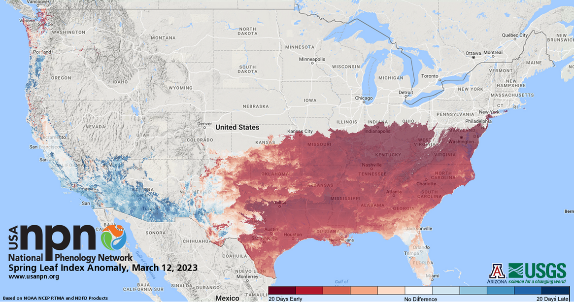 Although some locations in the U.S. have gotten massive amounts of snow this winter -- 9.7 feet in Buffalo, New York, for example, and nearly 43 feet on Mammoth Mountain in California's Sierra Nevadas -- other traditionally snowy places like Boston and Chicago have received below-average snowfall. https://www.washingtonpost.com/weather/2023/02/03/us-snowfall-extremes-map
As this map shows, thus far, the winter has proved warmer than usual in most of Europe, which has allowed natural gas and other energy prices to fall back to more normal levels. But a colder-than-usual winter in parts of Asia is creating natural gas shortages and heating problems in China, in particular. (Map from www.nytimes.com/2023/01/25/business/china-natural-gas-shortages.html.)
This article from The Washington Post provides a fascinating look at cutting-edge techniques for exploring remote places -- including the use of diving robots and sensors on animals -- as well as the significance of the Denman Glacier in East Antarctica. www.washingtonpost.com/climate-environment/2023/01/18/climate-change-glacier-antarctica/
A large high-pressure zone over Greenland is expected to create a phenomenon known as the "Greenland block," so named because it blocks the usual path of the Northern Hemisphere's jet stream, later this month. A Greenland block redirects the jet stream southward, often creating colder (and often wetter) conditions on the East Coast of the U.S. Most of the Washington, DC area's biggest snowstorms, including the 2009 "Snowpocalypse" storm that dumped about two feet of snow in 24 hours, resulted from a Greenland block. www.washingtonpost.com/weather/2022/11/29/greenland-block-snow-dc-midatlantic/
The world's tropical glaciers -- in Asia, in Africa, and in South America -- are essential sources of water for billions of people. This article looks at the looming disappearance of Africa's glaciers, due not just to warming but to drought and changing rainfall patterns across East Africa: www.washingtonpost.com/world/interactive/2022/kenya-glaciers-africa-climate-change/
Yes, climate change is making some natural disasters worse, but is it also becoming a tidy way of letting governments off the hook for bad planning? The recent floods in Pakistan are a case in point. An international team of researchers analyzed the flooding in Pakistan and found that rainfall in the southern provinces of Sindh and Balochistan was "about 75% more intense than it would have been had the climate not warmed by 1.2C." But the report also found "The devastating impacts were also driven by the proximity of human settlements, infrastructure (homes, buildings, bridges), and agricultural land to flood plains, inadequate infrastructure, limited ex-ante risk reduction capacity, an outdated river management system, underlying vulnerabilities driven by high poverty rates and socioeconomic factors (e.g. gender, age, income, and education), and ongoing political and economic instability." Although solving climate change will remain out of the purview of any single country, that does not mean governments do not need to address in-country zoning, infrastructure, economic and political issues to mitigate the impacts of climate change. www.worldweatherattribution.org/climate-change-likely-increased-extreme-monsoon-rainfall-flooding-highly-vulnerable-communities-in-pakistan/
NASA instrumentation aboard the International Space Station has pinpointed more than 50 methane super-emitters since it was installed in July, including an oilfield in New Mexico, a waste-processing complex in Iran, and massive, previously unidentified plumes associated with oil and gas facilities in Turkmenistan. The instrumentation will be in service for a year and will be tracking airborne dust to help scientists model the potential for airborne dust in different parts of the world "to trap or deflect heat from the sun, thus contributing to warming or cooling of the planet." Identifying methane sources from space, including those in locations that would otherwise be difficult to monitor, was an unexpected side benefit. www.reuters.com/lifestyle/science/nasa-instrument-detects-dozens-methane-super-emitters-space-2022-10-26/
Fog is a vital characteristic of biomes ranging from temperate rainforests to cloud forests and may even become a source of water commercially harvested for drinking. Yet scientists around the world are finding that fog, particularly along the coasts, seems to be in decline for complex reasons, including warming oceans. "Fog may be the most difficult meteorological phenomenon to capture, calculate and predict. Unlike temperature, precipitation, humidity or wind, there is no reliable gauge for it. There is not even a practical definition of it. Most will say that fog is a cloud that touches the ground, which sounds simple enough. But fog is movement in three dimensions, dipping and rising, forming and disappearing. Sometimes a thin layer hugs the water below the Golden Gate Bridge, blinding mariners. Sometimes it settles about 200 feet higher, blinding drivers. Sometimes it shrouds the top of the bridge’s towers and the airspace above, blinding pilots. Sometimes it does it all. Which of those things is fog? ... Fog from the ocean is a dependable feature in several places around the globe, mostly on the west coasts of major continents. Villages in places like Peru and Chile, sometimes with almost no rain throughout the year, have for centuries sustained themselves largely on fog water. ... Using observational data at airports in the coastal redwood region — from central California to its northern border, including the Bay Area — they found that the frequency of fog, measured by fog hours per day, had dropped 33 percent since the middle of the 20th century." www.nytimes.com/interactive/2022/09/14/climate/san-francisco-fog.html
Farmers in the Southwestern U.S. are ripping out orchards, switching to less water-intensive crops, and renting out their land to try to save water and raise money in the face of an extended drought. This map compares vegetation stress in August 2022 with the average August vegetation stress from 1984 to 2020: green is more healthy, red is more stressed. (Map from www.wsj.com/articles/drought-in-u-s-west-leads-farmers-to-look-elsewhere-for-revenue-11664535602.)
|
Blog sharing news about geography, philosophy, world affairs, and outside-the-box learning
Archives
December 2023
Categories
All
|
 RSS Feed