|
The life expectancy of Americans varies significantly based on where they live, as this map, based on pre-pandemic average life expectancies, shows. (Map and an interesting discussion of the cultural and political dynamics that underlie it at www.politico.com/news/magazine/2023/09/01/america-life-expectancy-regions-00113369.)
0 Comments
The decennial U.S. Census is a reason to redraw congressional maps in many states. This topological map, based on data from the Princeton Gerrymandering Project and the Electoral Innovation Lab, considers the level of gerrymandering baked into states' current congressional maps. (Map from www.washingtonpost.com/politics/2023/10/07/illinois-congressional-map-gerrymandering/.)
On Sunday, Türkiye (Turkey) will be holding its presidential election, and the Kurdish vote is likely to play a significant role. This map, which redraws current borders in the Middle East based primarily on dominant nationality, hints at the geographic extent of the Kurdish population in Türkiye and in neighboring countries. brilliantmaps.com/new-middle-east/
Reporters Without Borders released its 2023 World Press Freedom Index earlier this week: "180 countries and territories were analyzed based on five indicators covering political context, legal framework, economic context, sociocultural context and safety." This map shows the results: www.statista.com/chart/13640/press-freedom-index/ Worst countries for press freedom: North Korea, China, and Vietnam. Best countries for press freedom: Norway, Ireland, and Denmark.
This topological map from the Chronicle of Higher Education shows where legislation has been introduced to limit diversity, equity, and inclusion initiatives on public campuses (in aqua) and where this kind of legislation has passed (nowhere as of this writing) or been tabled or failed to pass (in brown). The interactive map will be updated regularly throughout the legislative season. www.chronicle.com/article/here-are-the-states-where-lawmakers-are-seeking-to-ban-colleges-dei-efforts
A new ban on high-capacity magazines and assault-style weapons came into effect in Illinois earlier this month, resulting in this map of states that have laws on the books for these: cdn.statcdn.com/Infographic/images/normal/18924.jpeg
The U.S. Department of State and Google Maps are now on board with Turkey's request to spell the name of the country "Türkiye." (To make the necessary ü in Word, use control-: and then the u.) 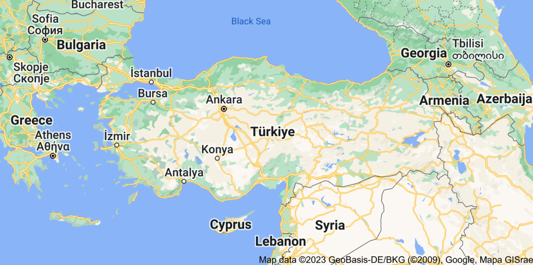 For more than 7 years, Egypt has been planning and building a new capital city 40 miles east of Cairo. New Administrative Capital, as the city is called, is not yet complete, but civil servants are being asked to move to the new capital beginning this month, in the hope that other Egyptians will follow: www.wsj.com/articles/egypt-is-spending-billions-on-a-new-capital-that-egyptians-may-not-visit-11671838772
The Cook Islands are a self-governing group of islands in the South Pacific (shown in red on this map). Formerly considered part of New Zealand, the islands have been in "free association" with New Zealand since 1965 and conduct their own foreign and defense policy. In September, the Biden administration recognized the Cook Islands as sovereign states, renewing the islands' quest to be the newest member of the United Nations and the International Monetary Fund. tinyurl.com/ywp3hwsm
According to a New York Times analysis, more than 370 candidates for U.S. Senate, U.S. House of Representatives, governor, secretary of state, and attorney general -- the vast majority of Republicans running for those running seats -- have questioned the legitimacy of the 2020 election. This topological map provides a look at where election denial has (and has not) come to dominate Republican political discourse. (Map from www.nytimes.com/interactive/2022/10/13/us/politics/republican-candidates-2020-election-misinformation.html.)
University of Chicago political scientist Robert Pape returned to the national security podcast "Intelligence Matters" last week to provide an update on his group's detailed research on political violence in the U.S. post-Jan. 6. This site includes highlights of his remarks and a link to the 40-minute podcast: www.cbsnews.com/news/rising-political-violence-in-america-robert-pape-intelligence-matters/
The U.S. has five territories -- American Samoa, Guam, the Northern Marianas Islands, Puerto Rico, the U.S. Virgin Islands -- and all five have been losing population to the mainland. This recent article from The Washington Post profiles why residents of each territory have been moving and where, on the mainland, they have been moving to: www.washingtonpost.com/business/2022/09/23/american-territories-population-loss/
Partitioned from the rest of the island when Ireland (the country) was granted independence in 1921, Northern Ireland, which is part of the UK, is the historically Protestant-majority northeastern section of Ireland (the island). However, a recent census shows that Catholics now outnumber Protestants in Northern Ireland for the first time. www.nytimes.com/2022/09/22/world/europe/northern-ireland-census-catholics-protestants.html
Banned Books Week just concluded. This map from Quartz looks at book bans by state: i.kinja-img.com/gawker-media/image/upload/f243d7078b90019860ee2c5356763ac3.jpg
Most countries around the world received an invitation for their head of state plus one guest to attend Monday's funeral of Britain's Queen Elizabeth II. There were 9 exceptions: the countries shown in black on this map were not invited at all (Russia, Belarus, Myanmar, Syria, Afghanistan and Venezuela); for the countries shown in purple (Iran, Nicaragua, and North Korea) the invitation went to the country's ambassador to the UK instead of the head of state. 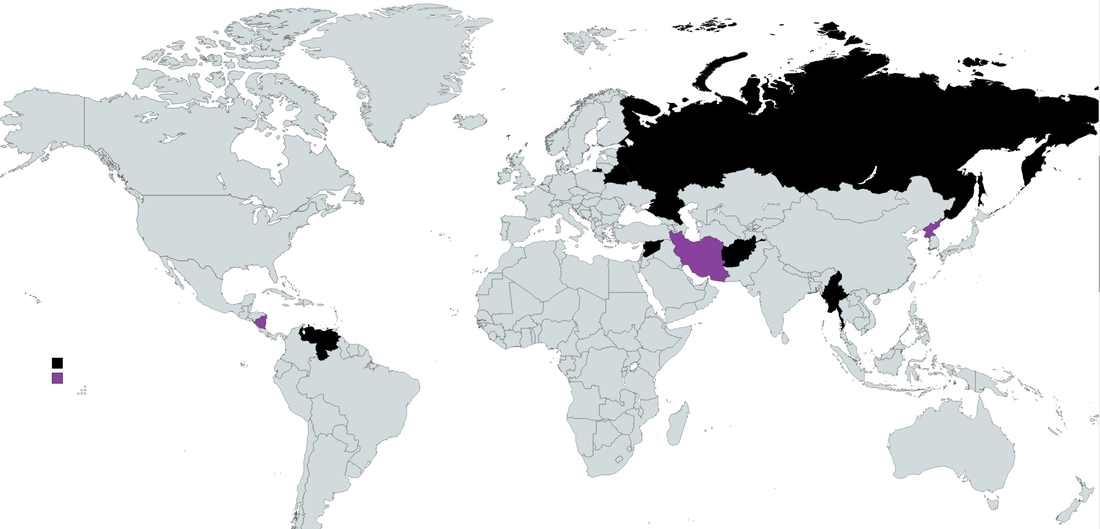 World Refugee Day was earlier this week. Although Ukrainian refugees -- now numbering 5.2 million -- have dominated the news this year, this map from Statista is a reminder that Ukrainians are just a fraction of the world's refugees: www.statista.com/chart/18436/total-number-of-refugees-by-origin-country
Based on existing laws and the current political landscape, the Center for Reproductive Rights estimates this is what the legal status of abortion would look like in the United States if Roe v. Wade is overturned this summer: cdn.statcdn.com/Infographic/images/normal/26955.jpeg (map from Statista)
Tomorrow, French voters will go to the polls to choose between current president Emmanuel Macron and perennial far-right challenger Marine Le Pen. This geo-graphic from Statista shows where right-wing populist parties have had the most electoral success in Europe: www.statista.com/chart/20094/national-election-success-of-far-right-parties-europe (For those who cannot make out the flags to the left of the bars, the top three countries shown are Hungary, Poland, and Switzerland.)
If one is in the U.S. or its democratic allies (with the notable exception of Israel and India), it might seem as if the world is all but united against Russia and its invasion of Ukraine. But, in fact, most of the world's 195 countries have not joined in sanctions or provided assistance to Ukraine, and a few have actively provided assistance to Russia. This map looks at how countries voted on the UN resolution condemning Russia's invasion of Ukraine. (Map from www.nytimes.com/2022/04/18/briefing/russian-invasion-response-world-sanctions.html.)
Historically, spring has been a busy time for home sale listings. Does the name of your street matter in terms of resale value? A recent study by a finance professor at Emory University analyzed nearly 6,000 home sales across 35 states from 2001-2020, comparing houses sold on streets with Confederate names (e.g., Jefferson Davis, Dixie) with comparable houses sold on streets without the Confederate association. The economic geography was striking in two ways. First, in the 11 states of the former Confederacy, the difference in sales prices was not statistically significant, but in the other 24 states, houses on Confederate-named streets sold for an average of 4% less -- a loss of $10,000 on a $250,000 house, for example. Second, in areas with higher shares of college educated, Democratic-voting, or Black residents, houses on Confederate-named streets sold at a bigger discount and were more likely to be slow to sell. This map shows Confederate street names in New Orleans, for example, where the city council is reconsidering place names with Confederate associations: bloximages.newyork1.vip.townnews.com/nola.com/content/tncms/assets/v3/editorial/f/ab/fab4b190-acfc-11ea-b1a5-f38812a04d2a/5ee436e73a7b7.image.jpg?resize=1333%2C1294. (Map from NOLA.com; study data from www.bloomberg.com/news/articles/2022-02-08/confederate-street-names-can-bring-lower-home-prices.)
The Economist (UK) recently released its annual look at the state of democracy around the world. Statista created a map based on this Global Democracy Index: cdn.statcdn.com/Infographic/images/normal/18737.jpeg
The anti-corruption NGO Transparency International has released its latest report. The interactive map shows 2021 corruption perceptions scores around the world. Click on a country to see the current corruption score, the corruption trend line since 2012, and news about anti-corruption initiatives. www.transparency.org/en/cpi/2021/
Indonesia is officially moving its capital from Jakarta: earlier this week the Indonesian legislature authorized building a new capital, Nusantara, on the island of Borneo. This map from Statista looks at other national capitals that have moved (and why): cdn.statcdn.com/Infographic/images/normal/25119.jpeg
According to the Dutch VPN service Surfshark, more than 1/3 of the world's countries (71 total) have blocked or restricted internet access since 2015. This map shows, in orange, the countries that are currently blocking internet access (China, Iran, Turkmenistan, and North Korea) and, in red, those that have done so at some point since Jan. 2015: surfshark.com/wp-content/themes/surfshark/assets/img/social-media/social-media-access-min-upd1207.png For the full report, see surfshark.com/social-media-blocking
Although Barbados achieved independence in 1966, the island elected to remain a constitutional monarchy with Britain's Queen Elizabeth II as its titular head. Only recently, 55 years later, did Barbados choose to become an independent republic (while remaining part of the Commonwealth). This map from Statista shows countries that used to be part of the British Empire: www.statista.com/chart/26297/countries-gained-independence-from-the-uk/
|
Blog sharing news about geography, philosophy, world affairs, and outside-the-box learning
Archives
December 2023
Categories
All
|
 RSS Feed