|
Conservationists are trying to safeguard the region of the Arctic Ocean that will be the most likely to persist as frozen ice according to climate models. This Last Ice Area, as it is being called, stretches from northwestern Greenland into the Canadian Arctic Archipelago and may serve as a refuge for organisms that depend on sea ice, from polar bears to fish and crustaceans to microbes. www.sciencenews.org/article/arctic-last-ice-area-climate-change
0 Comments
Armadillos are on the move. The nine-banded armadillo is native to Central and South America but was recorded in Texas, where it is the state mammal, as early as 1849. It has continued to expand its range in the U.S. ever since. Some towns in western North Carolina, for example, recently claimed to be "besieged" by armadillos. This map shows where the nine-banded armadillo has been observed in North Carolina over the last 15 years: www.ncwildlife.org/Portals/0/Learning/images/Species/Mammals/Map-Armadillo-Sightings-2007-2020-Cumulative.jpg
This animated cartogram, based on NASA satellite data, shows the earth's carbon capture via terrestrial plant production throughout the year: worldmapper.org/natures-heartbeat
This article from Atlas Obscura takes a look back at "turkey drives" when that was the only way, before refrigerated transport, to get one's flock to market. "When we think back on livestock migrations, we typically think of cattle, maybe sheep. The image of a rugged herdsman driving a clucking, head-bobbing, beady-eyed gaggle of birds across open plains and down dirt roads is harder to imagine, yet this practice used to be common all over the world. ... Such drives were no trivial matter, either: Birds by the thousands were sometimes driven hundreds of miles over several days; foxes and other predators would thin the herd along the way. In some parts of the world, such drives lasted into the 1930s. ... Turkey drives could include 'shooers' who herded the turkeys, children who scattered feed in the path to guide the birds, and covered wagons filled with grain to feed them. ... 'Wherever they are when the sun sets, that’s where they perch for the night,' Peter Gilbert, chair of the Vermont Humanities Council told Vermont Public Radio. 'And their collective weight shatters trees; occasionally birds end up perching on a farmer’s shed or barn and the building collapses. In fact, in one town, they roosted on top of the school building and the school collapsed.' Sometimes the turkeys would mistake the shade cast by a covered bridge for nighttime and react accordingly, requiring their drivers to roust them from the structure." Be sure to check out the photos in the article: www.atlasobscura.com/articles/back-when-your-thanksgiving-dinner-walked-hundreds-of-miles-to-market
Biogeography includes the geographic range of microbes, and the virus that causes COVID, SARS-CoV-2, now seems to be taking up residence in U.S. white-tailed deer populations. A recently published study found that 30% of the white-tailed deer tested in Iowa from Apr. through Dec. 2020 were infected with SARS-CoV-2, with 80% testing positive during the parallel surge in Iowa's human population last winter. Genetic analysis revealed the deer were being infected by the same variants circulating in humans at the time. These findings suggest white-tailed deer are becoming a wild reservoir for the virus in North America, making eradication all but impossible and raising the possibility of new mutations that evolve in deer and spillover into livestock and back into humans. www.npr.org/sections/goatsandsoda/2021/11/10/1054224204/how-sars-cov-2-in-american-deer-could-alter-the-course-of-the-global-pandemic
This New York Times article highlights an important aspect of cultural geography in central Africa: the role of cows, as wealth, as status, and as an important nutritional source. In Rwanda, milk is the drink of choice in bars, hot or cold, fresh or fermented. www.nytimes.com/2021/10/09/world/africa/rwanda-milk-bars.html
Melbourne, Australia, just finished the world's longest COVID lockdown to date. This geo-graphic shows cumulative days of COVID lockdowns by various jurisdictions around the world: www.statista.com/chart/26023/areas-with-the-longest-cumulative-pandemic-lockdowns. (It is expected that the emergence of the so-called Delta-plus variant in the UK may result in one or more of the UK's subdivisions passing Melbourne in the not-too-distant future.)
Carbon dioxide accounts for roughly half of the increase in global temperatures observed over the last 250 years. But methane -- a byproduct of agriculture, oil/gas production, and waste management practices -- accounts for nearly a quarter of the rise in global temperatures. This map from Bloomberg shows how the primary contributors of methane vary by country and region. (For more on this issue, including more maps and a look at the chemistry of CO2 vs. methane see the original article: www.bloomberg.com/graphics/2021-methane-impact-on-climate/)
The geo-graphics in this article, including this one, for example (static01.nyt.com/images/2021/09/27/multimedia/27-MORNING-sub2-STATE-VAX-VOTE-PLOT/27-MORNING-sub2-STATE-VAX-VOTE-PLOT-superJumbo.png), highlight the increasingly clear relationship between political geography and COVID vaccination rates and death rates in the U.S.: www.nytimes.com/2021/09/27/briefing/covid-red-states-vaccinations.html
Earlier this week researchers announced the completion of the Allen Coral Atlas, the first ever interactive mapping tool of the world's shallow coral reefs. Building on the work of more than 450 research teams and nearly 2 million satellite images, the atlas is named for the late Microsoft co-founder and philanthropist Paul Allen who was an early supporter of the project. allencoralatlas.org/atlas/#6.00/20.1359/-155.5908
Although COVID infections seem to again be tailing off in the U.S., they are still raging in countries like Vietnam, which is not only a major U.S. trading partner -- particularly for electronics, furniture, machinery, footwear, and textiles -- but also a key node in global supply chains more broadly. This map shows which industries are focused where in Vietnam: www.vietnam-briefing.com/news/wp-content/uploads/2014/06/MapVietnamSourcing.png
Fall in the Northern Hemisphere means seasonal Arctic sea ice is reforming, creating pathways across what, in the summer, would be open water. This map shows the path of a single Arctic fox that walked from Norway (Svalbard) across Greenland to Canada (Ellesmere Island) in 2018. www.researchgate.net/figure/Large-scale-movements-of-a-young-female-Arctic-fox-from-Svalbard-tracked-through-Argos_fig1_334026698
For decades, street vendors in south India have served a snack that botanists have been unable to identify. This article from Atlas Obscura chronicles the search for the plant and its cultural, economic, and biogeographic dimensions. www.atlasobscura.com/articles/indian-street-snack-root
China is experiencing a COVID outbreak in Fujian province (shown in red on this map). Fujian is north of Hong Kong and Shenzen, south of Shanghai, and directly across the Taiwan Strait from Taiwan. www.chinafolio.com/wp-content/uploads/2013/10/Fujian.jpg
Whales began as land mammals (their closest living genetic relatives are hippos) and in the Middle Eocene completed their transition to the ocean. One of the world's premier sites for fossils of Eocene proto-whales is in what is today the Sahara Desert, specifically the Wadi al-Hitan ("Valley of the Whales") area near Faiyum in Egypt's Western Desert, southwest of Cairo. In August, an Egyptian team of paleontologists announced the discovery of a new species of proto-whale that lived in Egyptian waters 43 million years ago. www.al-monitor.com/originals/2021/08/did-whales-originate-egyptian-waters
Recent extreme weather, including both drought and frost, has damaged the current coffee crop in Brazil, which is both the world's largest coffee producer and the world's largest coffee exporter. Because coffee plants only thrive within a fairly narrow geographic band -- determined in large part by temperature, precipitation, and elevation -- scientists are on the hunt for ways to continue to grow coffee as temperatures climb. The dominant species of coffee (Coffee arabica) prefers average temperatures of 18-22◦C. Other species -- and there are apparently more than 120 other species of coffee -- have long been thought to have a worse taste or lower yield. Going back over records from nearly 200 years ago, though, a British botanist has tracked down a species of coffee, native to Sierra Leone, that tastes good and does well at temperatures as high as 26◦, giving growers hope for a new species or a crossbreeding option. www.economist.com/science-and-technology/2021/04/22/how-to-save-coffee-from-global-warming
"Extirpation" is one the biogeography terms my geography students learn in the course of their studies. This map shows the current range of the jaguar (in green) as well as its historic range, from which the jaguar has been extirpated (in yellow).
c402277.ssl.cf1.rackcdn.com/photos/22252/images/magazine_medium/Jaguar_map2_WWfall2021.png (Map from www.worldwildlife.org/magazine/issues/fall-2021/articles/restoring-the-jaguar-corridor.) The National Centers for Coastal Ocean Science has developed real-time maps and forecasts for harmful algal blooms around the U.S. Maps and forecasts for beaches in Texas, Florida, Maine, and the shores of Lake Erie are already up and running, with similar data in the works for California and the Pacific Northwest. coastalscience.noaa.gov/research/stressor-impacts-mitigation/hab-forecasts/
Wildfires in California, British Columbia, Europe, and North Africa regularly make the news. But wildfires burning in Siberia are bigger than all of the others put together. "Siberia is so vast that huge fires can burn without threatening any major settlements, transportation systems or infrastructure — but are still part of a swath of infernos that together are larger than all the other blazes around the world. On one level, the Siberian fires are part of an annual cycle. But many climate experts see the staggering scope of this year’s fires as another sign of greater fire risks on a warming planet that is potentially being made even hotter by huge carbon emissions from the blazes. Russia is fighting more than 190 forest fires in Siberia that have closed airports and roads, forced widespread evacuations and sent a pall of smoke across the North Pole. But it has abandoned dozens more fires covering thousands of square miles, with no effort to fight them. ... More than 8,600 [Russian] firefighters, agricultural workers, soldiers and other emergency workers are fighting forest fires that have burned more than 62,300 square miles since the beginning of the year, according to Greenpeace. That’s an area nearly twice the size of Austria. ... Last year, Russian fires burned 4.7 billion trees, seven times more than were planted, according to a Greenpeace study using satellite images. In one month, Russian fires emitted carbon equal to Sweden’s total carbon dioxide emissions for the year."
www.washingtonpost.com/world/2021/08/11/siberia-fires-russia-climate/ Although COVID infection rates are arguably becoming a less useful metric because of low-viral load positive tests, hospitalizations remain an important indicator of community threat. This map from the Centers for Disease Control looks at new COVID hospitalizations per 100 available hospital beds over the last week. The counties shown in blue are near or exceeding local hospital capacity. (The counties shown in gray lack sufficient data because of state reporting limitations.) covid.cdc.gov/covid-data-tracker/#county-view 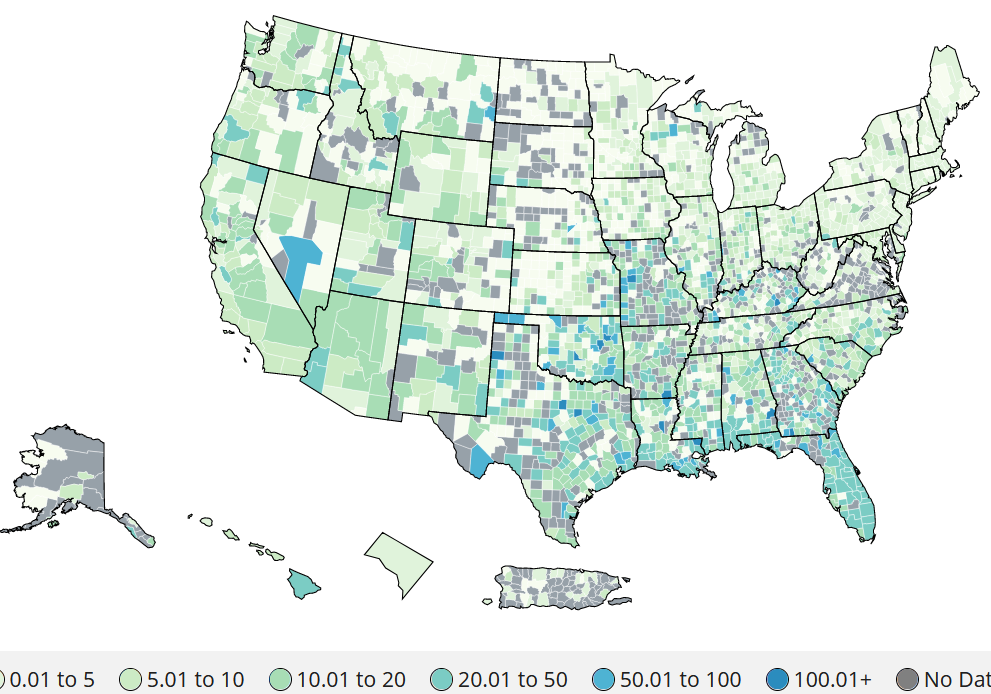 Occasionally one reads that climate change may benefit countries like Russia by delivering a longer growing season. However, this article from Geographical (UK) about the Russian Republic of Kalmykia, makes clear the issue is far more complex than that, especially as drought spreads on the steppe. geographical.co.uk/places/deserts/item/4101-the-republic-of-kalmykia-sits-at-the-forefront-of-global-climate-change-as-the-desert-encroaches
Urban areas around the world have distinct microbial communities. Scientists just analyzed more than 4,700 samples collected from the mass transit systems of 60 cities around the world and found that cities' microbial communities are quite distinct, influenced by climate, population density, soils, proximity to the equator, altitude, proximity to the coast, and local human microbiota. The resulting microbial atlas includes 10,928 viruses, 1,302 bacteria, and 2 archaea not previously found in reference sets and "highlights potential public health and forensic applications, and provides a culture-independent view of AMR [antimicrobial resistance] burden in cities." www.cell.com/cell/fulltext/S0092-8674(21)00585-7
Want to check the COVID vaccination rates for your county or for a location to which you might be traveling? This interactive map shows various metrics measuring COVID cases, deaths, and vaccinations by county in the U.S. www.tmj4.com/news/coronavirus/coronavirus-map
Supply-chain issues continue to plague the global economy. Nowhere have these issues been felt more keenly than in countries dependent on trade to feed themselves. Singapore, for example, imports more than 90% of its food. With just about 275 square miles of land area, less than 1% of which is devoted to agriculture, Singapore depends on daily shipments of fresh fruits and vegetables from Malaysia, Thailand, China, Indonesia, and elsewhere. During 2020, COVID restrictions accelerated Singapore's stake in vertical farming as a means of promoting food self-sufficiency. This article from BigThink is a good background piece on the current science, economics, and outlook for vertical farming: bigthink.com/technology-innovation/vertical-farming
Earlier this month, 18 prominent scientists published an open letter in the journal Science calling for a more thorough, transparent investigation of the origins of COVID-19. (China was notably uncooperative in the earlier WHO-commissioned inquiry, having taken down previously publicly available databases and pushing its preferred theory that COVID-19 originated outside of China. The director-general of the WHO has himself since called for a more thorough investigation.) Why does it matter where the virus originated? In the words of technology advisor Jamie Metzl, "When a plane crashes, you could say, 'Well, a plane crashed. We should redouble our efforts to make sure that we have safe skies.' You'd be right. But when a plane crashes, we also want to know why did this particular plane crash? Because that could point to a much bigger problem. You could say, 'there are lots of things that could lead to pandemics. One of them is unsafe laboratories and another is climate change and eco system destruction. We should do all of them.' But to prioritize our response, we need to recognize where the biggest challenges are. If ... COVID-19 comes from an accidental lab leak from the Wuhan Institute of Virology, that's a pretty big problem because that's not the only institute of virology in all of China or in all of the world. We need to prioritize that response now and in the future. If it's something else, that would be our starting point. I think it would be enormously self-defeating to say 'it doesn't matter where the worst pandemic in a century comes from and we should just play nice with everybody and move on and try to do a little bit of everything.'" (Quote from the March 17 "Intelligence Matters" podcast, which is not given to providing a platform to conspiracy theorists, on the considerable circumstantial evidence that China continues to hide what it knows about the origins of COVID-19. www.cbsnews.com/news/covid-19-origins-transparency-china/) The Wall Street Journal also published a good background piece on the recent push to investigate the origins of the virus: www.wsj.com/articles/wuhan-lab-leak-question-chinese-mine-covid-pandemic-11621871125
|
Blog sharing news about geography, philosophy, world affairs, and outside-the-box learning
Archives
December 2023
Categories
All
|
 RSS Feed