|
The National Oceanic and Atmospheric Administration (NOAA) developed the Science on a Sphere projection software for interactive 3D museum displays in 2004. Now, NOAA has released a free app to bring the same information, drawn from 140+ datasets and including real-time information, to bring geographic animations to the small screen. Users can track storms, monitor ocean temperature, check cropland, watch air traffic, map earthquakes, and much, much more. SOS Explorer or SOSx is available for iOS and Android. sos.noaa.gov/sos-explorer/about-sos-explorer/
0 Comments
For those accustomed to looking at some variant of the standard Mercator projection map (with the equator in the middle, the Americas to the left and Europe, Africa, Asia, and Australia to the right), this "vertical world map" from China will look radically different, with an emphasis on the Arctic and Asia. bigthink.com/strange-maps/future-world-map
"More than 80 percent of the world’s oceans are currently unmapped, but a $7 million prize pool to explore the deep sea hopes to change that. The Ocean Discovery XPrize was [recently] awarded to teams using uncrewed deep-sea vehicles to map the ocean floor and trace chemical signals underwater. The goal is to develop a comprehensive atlas by 2030. ... A comprehensive map of the world’s oceans may uncover new species and materials, and find old shipwrecks, says Jyotika Virmani, XPrize’s Ocean Discovery director. 'The deep sea is the world’s largest museum, and we don’t have access to it right now,' she says. Exploring is made notoriously difficult by extreme conditions such as darkness, high pressure, and cold.
"A $1 million bonus prize was also up for grabs for entrants to develop a vessel that could detect a chemical signal – a marine-safe coloured dye – and autonomously track it back to its source. The winning team was Ocean Quest, made up of high school students from San Jose, USA, although their vessel couldn’t sniff out signal back to the source within the allowed timeframe. Virmani says the technology could be used to track fish populations or invasive species. It could also be used in search and rescue missions, such as after planes crash into the ocean." www.newscientist.com/article/2205047-uncrewed-deep-sea-robots-will-help-map-the-worlds-oceans/ "Researchers at a Washington-based think tank have noticed that a funny thing happens whenever Russian President Vladimir Putin gets close to a harbor: The GPS of the ships moored there go haywire, placing them many miles away on the runways of nearby airports. According to a new report by security experts with the group C4ADS, the phenomenon suggests that Putin travels with a mobile GPS spoofing device and, more broadly, that Russia is manipulating global navigation systems on a scale far greater than previously understood." foreignpolicy.com/2019/04/03/russia-is-tricking-gps-to-protect-putin
There are 59 national parks in the U.S. (and one more each in American Samoa and the U.S. Virgin Islands). This map, which is essentially a Voronoi diagram, partitions the U.S. based on proximity to one of these national parks. The location of the parks themselves is shown with a small "+."
i.kinja-img.com/gawker-media/image/upload/s--7jxKwpk3--/c_scale,f_auto,fl_progressive,q_80,w_800/g4ol2crd7r0xsoxs1uo3.jpg Looking for a free, easy-to-use tool to make your own online maps? Try mapchart.net/world.html
Despite being developed in the mid-1500s and having significant, known distortions, the Mercator projection continues to be used on popular maps, its familiar grid made easy for navigation. This map compares the landmasses from a Mercator map (in light blue) with their actual relative size (in darker blue).
www.reddit.com/r/dataisbeautiful/comments/9nkg7k/map_projections_can_be_deceptive_oc/ Students in my "Mission Possible: Global Issues, Leadership Choices" class occasionally have to contend with Grey Swans, or unexpected events, that threaten to upend their plans. This article from Bloomberg Businessweek looks at a real-life Grey Swan: the consequences of an accidental or intentional disruption of the Global Positioning System.
"GPS isn’t just for maps. It’s also a kind of vast, spaceborne clock. Computers all over Earth use it to determine what time it is, down to billionths of a second. When there’s the slightest disagreement among those computers, things fall apart. Microsemi’s timing receivers were frantically issuing error messages because of just such a discrepancy. ... Over the next 11 hours, cellphone towers lost their connections, U.S. police and fire stations reported communications errors, BBC radio signals were interrupted, and the telescope that tracks asteroids in Earth’s orbit went offline. ... It’s tough to overstate how GPS-dependent the world economy has become since the U.S. Department of Defense started giving the service away to the public in 2000. There are 2 billion GPS receivers in use around the world, a number that Europe’s satellite navigation agency estimates will hit 7 billion by 2022. Along with the telecommunications industry, banks, airlines, electric utilities, cloud computing businesses, and TV broadcasters require constantly precise GPS timing. Emergency services do, too, as do military forces. The U.S. Department of Homeland Security has designated 16 sectors of infrastructure as 'critical,' and 14 of them depend on GPS." www.bloomberg.com/news/features/2018-07-25/the-world-economy-runs-on-gps-it-needs-a-backup-plan Modern slavery takes many forms. In Southeast Asia, for example, the fishing fleet of Thailand, most prominently, relies heavily on men who are drugged, captured, tricked, or sold to work as forced labor. One of the factors that makes this possible is that these ships never dock: they transfer their cargo and take on supplies at sea. Governments have been turning a blind eye, but anti-slavery NGOs are now using the same tactic employed by groups trying to stop illegal fishing: tracking the GPS transponders of fishing vessels to identify those that never dock. www.economist.com/science-and-technology/2018/05/03/software-that-detects-human-trafficking
In a sign of the times, Google Maps may be adding a new feature: a circular red tag identifying locations with a confirmed active shooter. Google did this during the shooting at the (Google-owned) YouTube headquarters earlier this week, and Google Maps is reportedly in discussions with local law enforcement to add this feature. www.cnet.com/news/youtube-san-bruno-shooting-appears-on-google-maps/
This article written by a cartographer (professional map maker) compares Google Maps with Apple Maps and notes that Google Maps now incorporates so much data, much of it collected via satellite -- building data, for example, now includes detail of garages, tool sheds, bay windows, front steps, rooftop fan units... -- that "Google has gathered so much data, in so many areas, that it’s now crunching it together and creating features that Apple can’t make—surrounding Google Maps with a moat of time," insulating it from competition for the foreseeable future. www.justinobeirne.com/google-maps-moat
NASA recently updated its famous "world at night" images for the first time since 2012 and is employing new software to work towards providing real-time updates. This article explains some of the applications for real-time updates (like identifying areas of Puerto Rico without power after Hurricane Maria) and compares 2012 and 2016 images. www.nasa.gov/feature/goddard/2017/new-night-lights-maps-open-up-possible-real-time-applications 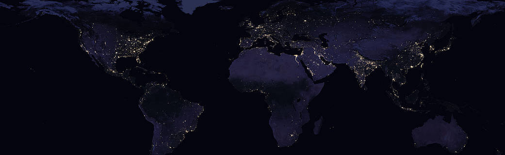 In advance of today's home school geography bee, I have spent some time this week playing with free geography apps. The two I like best? Geography Quiz by Peaksel (Android/iOS) and Geo Bee Now by Vishaal Ganesh (Android). The Peaksel app has, in addition to quiz questions, a photo and a brief explanation to support each answer. (The downside: there's an ad every few questions.) The Geo Bee Now app offers three levels of play, and the questions reflect a broad range of geographic subjects, similar to the National Geographic Society's geography bee. If you have a favorite geography app, please add it in the comments.
Google recently upgraded its cameras for the first time in eight years to provide Street View with more granular detail. (Street View photos capture more than just building fronts: analyzing the cars in the images also allows Google to draw inferences about income, race, and political preferences, among other things.) This site shows where Google's Street View has mapped and where it's heading next. www.google.com/streetview/understand/ 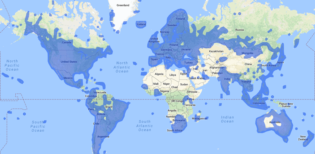 After a natural disaster, a detailed knowledge of geography can save lives. First responders and relief workers need to know what was there before a disaster hit -- especially number and types of buildings -- in order to know how many people might be in trouble where. Using satellite imagery and open access software, anyone with a computer can help. You can get started with the Humanitarian OpenStreetMap Team: www.hotosm.org/get-involved
I have written about Ventusky before, but it's worth repeating because the site is such a useful tool to see the characteristics of a hurricane in real time. This particular view shows wind speeds: www.ventusky.com/?p=23.9;-68.4;3&l=wind 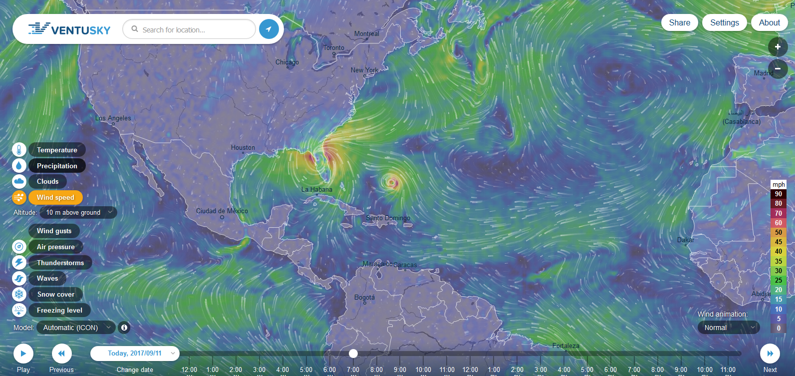 |
Blog sharing news about geography, philosophy, world affairs, and outside-the-box learning
Archives
December 2023
Categories
All
|
 RSS Feed