|
This 25-question quiz focuses on language geography: given a map, can you name the language spoken in the highlighted region? (Alumni of my "Your Future World: Human Geography 2050" class should be able to get perhaps not all but most of these.) www.sporcle.com/games/the_underground/maps_too_small_for_klingon
0 Comments
This interactive series of maps from Pew Research Center looks at the ethno-demographics of the American electorate, by state and over time: www.pewresearch.org/2020/09/23/the-changing-racial-and-ethnic-composition-of-the-u-s-electorate/
October 14 is National Fossil Day. You can use this interactive map from data mapping engineer Ian Webster to see what the earth looked like 20 million to 750 million years ago and what kinds of dinosaur fossils can be found near your town (or any other). dinosaurpictures.org/ancient-earth#260
Is it art? Is it science? It's both! You can see the winning videos and honorable mentions from this year's Nikon Small World micro video photography contest here:
www.nikonsmallworld.com/galleries/2020-small-world-in-motion-competition (Archives of previous years' winners also available at the Small World website.) Celebrate fall: here is this year's interactive map from SmokyMountains.com of 2020 peak foliage predictions across the U.S.: smokymountains.com/fall-foliage-map/
It's another devastating wildfire season for California. My kids had a permit to hike Mount Whitney, the tallest mountain in the contiguous U.S., for tomorrow morning, but the National Forest Service closed 8 California national forests, including Inyo National Forest surrounding Mount Whitney, and pulled all hiking permits indefinitely Monday night for the first time in decades ;-(. This interactive map from the California Department of Forestry and Fire Protection tracks wildfires across the state, including the ones in the southern Sierra Nevadas near Mount Whitney. www.fire.ca.gov/incidents/ 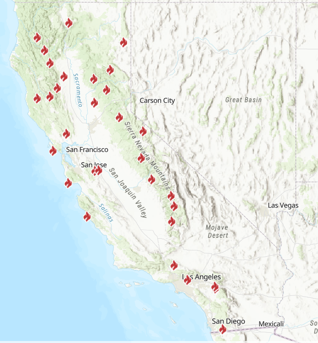 Create art, experiment with geometry, and learn a bit of cultural geography while using this very online cool mosaic tile simulator from the Qatar Foundation International. (Here is a tile pattern I made :-) tilemaker.teachalmasdar.com/tile?68157) tilemaker.teachalmasdar.com/  The U.S. National Oceanic and Atmospheric Administration is not just tracking but also using sophisticated models to forecast the impact of smoke from wildfires in California and elsewhere. The HRRR-Smoke site allows users to see actual fires (based on satellite data), near-surface smoke (which impacts breathing), and vertically-integrated smoke (showing the spread of smoke in the atmosphere). hwp-viz.gsd.esrl.noaa.gov/smoke/index.html# (This image shows the near-surface smoke forecast for this afternoon.) 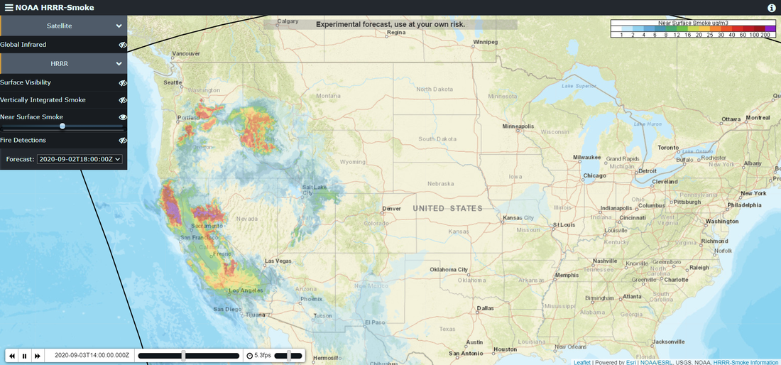 What do you know about ocean geography? Take this 24-question quiz to find out: www.usefultrivia.com/geography_trivia/ocean_trivia.html (For any students interested in the National Geographic Society geography bee, please note that although I, personally, consider the answer to #2 correct, NGS considers the world to have four oceans.)
Looking for a book on logic and critical thinking? Philosopher Alan Lavin is making his book Thinking Well available for free online. You can check it out or download it from the link on his website: www.alav.in/thinking-well/
Learn something about Kenyan wildlife and help out with a citizen science project at the same time! Researchers are trying to track the transmission of parasites on the savanna and need help identifying the wildlife and behaviors captured on camera at various watering holes. (I admit, I find this somewhat addictive.) www.zooniverse.org/projects/gtitcomb/parasite-safari
Most of this summer's Shakespeare in the park performances have been canceled. But you can watch one of my favorite performances online for free. This is the Folger Theatre's 2008 staging of Macbeth, with special-effects assistance from Teller (of the award-winning magic duo Penn & Teller). www.folger.edu/video-macbeth-folger-theatre
Geographical (UK) provides its top picks for board games for budding geographers. Geographical's favorite game -- Conservation Crisis -- does not seem to have been released in board game form in the U.S. yet, but it is available as an app (Android or iOS) for $1.99. geographical.co.uk/people/item/3683-curbing-boredom-geographical-s-top-board-games-for-geographers
The University of Arizona has created an imaginative (free) web quest to encourage students to learn about the world. Students can take any of five digital journeys to learn about places, languages, cultures, and histories, with a special emphasis on the Middle East and Latin America. las.arizona.edu/road-maps-around-world-adventure
School in the UK has gone online too, and the BBC is offering new bite-size lessons, across the curriculum and for all grade levels (ages 5-15), every day. Pick an age/grade and see what's available: www.bbc.co.uk/bitesize/dailylessons
This geo-graphic shows the reproduction rate (R) of COVID-19 transmissions by state. The first graph shows each state's R number and allows users to compare R values between states across the last several weeks. An R value above 1 means the virus is likely to spread; an R value below 1 means the virus will stop spreading. The subsequent graphs show the progression of each state's R value since early March. rt.live/
The 50th anniversary of the original Earth Day was earlier this week. While the U.S. has made strides in controlling some pollutants, others, like the toxic fluorinated compounds known collectively as PFAS, remain a problem and persist in the environment for a very long time. This interactive map shows known PFAS contamination sites in the U.S. www.ewg.org/interactive-maps/2019_pfas_contamination/map/
You can take a virtual tour, led by a U.S. park ranger, in five of America's national parks: Kenai Fjords (Alaska), Carlsbad Caverns (New Mexico), Hawaii Volcanoes (Hawaii), Dry Tortguas (Florida), or Bryce Canyon (Utah). artsandculture.withgoogle.com/en-us/national-parks-service/parks
Practice your U.S. geography: with or without using a U.S. map, try this quiz that pairs two U.S. cities and asks you to identify which one is further north. Be sure to read the interesting factoids that accompany each answer. play.howstuffworks.com/quiz/can-you-guess-which-of-these-two-american-cities-is-furthest-north
Having spent most of the last two weeks confined to a house I had no particular wish to leave, I have been reminded of John Locke's free-will analogy. Locke, a 17th century English philosopher, wrote, "Suppose a man be carried, whilst fast asleep, into a room where is a person he longs to see and speak with; and be there locked fast in, beyond his power to get out: he awakes, and is glad to find himself in so desirable company, which he stays willingly in, i.e. prefers his stay to going away. I ask, is not this stay voluntary? I think nobody will doubt it: and yet, being locked fast in, it is evident he is not at liberty not to stay, he has not freedom to be gone." (from An Essay Concerning Human Understanding, 1690) For Locke, the man's freedom was an illusion; he could not have left even if he wanted to because the door (unbeknownst to him) was locked. Likewise, Locke believed that free will is an illusion, that our actions flow from prior causes and that even if we think we have the power to choose differently, we in fact do not. This 40-second video explains Locke's locked-room thought experiment. www.youtube.com/watch?v=xZMJ-xaaNu0
Genetic sequencing has found that there are now at least 8 different strains of COVID-19, with very small variations between them, circulating around the world. This site maps out the dominant strains by country and tries to recreate possible routes of transmission and evolution. nextstrain.org/ncov?d=map,entropy&p=full
This map from a major health care provider shows the availability of intensive care unit (ICU) beds in the United States, by county. The counties in orange have no ICU beds. The counties in gray have no hospitals (!). The counties that fall into these categories are disproportionately rural and older. The article also addresses the huge variability in the number of ICU beds per resident in those counties that do have some ICU capacity (shown in blue) and has a searchable data table that allows users to compare ICU beds, population, and population age 60+ by county. khn.org/news/as-coronavirus-spreads-widely-millions-of-older-americans-live-in-counties-with-no-icu-beds/
The National Geographic Society just canceled this year's state and national geography bees for the first time in the bee's 32-year-history 😕. If you want to get a head start on learning about geography for next year, check out some of these free apps: Geo Bee Now for Android and iOS, Geography Quiz (by Peaksel) for Android and iOS, and the Ultimate Geography Quiz for Android.
The maps in this article tell the story of COVID-19. The interactive map at the end of the article, based on data collected by Johns Hopkins, is the best I have found for those interested in more-or-less real-time information. storymaps.arcgis.com/stories/4fdc0d03d3a34aa485de1fb0d2650ee0
Stuck in the house? Explore.org is the world's largest wildlife cam network. Watch who comes and goes at a South African watering hole, bald eagles on their nests, the residents of a kelp forest, gorillas in the DRC, Florida manatees, and more. explore.org/livecams/
|
Blog sharing news about geography, philosophy, world affairs, and outside-the-box learning
Archives
December 2023
Categories
All
|
 RSS Feed