|
This article in Geographical (UK) by geography journalist Tim Marshall provides a good overview of the history of Western Sahara and possible consequences of last December's decision by the U.S. government to recognize Morocco's claims to Western Sahara. geographical.co.uk/geopolitics/hotspot/item/3978-geopolitical-hotspot-western-sahara
0 Comments
Because warmer air can hold more moisture, humidity is expected to rise along with global temperatures. A recent study published in Nature Geoscience suggests that the combination could push human life in the tropics to the breaking point. "Humans’ ability to regulate their body heat is dependent upon the temperature and humidity of the surrounding air. We have a core body temperature that stays relatively stable at 37C (98.6F), while our skin is cooler to allow heat to flow away from the inner body. But should the wet-bulb temperature – a measure of air temperature and humidity – pass 35C, high skin temperature means the body is unable to cool itself, with potentially deadly consequences. ... The research team looked at various historical data and simulations to determine how wet-bulb temperature extremes will change as the planet continues to heat up, discovering that these extremes in the tropics increase at around the same rate as the tropical mean temperature. ... This has potentially dire implications for a huge swathe of humanity. Around 40% of the world’s population currently lives in tropical countries, with this proportion set to expand to half of the global population by 2050 due to the large proportion of young people in region. The Princeton research was centered on latitudes found between 20 degrees north, a line that cuts through Mexico, Libya and India, to 20 degrees south, which goes through Brazil, Madagascar and the northern reaches of Australia. ... '“Theoretically no human can tolerate a wet bulb temperature of above 35C, no matter how much water they have to drink,' [Boise State climate risk expert Mojtaba Sadegh] added."
www.theguardian.com/science/2021/mar/08/global-heating-tropical-regions-human-livability Trade, including the transit of oil from the Arabian Peninsula to Europe, via the Suez Canal has resumed. This map shows important potential chokepoints, including the Suez Canal, in the global oil trade: cdn.statcdn.com/Infographic/images/normal/18109.jpeg
Although the kidnapping of schoolchildren by Boko Haram makes the news in the U.S., kidnapping schoolchildren has become regrettably common across Nigeria, including in regions far from where Boko Haram operates the northeast, as this map, from The Wall Street Journal, makes clear. "Since December, heavily armed criminal gangs have abducted and ransomed more than 800 schoolchildren, rocking Nigeria.... Hundreds of school campuses have been closed across four states for fear of more attacks, leaving close to 15 million Nigerian children out of school—more than any other country in the world. ... Nigeria’s wave of violent crime is widening an arc of instability that has spread into three of its neighboring countries: Niger, Cameroon and Chad." www.wsj.com/articles/kidnapping-schoolchildren-in-nigeria-becomes-big-business-11616511947
Shutting off the internet has become an increasingly popular option for asserting governmental control. This geo-graphic looks at the countries in which people began searching for internet workarounds over the last year and indicates what was going on at the time: www.statista.com/chart/24122/vpn-search-during-internet-shutdowns
This geo-graphic looks at extreme poverty around the world (measured as living on $1.90 per day or less). If one can believe the numbers, it is worth noting that China's extreme poverty rate is now the same as that of the U.S., Japan, Canada, and Norway, among others. The size of the circle in each band reflects the number of people in extreme poverty. howmuch.net/articles/extreme-poverty-around-world
What appears to be an accidental explosion at a military facility in Equatorial Guinea this week has claimed the lives of roughly 100 people and injured hundreds more. The explosion occurred in the mainland city of Bata, on the Atlantic coast. More than half of Equatorial Guinea's population lives in either Bata or the capital of Malabo, which, as this map shows, is not on the mainland (known as Rio Muni) but is instead on the nearby island of Bioko. Equatorial Guinea is actually not equatorial -- the Equator runs just south of the country -- but it is the only African country in which Spanish is the official language. www.worldatlas.com/r/w1200/upload/6e/ee/19/gq-01.jpg
Swedish carmaker Volvo announced this week that it will cease manufacturing cars with internal combustion engines in less than a decade, by 2030. This map shows current plans by various national and subnational governments to phase out sales of internal combustion cars. sailthru-media.s3.amazonaws.com/composer/images/sailthru-prod-53o/Global-ICE-phaseout-map-nov2020.png
Earlier this week, the U.S. Department of Commerce finalized its study of unfair trading practices on flat-rolled sheet aluminum imported from 18 countries (shown in aluminum-gray on this map :-)). New tariffs range from to 2.7% on Greek flat-rolled sheet aluminum to 243% on German sheet aluminum. (These come on top of the 10% aluminum tariffs imposed by the Trump administration, citing national security.) www.reuters.com/article/us-usa-trade-aluminum/u-s-commerce-sets-anti-dumping-duties-on-aluminum-sheet-from-18-countries-idUSKCN2AU2S4?il=0  Until the U.S. passed the grim milestone of 500,000 COVID deaths recently, over the last month most COVID news in the U.S. has focused on aspects of vaccine rollouts. But as of earlier this week, the countries shown in red on this map have not yet been able to start COVID vaccinations: www.statista.com/chart/24242/status-of-global-vaccination-campaigns
According to Foreign Policy, Irish citizens are getting around their country's coronavirus restrictions by booking dentist appointments...in the Canary Islands. Ireland's travel restrictions provide an exemption for "essential medical, health or dental services" with proof of the appointment from a medical provider. Dental offices in Spain's Canary Islands, a sunny archipelago off the coast of Morocco, report a surge in appointments from Irish patients requesting email confirmations of their appointments. The Irish "patients" are, apparently, generally no-shows, creating bottlenecks for Canary Islanders with actual dental problems. canariesinfo.co.uk/images/spaingif.GIF
The region of northwestern Somalia known as Somaliland (shown in yellow on this map) has been seeking independence from Somalia for more than 30 years. Unlike the rest of Somalia, Somaliland is largely peaceful, with a functioning government and no significant threat from Al-Shabaab terrorism. Somaliland has its own currency, military, and flag. But what it doesn't have is international recognition. Now Somaliland hopes to use its ancient rock paintings, some of the world's oldest, as a bargaining chip with the international community: without recognition of its independence, Somaliland is dependent on Somalia for all aid, including cultural aid, which leaves Somaliland's archaeological treasures, like the rock paintings at Laas Geel, vulnerable to neglect and attack. If the world wants to save these early records of human art, the theory goes, the world needs to pave the way for tourism and outside funding by recognizing Somaliland's independence. www.washingtonpost.com/world/2021/02/01/somaliland-independence-laas-geel-rock-paintings
The UN recently announced that outbreaks of ovine rinderpest, a highly contagious sheep and goat virus with a fatality rate of 30-70%, have fallen by two-thirds in the last few years following an aggressive animal vaccination campaign. According to the UN's Food and Agriculture Organization, some 300 million families worldwide rely on sheep and/or goats for food and income. This Reddit map highlights the nine countries in which there are actually more sheep than people: preview.redd.it/kbcnvrb260d61.jpg?width=960&crop=smart&auto=webp&s=aa0e81d39c1284f17aba8bbfb617683bd94345c8
This geo-graphic from The Economist (UK) features an assessment by Oxford Economics ranking countries' vulnerability to long-term COVID-related economic damage:
www.economist.com/graphic-detail/2020/12/15/which-economies-are-most-vulnerable-to-covid-19s-long-term-effects According to a new report by the International Chamber of Commerce’s International Maritime Bureau, kidnappings by pirates in the Gulf of Guinea hit a new record in 2020, with 130 crew members kidnapped in 22 separate incidents in 2020. With "with well-armed and violent gangs defying regional navies and marauding further out to sea," pirates in the Gulf of Guinea accounted for 95% of at-sea kidnappings globally in 2020. Although the Gulf of Guinea borders more than half a dozen countries and covers nearly 900,000 square miles, most of the pirates are believed to operate out of the Niger Delta region of southern Nigeria (major city: Port Harcourt). Quote from www.reuters.com/article/us-nigeria-security-pirates/gulf-of-guinea-pirate-kidnappings-hit-record-in-2020-idUSKBN29I1RV 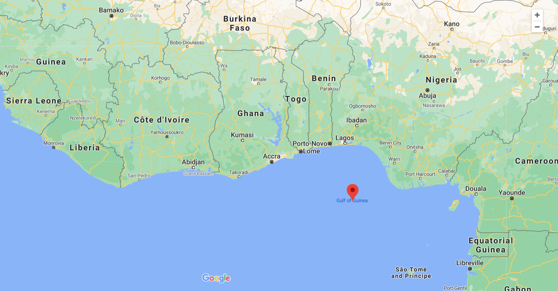 At least 100 villagers in southeastern Niger were killed earlier this week, most likely by a local Islamic State affiliate. Niger's Tillabéri Region (shown in red on this Voice of America map) borders Mali (to the north), Burkina Faso (to the west), and Benin (to the south). Over the last few years, jihadist violence has spilled over the border from Mali into both Burkina Faso and Niger. im-media.voltron.voanews.com/Drupal/01live-166/2019-04/C3B88A7B-EE15-4D42-80CF-676873F0E560.png
To coax Morocco into normalizing relations with Israel, the U.S. agreed to recognize Morocco's claim to the disputed region of Western Sahara this week. (Previously, the U.S. had not taken a stand on the issue, in keeping with the UN position that the people of Western Sahara, previously Spanish Sahara, should be allowed to vote on governance of the territory.) Although Western Sahara's land is not of particular interest, being mostly desert without significant mineral resources, the waters off Western Sahara may contain oil and gas deposits and, due to the upwelling of the Canary Current, are one of the world's most productive fisheries, to which Morocco has been selling fishing rights. www.worldatlas.com/upload/b7/4b/b0/western-sahara-map.jpg
This article from Foreign Policy looks at the military, economic, environmental, and humanitarian implications of China's vast fishing fleet trawling international -- and other countries' -- waters:
"The Chinese fishing fleet only ventured further afield in 1985, when 13 trawlers were sent to plough northwest Africa’s fish-rich coastal waters. Today, according to a report by the British Overseas Development Institute, China’s blue-water fishing fleet is by far the world’s largest, and includes 12,490 unique vessels that were observed to have been fishing outside China’s internationally recognized EEZ in 2017 and 2018. That’s many times more than previous estimates, and very different from China’s own claim of having only 3,000 ships fishing international or other countries’ waters—but that’s only because China doesn’t recognize the United Nations Law of the Sea Treaty’s demarcation of maritime borders. Though China isn’t alone in its destructive fishing practices, it stands apart by virtue of its sheer size and the extent to which it pushes its highly subsidized fleet across the world’s oceans. It’s also the only country whose fishing fleet has a geopolitical mission, taking over weaker countries’ waters and expanding Beijing’s maritime territorial ambitions. One of the malicious consequences of all this is that China’s monster fishing fleet robs poorer nations—from North Korea to the countries of West Africa—of desperately needed protein. "... But the real force driving this and other human-rights disasters is China’s hunger for seafood. China’s 1.4 billion people not only consume 38 percent of global fish production, but indulge in one of the highest per-capita consumption rates of fish and seafood, both wild and farmed, in the world—37.8 kilograms per person per year, up from only 7 kilograms per person per year in 1985, according to figures provided by China to the U.N. Food and Agriculture Organization. While much has been written about Chinese overfishing, it’s only recently become possible to document its vast extent, thanks to new satellite technologies such as those providing data to Global Fishing Watch. The same tracking technology that is used to prevent vessels from hiding or circumventing sanctions shows that China’s fishing fleet appears engaged, often illegally, in the effort to haul in as much seafood as it can, as fast as it can, in as many places as it can—with little regard for how its practices affect malnourished people or diminish the stocks of their fish. This effort is not simply the sum of individual decisions made by skippers. It is government policy, because most vessels are in effect paid to fish by the Chinese government, which covers the fleet’s main operating expense: fuel. ... Besides its gigantic size and extreme level of subsidies, there is a third characteristic that sets the Chinese fishing fleet apart: its use by Beijing as a tool of expansion. ... China is the only country with a strategic fishing fleet. Of the crew on the vessels operating in the South China Sea, [China analyst at the Center for Strategic and International Studies Greg] Poling said 'either they’re fishers paid to go fish somewhere, and that’s the only reason they do it, or they are officially in the militia, which means they never fish—they just use fishing boats to monitor other fleets, run supplies, or ram other boats.'" foreignpolicy.com/2020/11/30/china-beijing-fishing-africa-north-korea-south-china-sea A recent report from the British nonprofit Save the Children finds that approximately one out of every six children on earth is living in a conflict zone, and "165 million of these children are affected by high intensity conflicts." This map shows the areas with the largest numbers of children living in conflict zones, including Honduras, with a total population of fewer than 10 million. For the complete report, see www.savethechildren.org.uk/content/dam/global/reports/education-and-child-protection/war_on_children-web.pdf
Ethiopia's northernmost regional state of Tigray (shown in orange on this Al Jazeera map) has been in the news recently: after the Tigray People's Liberation Front (TPLF) reportedly launched an attack on the Ethiopian military's northern command earlier this month, Ethiopia responded by declaring war on Tigray. Although ethnic Tigrayans account for about 6% of Ethiopia's population, TPLF ran Ethiopia, either directly or as the dominant partner in a coalition, for nearly 30 years until current prime minister Abiy Ahmed came to power in 2018. As a semi-autonomous state, Tigray itself has a military of roughly 250,000, suggesting any conflict could be prolonged and draw in neighboring states, including Eritrea (which is majority Tigrayan), Sudan, Somalia, and Djibouti. www.aljazeera.com/wp-content/uploads/2020/11/Etiopia-map-01.jpg (Map from www.aljazeera.com/news/2020/11/10/ethiopias-tigray-conflict-explained-in-500-words)
Elections and wars are inflection points rich in counterfactuals. The series of maps in this BBC Future article considers alternate histories, which have become a field of serious historical scholarship: what if the U.S. had lost the American Revolution? what if WWII hadn't been fought? what if the states of the United States had splintered in line with some actual proposals? www.bbc.com/future/article/20201104-the-intriguing-maps-that-reveal-alternate-histories
Gold prices have risen 25% since the beginning of the year. This map shows the world's major gold-producing regions, by tonnes mined. www.statista.com/chart/23053/gold-mines-by-tonnes-produced-annually
This map, from Storygardenz, attempts to place some of the Western world's most famous stories in their geographical context (from www.storygardenz.com/about).
The Indian Ocean island nation of Mauritius, considered part of Africa, usually derives much of its income from tourism, with its pristine beaches and coral reefs being the big draw. For the last six months, though, tourism has plummeted, and now Mauritius faces what may be a more long-lived threat to its tourism: heavy bunker fuel spilling out of a Japanese tanker that ran aground on a reef off Mauritius's east coast and is beginning to break apart. This map shows the tanker's route heading to Brazil from Singapore through the Strait of Malacca and across the Indian Ocean straight into a coral reef: specials-images.forbesimg.com/imageserve/5f32255b76f5a4d456105eb2/960x0.jpg Mauritius has declared a state of emergency, and residents are trying to stop the oil with homemade booms of hair, straw, tights, plastic bottles, and sugar cane leaves. (The map is from a great Forbes article on how satellite technology is being deployed in this situation: www.forbes.com/sites/nishandegnarain/2020/08/09/how-satellites-traced-the-fateful-journey-of-the-ship-that-led-to--mauritius-worst-oil-spill-disaster/#7db02e345b42.)
Did physical geography, including terrain and biogeography, influence early human brain development? New research suggests that yes, it did:
"'The basic idea is that open spaces—open grassland, flat plains—are just speed games, favoring the predator, since they are larger," [Northwestern University neuroscientist and engineer Malcolm] MacIver told Ars. 'Closed spaces—dense forests or jungles—favor simple strategies of running for cover. Using a complexity measure, we show both of these habitats have low complexity.' ... The complexity 'sweet spot,' according to MacIver, is a landscape like the one featured in The Hobbit chase scene, or like Botswana'a Okavango Delta, both of which feature an open grassland and moss zones dotted with clumps of trees and similar foliage. 'In this zone, neither speed games nor running for cover maximizes survival rate,' said MacIver. 'But planning—by which I mean imagining future paths and picking the best based on what you think your adversary will do—gives you a considerable advantage.' And that planning requires the kind of advanced neural circuitry typical of the human brain. MacIver and his Northwestern colleague and co-author, Ugurcan Mugan, performed numerous supercomputer simulations, which revealed that while seeing farther (MacIver's original theory) is needed for advance planning to emerge evolutionarily, it is not sufficient by itself. Rather, it requires a combination of long-range vision and complex landscapes. This, in turn, may have led to the development of one of the most difficult cognitive operations: envisioning the future. ... [I]n the simple water and land simulations, the prey showed low survival rates regardless of which strategy it employed, demonstrating that there was no evolutionary benefit to being able to plan in environments that are very open or too densely packed. In the former, the best bet is to try and outrun the predator; in the latter, there are too few clearly available paths, and the densely packed environment hinders how far the prey can see. But a patchy landscape in the Goldilocks zone of complexity showed a huge increase in survival rates for prey that relied on the planning strategy, compared to the habit-based approach." arstechnica.com/science/2020/07/how-the-geometry-of-ancient-habitats-may-have-influenced-human-brain-evolution |
Blog sharing news about geography, philosophy, world affairs, and outside-the-box learning
Archives
December 2023
Categories
All
|
 RSS Feed