|
Foreign correspondent and geography author Tim Marshall has a new book out The Power of Geography: Ten Maps That Reveal the Future of Our World. Marshall argues that rivers, mountains, deserts, and sea lanes shape a nation’s behavior as much as the ideological and cultural factors that get more attention. In The Power of Geography, Marshall looks at 10 countries/regions -- Australia, Iran, Saudi Arabia, the UK, Greece, Turkey, the Sahel, Ethiopia, Spain and outer space -- "chosen for their potential as geopolitical hotspots. These are places where we can expect things to happen, and soon. The big issues are all relevant here; these are places grappling with climate change, religion and struggles over resources, and are, above all, figuring out their place in the new world order." The Power of Geography is a sequel to Marshall's 2015 bestseller, Prisoners of Geography, which is also worth reading. (Quote from https://geographical.co.uk/reviews/books/item/4056-the-power-of-geography-ten-maps-that-reveal-the-future-of-our-world-by-tim-marshall-book-review.)
0 Comments
According to a recent report from First Street, nearly a quarter of U.S. critical infrastructure -- airports, police stations, utilities, hospitals, etc. -- are at risk of being inundated by floods, either from rivers or the seas. This article from Bloomberg provides a short summary of key findings and links to the entire 160+ page report: www.bloomberg.com/graphics/2021-flood-risk-critical-infrastructure/
Groundwater supplies half of the world's drinking water and 40% of the water used for irrigation. The Western U.S.'s besieged Ogallala Aquifer, for example, is the source of drinking water for more than 80% of the people who live in the High Plains yet this water is thousands of years old and will take thousands of years to recharge. This article looks at the use and science of aquifers and the geography of aquifer recharge across the U.S. theconversation.com/ancient-groundwater-why-the-water-youre-drinking-may-be-thousands-of-years-old-167982
Atmospheric rivers -- narrow bands of moisture-laden air -- are ranked like hurricanes according to intensity. This week northern California experienced a Category 5 atmospheric river, bringing mudslides, power outages, and extreme flooding to the region. On the plus side, the rain brought billions of gallons of water to depleted reservoirs. This map shows water levels in key California reservoirs (blue shows % of capacity; the red line shows historical average): www.sfchronicle.com/climate/article/Charts-show-where-California-reservoir-totals-16566209.php
The world's tropical glaciers are melting away as air temperatures heat up. This article from Atlas Obscura introduces what was once the world's highest ski resort, with an elevation higher than Mount Everest's base camp. Chacaltaya Ski Resort, near La Paz, Bolivia, was closed in 2009 when the Andean glacier upon which it depended melted. www.atlasobscura.com/places/abandoned-chacaltaya-ski-resort
Released earlier this month, this animation illustrating comparative ocean depths is worth checking out: www.youtube.com/watch?v=Q5C7sqVe2Vg Carbon dioxide accounts for roughly half of the increase in global temperatures observed over the last 250 years. But methane -- a byproduct of agriculture, oil/gas production, and waste management practices -- accounts for nearly a quarter of the rise in global temperatures. This map from Bloomberg shows how the primary contributors of methane vary by country and region. (For more on this issue, including more maps and a look at the chemistry of CO2 vs. methane see the original article: www.bloomberg.com/graphics/2021-methane-impact-on-climate/)
Did you know that there are waterfalls underwater?? The largest waterfall in the world is the Denmark Cataract, 2000 feet under the ocean in the Denmark Strait that separates Iceland and Greenland. Cold, dense water flows over the top of an undersea ridge and rapidly sinks two miles to the ocean floor, creating a "downward flow estimated at well over 123 million cubic feet per second," making this the world's largest and highest waterfall by a long shot. (For comparison, Angel Falls is 0.6 miles tall, and average flow over Victoria Falls is 33 thousand cubic feet per second.) oceanservice.noaa.gov/facts/largest-waterfall.html
Fall in the Northern Hemisphere means seasonal Arctic sea ice is reforming, creating pathways across what, in the summer, would be open water. This map shows the path of a single Arctic fox that walked from Norway (Svalbard) across Greenland to Canada (Ellesmere Island) in 2018. www.researchgate.net/figure/Large-scale-movements-of-a-young-female-Arctic-fox-from-Svalbard-tracked-through-Argos_fig1_334026698
Earlier this week, two freight trains operated by the Russian aluminum giant Rusal collided in the west African country of Guinea. The trains were carrying bauxite, the ore that is the primary source of aluminum. Guinea has the world's largest bauxite reserves; a recent coup in Guinea had already sent aluminum prices to their highest level in a decade. This map shows the world's largest known bauxite deposits: www.researchgate.net/profile/Weidong-Sun-5/publication/251702332/figure/fig3/AS:267643634581526@1440822623455/Distribution-of-the-superlarge-bauxite-deposits-in-the-world-After-Bogatyrev-etal.png
Six U.S. states are now categorized entirely as experiencing drought -- California (most of which is under "extreme" or "exceptional" drought, the two most severe categories), Idaho, Montana, Nevada, Oregon, and Utah -- with 94% of the West experiencing drought conditions. This article from San Jose, CA's Mercury News includes not just the weekly drought map produced by the University of Nebraska-Lincoln but also maps that show streamflow and expected precipitation (spoiler alert: not much for the West) as well as discussing the impact on crops, hydropower, drinking water, fishing, bathing, and grazing land. www.mercurynews.com/2021/09/16/the-wests-historic-drought-in-3-maps-3/
I have shared this site before, but I think it's worth doing again. Ventusky feeds real-time data into its system to create interactive weather maps showing temperature, precipitation, wind speed, snow cover, and more. In the fall, because the Atlantic hurricane season continues through the end of November, Ventusky allows users to watch potential storm systems develop off West Africa and move across the Atlantic. www.ventusky.com/
Scientists from the University of Copenhagen accidentally discovered the world's northernmost island -- and added 20,000 square feet to Denmark's territory in the process -- when they went, by helicopter, to collect biological samples from a remote island off the northeastern coast of Greenland named Oodaaq (shown in green on this map), previously believed to be the world's northernmost island, and instead put down on an as-yet-unnamed mound of silt and gravel 780 m. further north. Islands of sediment shaped by the currents, like the newly discovered island, are often transitory, coming and going with major storm action. 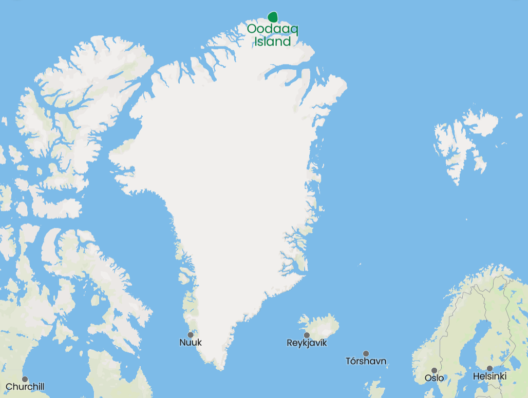 A new study, from a team of human geographers, analyzed satellite imagery of 913 major flooding events around the world from 2000 to 2018 and then compared population estimates in these same locations and discovered the population in flood-prone areas has grown by up to 86 million people, 10x faster than previously thought. Much of the population growth in floodplains has been part of the rural-to-urban migration in the Global South. www.washingtonpost.com/climate-environment/2021/08/04/tens-millions-people-have-been-moving-into-flood-zones-satellite-imagery-shows/
Based on declining water levels in Lake Mead, the U.S. declared the first ever "Tier 1" water shortage on the Colorado River last week, a measure that will force cuts in water apportionment along the river, especially in Arizona. This article from Bloomberg CityLab considers the impact on Phoenix and Arizona in general.
"The state of Arizona has been in drought since 1994. In that time, its population has almost doubled to 7.2 million people as of 2020, according to the U.S. Census Bureau. The majority of that growth has been in Maricopa, Pima, and Pinal counties, which cover the area around and between Arizona’s two largest cities Phoenix and Tucson. Both cities — along with native tribes, farmers, and municipal and industrial users — draw a substantial portion of their water from the Central Arizona Project, a system of canals and aqueducts that carries water from the Colorado River, more than 300 miles to the northwest. ... With the announcement [of the Tier 1 shortage] came cuts to CAP’s water supply. Early next year, supply will drop 30%. ... Arizona is one of seven states in the Colorado River Compact, a water-sharing agreement that goes back nearly 100 years. Given the drought conditions, in 2007 the members adopted interim guidelines to clarify how they would share the shrinking amount of water. By 2019, those guidelines were no longer adequate, and the states adopted the Drought Contingency Plan, which established a series of triggers for water reductions based on levels in Lake Mead. Members of the Colorado River Compact are granted different levels priority access to water in the event of a shortage much the way loan- and bondholders get priority access to capital in the event of a bankruptcy. Not only is Arizona among the first group to see reductions, it will also see far greater reductions than other areas, at least initially. ... There’s a hierarchy of users within CAP, as well. Farmers—who represent just 1% of the state’s economy but use 74% of its water—will bear the brunt of the first cuts." www.bloomberg.com/news/features/2021-08-21/one-of-phoenix-s-main-water-sources-is-drying-up Haiti's M7.2 earthquake last weekend is believed to have been triggered by the same fault as the M7.0 earthquake that leveled parts of Port-au-Prince, Haiti's capital, in 2010. Most of the Caribbean is seismically active, as this map shows. The strongest earthquake to hit the Caribbean in modern times was the 1843 earthquake in Guadeloupe (part of the eastern arc of Caribbean islands known as the Lesser Antilles), which could be felt as far away as NYC and is thought to have had a magnitude as high as 8.5, which would have been more than 10x more powerful than Haiti's recent earthquake! cdn.mos.cms.futurecdn.net/vAbzhEgRFTmUyweedLUVw-1200-80.jpg
And therein lies the rub: just days after the UN Intergovernmental Panel on Climate Change releases its bleak report on global warming, the Biden White House asks the OPEC+ group to pump more oil to bring down gasoline prices, which are at or near a seven-year high. OPEC+ refers to the official members of the Organization of Petroleum Exporting Countries, shown in dark blue on this map, and other major petroleum producers who often coordinate with OPEC but are not members of OPEC, shown in light blue on this map. www.insightsonindia.com/wp-content/uploads/2020/03/Break_through.png
NASA is forecasting that the second half of an oscillation now underway in the moon's orbit -- a moon wobble, as reported in many media outlets -- will significantly increase sunny day flooding at high tide in U.S. coastal areas. San Francisco, for example, is likely to see a 5x increase in high-tide flooding by 2030. "But 'it’s the accumulated effect over time that will have an impact,' study lead author Phil Thompson, an assistant professor at the University of Hawaii, said in a statement. 'If it floods 10 or 15 times a month, a business can’t keep operating with its parking lot under water. People lose their jobs because they can’t get to work. Seeping cesspools become a public health issue.'" www.miamiherald.com/news/nation-world/national/article252736353.html
Occasionally one reads that climate change may benefit countries like Russia by delivering a longer growing season. However, this article from Geographical (UK) about the Russian Republic of Kalmykia, makes clear the issue is far more complex than that, especially as drought spreads on the steppe. geographical.co.uk/places/deserts/item/4101-the-republic-of-kalmykia-sits-at-the-forefront-of-global-climate-change-as-the-desert-encroaches
Because tectonic plates are constantly in (slow) motion, many geographic landforms are constantly changing as well -- lakes and trenches that get deeper, seas that get smaller, mountains that get taller, islands that emerge or break off.... This article from Geographical (UK) discusses how tectonic plate movement is expected to change the face of the planet over the next 200-250 million years and includes a short video based on the work of Dutch geologists about the (distant) future's Somalaya mountains: geographical.co.uk/places/mountains/item/4092-predicting-the-formation-of-a-new-mountain-range
Heavy rainfall has led to devastating flooding in Germany, Belgium, and the Netherlands this week, primarily along the Rhine and the Meuse (French name)/Maas (Dutch/Flemish name) rivers and their tributaries. This map shows the rivers' watersheds (in black) with national boundaries shown in red.
www.researchgate.net/profile/Albrecht-Weerts/publication/320402299/figure/fig2/AS:551857768878080@1508584553526/Map-of-the-Meuse-and-Rhine-basins-and-the-forecasting-locations-that-are-considered-in.png Most of the plastic that ends up in the world's oceans enters via rivers, primarily Asian rivers that run through densely populated urban areas. In fact, a recent study finds that Asian rivers contribute more than 80% of the plastic that finds its way to the sea, with the Pasig River being the single largest source of plastic pollution. The Pasig is the river that bisects Manila, the capital city of the Philippines. According to this geo-graphic, three of the world's five most plastic-polluted rivers are in the Philippines. www.statista.com/chart/25005/riverine-plastic-emissions-by-continent
The primary case study in this New York Times article is Kobe, Japan, but the issues apply equally well to any coastal area in an earthquake zone, which includes much of the Philippines, Indonesia, Turkey, Greece, Italy, New Zealand, Chile, Mexico, the South Pacific, the Caribbean, and the U.S. Pacific coast, among many others: how does one build -- and pay for -- new sea walls that will not fail during the next earthquake? www.nytimes.com/2021/06/22/climate/san-francisco-sea-wall-earthquake.html
Extreme drought in the American Southwest has gotten most of the headlines, but this map from The Washington Post shows the severity of the problem in the northern half of the U.S. as well, in a nearly unbroken band from Minnesota to Washington and Oregon. (Map from www.washingtonpost.com/climate-environment/2021/07/01/underpaid-firefighters-overstretched-budgets-us-isnt-prepared-fires-fueled-by-climate-change/.)
Long ago, Native American communities were moved to or allowed to exist in marginal lands, lands that Euro-American settlers, miners, or the U.S. government didn't particularly want. Those marginal lands are now proving to be particularly vulnerable to climate change. This article looks at the intersection of physical geography and human geography via the current impacts of climate-related changes on Native communities -- from rising waters and melting permafrost in Alaska to extended drought in the Southwest and the Ozarks to coastal erosion in the Pacific Northwest -- and the tricky question of who is supposed to "fix" the problem. www.nytimes.com/2021/06/27/climate/climate-Native-Americans.html
|
Blog sharing news about geography, philosophy, world affairs, and outside-the-box learning
Archives
December 2023
Categories
All
|
 RSS Feed