|
India has more linguistic diversity than all of Europe put together: recent research shows at least 780 languages are spoken across India. This article highlights the work being done to document these languages and the political dimension of doing so while India's Hindu-nationalist BJP government is trying to make Hindi the country's national language. www.nytimes.com/2022/06/11/world/asia/india-languages-ganesh-devy.html
0 Comments
World Refugee Day was earlier this week. Although Ukrainian refugees -- now numbering 5.2 million -- have dominated the news this year, this map from Statista is a reminder that Ukrainians are just a fraction of the world's refugees: www.statista.com/chart/18436/total-number-of-refugees-by-origin-country
This article from Geographical (UK) profiles the world's 10 fastest-growing cities -- chances are you've heard of relatively few of them -- and looks at new additions to the list of the world's megacities (population 10M+): geographical.co.uk/culture/the-fastest-growing-cities?
Russian President Vladimir Putin recently compared himself to Czar Peter the Great, who waged war against neighbors to "reclaim" Russian lands. This map from Statista compares the borders of Russia today with the borders of the Russian empire at the beginning of WWI: cdn.statcdn.com/Infographic/images/normal/27605.jpeg
Although Russia has been the focus of the world's liberal democracies for the last several months, countering China remains the long-term project. In the wake of a recent security agreement between China and the Solomon Islands, The Economist (UK) looked at other countries in Asia, Africa, and Oceania in which China either already has a military base or likely has an interest in establishing a military base: www.economist.com/img/b/640/356/90/sites/default/files/images/print-edition/20220507_CNM979.png (Map from www.economist.com/china/2022/05/05/china-wants-to-increase-its-military-presence-abroad.)
The past two months were the hottest March and April in India in 122 Years, with high temperatures in the Delhi area occasionally exceeding 110°F. At the same time, shortages of coal for the country's power plants have resulted in daily power outages for 2 in 3 Indian households. Power plants in the Indian states of Rajasthan (capital: Jaipur), Maharashtra (capital: Mumbai), West Bengal (capital: Kolkata), and Tamil Nadu (capital: Chennai) have been experiencing the most critical shortages. www.businesstoday.in/latest/story/power-crisis-in-india-these-states-facing-electricity-problems-full-list-332105-2022-05-02
The war in Ukraine is bottling up wheat exports and, especially in the southern and eastern parts of the country, damaging winter wheat fields planted last fall and interfering with spring planting. This geo-graphic from Statista highlights the countries most dependent on Ukrainian and Russian wheat: www.statista.com/chart/27181/least-developed-countries-dependent-on-wheat-from-russia-ukraine
Shanghai is the world's busiest container port -- handling about 3x the container traffic of #2 Rotterdam -- and China's ongoing COVID lockdown of Shanghai is further gumming up global shipping. This map, based on live ship-tracking data, shows the backlog of ships earlier this week in the East China Sea, the mouth of the Yangtze River, and the Huangpu River waiting to be loaded and unloaded. cdn.statcdn.com/Infographic/images/normal/27343.jpeg
Data collected by the Pacific Group and analyzed by Statista finds that water-related conflicts have escalated sharply in the last decade, particularly in Asia and Africa, as this geo-graphic shows: www.statista.com/chart/27272/water-conflicts/ (The full data set is worth exploring to understand the growing range of ways in which water is being weaponized or spurring violence: www.worldwater.org/conflict/list/)
Changes in physical geography -- including changes in weather patterns -- can create biogeographic changes too. Australia's recent, and unprecedented, outbreak of Japanese encephalitis is a case in point. Japanese encephalitis is a mosquito-borne disease endemic to Asia. However, record flooding in eastern Australia in March created wetlands for migratory birds, which are thought to have brought Japanese encephalitis with them to Australia. When native mosquitoes, also plentiful due to the flooding, bit the infected birds and then people and other animals, both wild and domestic, Japanese encephalitis began spreading in Australia. Because the virus is now present in animal hosts, it is unlikely the disease will be eradicated from Australia. Instead, the geographic range for Japanese encephalitis has expanded to include eastern Australia. www.newscientist.com/article/2312539-australias-japanese-encephalitis-outbreak-blamed-on-climate-change/
As of late last month, an estimated 4 million people had left Ukraine, 9% of the population. This geo-graphic from Statista, based on data from the UN High Commissioner on Refugees, puts Ukraine in the context of previous refugee crises since 1960: www.statista.com/chart/27151/largest-refugee-crises-since-1960-by-peak-number-of-refugees
Not surprisingly, Russia has become the most sanctioned country in the world, with nearly 6,000 different sanctions targeting individuals and/or governmental entities. This geo-graphic from Statista looks at the countries with the most international sanctions. cdn.statcdn.com/Infographic/images/normal/27015.jpeg
China's agricultural minister recently announced China is looking at its worst winter wheat harvest since the founding of the People's Republic of China in 1949. Although the timing of the announcement is viewed as somewhat odd, China's wheat problems are assumed to be due to heavy rains and flooding in central China that impacted last fall's planting season. China is the world's largest producer and consumer of wheat. ipad.fas.usda.gov/rssiws/al/crop_production_maps/China/China_wheat.jpg
Egypt was once the bread basket of the ancient world. Today, it is the world's biggest importer of wheat. This map features the 10 biggest importers of wheat over the last 4 years -- with Egypt, Indonesia, and Turkey in the top three -- suggesting these countries are likely to feel the pinch of rising wheat prices and possible wheat shortages with Russian and Ukrainian wheat off the market. Egypt's heavy reliance on imported wheat coupled with its long political tradition of subsidizing bread makes it particularly vulnerable to crisis. 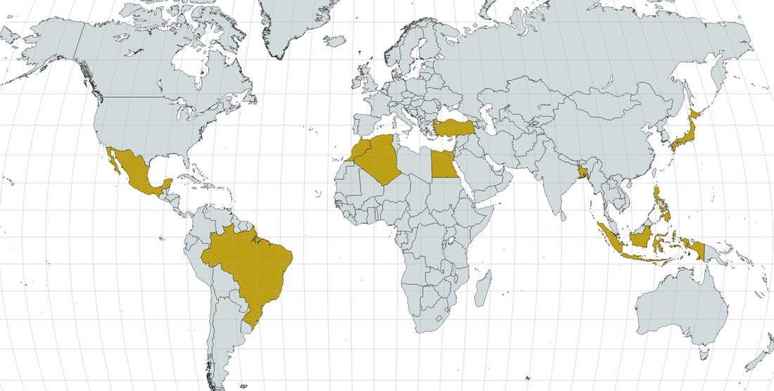 The Turkish government wants you to call the country "Türkiye" instead of "Turkey." Although Türkiye (formally, Türkiye Cumhuriyeti or Republic of Turkey) is what the country has called itself since 1923, maps in the English-speaking world have always used Turkey. This article explains the reasons behind the change and includes a YouTube clip featuring the correct pronunciation of "Türkiye," which may or may not catch on in the U.S.: www.afar.com/magazine/why-turkey-is-now-turkiye
Indonesia is officially moving its capital from Jakarta: earlier this week the Indonesian legislature authorized building a new capital, Nusantara, on the island of Borneo. This map from Statista looks at other national capitals that have moved (and why): cdn.statcdn.com/Infographic/images/normal/25119.jpeg
According to the Dutch VPN service Surfshark, more than 1/3 of the world's countries (71 total) have blocked or restricted internet access since 2015. This map shows, in orange, the countries that are currently blocking internet access (China, Iran, Turkmenistan, and North Korea) and, in red, those that have done so at some point since Jan. 2015: surfshark.com/wp-content/themes/surfshark/assets/img/social-media/social-media-access-min-upd1207.png For the full report, see surfshark.com/social-media-blocking
Researchers have "mapped the location and density of Earth’s irrecoverable carbon — carbon locked in ecosystems that is potentially vulnerable to release from human development and, if lost, could not be restored to those ecosystems by 2050." This irrecoverable carbon, mostly residing in forests, peatlands, mangroves, and other natural areas, has been described as "the carbon we must protect to avert climate catastrophe." www.sciencenews.org/wp-content/uploads/2021/11/111821_jl_carbon_inline_desktop_rev.png (Map and quotes from www.sciencenews.org/article/climate-change-natural-carbon-stores-new-map)
Although Barbados achieved independence in 1966, the island elected to remain a constitutional monarchy with Britain's Queen Elizabeth II as its titular head. Only recently, 55 years later, did Barbados choose to become an independent republic (while remaining part of the Commonwealth). This map from Statista shows countries that used to be part of the British Empire: www.statista.com/chart/26297/countries-gained-independence-from-the-uk/
Factories in China produce an estimated 80 billion (yes, billion) pairs of disposable chopsticks each year. More than half of these disposable chopsticks are made of bamboo, according to China's forestry service. This article from Atlas Obscura provides a look at the industry: www.atlasobscura.com/articles/photographing-bamboo-chopstick-production-china
When a U.S. submarine ran into an unmapped seamount in the South China Sea two months ago, many wondered how that could happen. It turns out only 19% of the world's sea floor has been mapped. Moreover, the South China Sea is known to have particularly tricky underwater terrain. You can use this mapping tool from the General Bathymetric Chart of the Oceans (GEBCO) to visualize ocean topography: download.gebco.net/ GEBCO is working to produce a complete, publicly available map of the world's oceans by 2030.
Stronger-than-usual trade winds are shifting water temperatures in the Pacific Ocean, creating a La Niña effect that is expected to influence weather patterns through the winter and into the spring. Because La Niña impacts vary with the location, check out the maps in this article to see what might be in store for you: www.wsj.com/articles/la-nina-is-coming-to-shape-winter-forecasts-what-to-know-11636666122
The northeastern Indian state of Assam (shown in red on this map) has been in the news recently. Although Assam is famous for its tea and silk, more recently Assam has been in the news for its efforts to evict Muslim residents whose families arrived from neighboring Bangladesh any time in the last 50 years. High birth rates and land erosion from the Brahmaputra River, which runs east to west the length of Assam, has increased competition for land and given Assam's Hindu-nationalist BJP government a pretext for taking action against Muslim settlers of Bangladeshi descent, most of whom were born in Assam. upload.wikimedia.org/wikipedia/commons/thumb/e/ec/India_Assam_locator_map.svg/1574px-India_Assam_locator_map.svg.png
In this article from Geographical (UK), geography writer Tim Marshall looks at the possible routes Afghans will take to leave the country: geographical.co.uk/geopolitics/hotspot/item/4151-geopolitical-hotspot-escaping-afghanistan
A few months ago, the Chinese Communist party celebrated the 100th anniversary of its founding. This GIF maps the global spread, and decline, of Communism for a slightly different 100-year interval, from 1917 to 2017: www.reddit.com/r/MapPorn/comments/pvx2s5/rise_and_fall_of_communism/
|
Blog sharing news about geography, philosophy, world affairs, and outside-the-box learning
Archives
December 2023
Categories
All
|
 RSS Feed