|
Israel is facing a particularly difficult leadership choice in the coming months and years: does it want to preserve its democracy or does it want to preserve its Jewish majority? New data in a report delivered to the Israeli Knesset recently suggest the numbers of Jews and Arabs in the land currently controlled by Israel (from the Jordan River to the Mediterranean) are now essentially equal. Although this demographic issue has been discussed, and dismissed, as a possibility for years, the Israeli army's Civil Administration unit reports that it is now a fact. www.al-monitor.com/pulse/originals/2018/04/israel-palestinians-demography-jordan-river-apartheid.html
0 Comments
Want to learn about the Middle East from the experts? Now you have the chance (if you're in the DC metro area). The Middle East Institute is running an 8-week class "Middle East 2030: Trends, Challenges & Opportunities" Thursday evenings beginning March 15. For all the information, see www.mei.edu/events/middle-east-2030-trends-challenges-and-opportunities 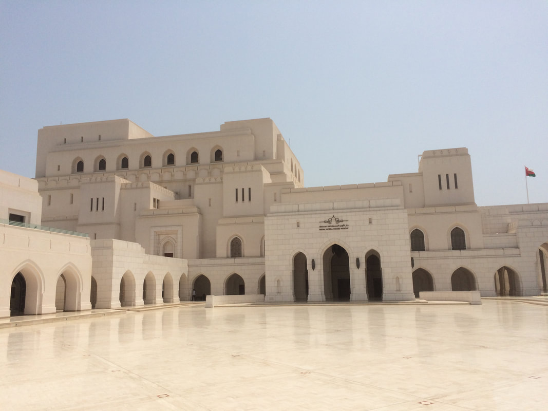 The uprising that led to the Syrian civil war will mark its 7th anniversary in two weeks. Fighting and civilian casualties have intensified recently in Afrin (between Turkish-backed forces and Kurdish militias in northwest Syria) and in Eastern Ghouta (between government-backed forces and rebels just east of the capital of Damascus). This map, updated regularly in Al Jazeera (Qatar), shows regions of control and active conflict zones.
www.aljazeera.com/mritems/Images/2018/2/26/acfd95ed0db746428d4178c37175bd67_6.jpg "The question that dominates my waking hours now is: When Day Zero arrives, how do we make water accessible and prevent anarchy?" says the mayor of Capetown, South Africa, in a recent National Geographic article on Capetown's water crisis. [As I noted in a different post a few weeks ago, Capetown is expected to have to turn off its public water supplies in two months (more or less, depending on the success of water conservation efforts) because the water level in the city's reservoir is approaching, functionally, zero. The army is on standby to maintain order.] This article from the BBC (UK) looks at 11 other major cities likely to run out of drinking water (Cairo? London? Bangalore? Sao Paulo? Beijing? Istanbul?): www.bbc.com/news/world-42982959
Continuing protests in Iran's oil-rich Khuzestan region are being fueled by choking smog. For several years, Iranian cities have ranked at or near the top of the World Health Organization's list of most polluted cities. The primary contributor? Sand and dust, generated by decades of land use decisions. This article from The Guardian (UK) is a good background piece on the political choices and consequences that have led to the current situation: www.theguardian.com/world/iran-blog/2015/apr/16/iran-khuzestan-environment-wetlands-dust-pollution
The U.S. has been supporting the Saudis' war against Yemen's Houthi movement for more than two years, contributing to the world's worst humanitarian crisis. But who are the Houthis? Why do the Saudis want to see them defeated? Why is the U.S. involved? This article by Brookings scholar (and former intelligence official) Bruce Riedel is an excellent primer for anyone seeking to understand the Houthis and the current conflict in Yemen: www.brookings.edu/blog/markaz/2017/12/18/who-are-the-houthis-and-why-are-we-at-war-with-them/
This map considers the dominant Y-DNA haplogroup (passed from father to son) across Europe, the Middle East, and North Africa. brilliantmaps.com/europe-dna-borders/ 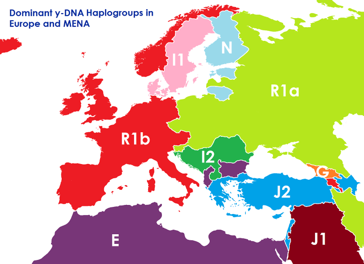 The Institute for Economics & Peace has released its 2017 Global Terrorism Index. The good news: deaths due to terrorism dropped 13% globally between 2015 and 2016, including declines in Afghanistan, Nigeria, Pakistan, and Syria (which together, along with Iraq, accounted for 3/4 of all terrorism-related deaths). The bad news: more countries than ever before (77) reported at least one death due to terrorism in 2016, terrorist attacks against civilians were up 17% on the year, and certain countries have seen significant increases in terrorism-related deaths (a single-year increase of 40% in Iraq, an 8-fold increase in Egypt since 2002, a 16-fold increase in Turkey since 2002). The chart below shows the 10 most fatal terrorist attacks in 2016. For the full report, see visionofhumanity.org/app/uploads/2017/11/Global-Terrorism-Index-2017.pdf
The Middle East Institute is offering a new online class "The Middle East in Transition: Stalled Uprisings, Failed States, and Regional Conflict." Incorporating video lectures, readings, and Q&A with MEI scholars, this eight-lesson class looks like an excellent resource for any teen or adult interested in current events, the Middle East, or modern world history. middle-east-institute.thinkific.com/courses/the-middle-east-in-transition
The constraints of physical geography have shaped how humans have solved problems of food, shelter, and energy. This image is not a giant beehive. It is a kind of refrigerator/freezer dating back to 400 BC. Developed by the Persians, yakhchals had thick clay walls and a shape that brought in cool air at floor level while venting warmer air out the top. (Interestingly, the same basic engineering principles are now being used to create solar updraft towers: using that warm venting air to turn a turbine.) www.atlasobscura.com/places/yakhchals
With more than 5,000 new cases of cholera diagnosed every day, the UN has declared Yemen to be suffering from "the world's worst cholera outbreak." In Yemen, cholera rates tend to be worse in places of higher population density but also proportionately worse in the Houthi-held areas of the country (northwest and west). This map looks at the distribution of cholera cases. www.aljazeera.com/indepth/interactive/2017/06/yemen-world-worst-cholera-outbreak-mapped-170627110239483.html
A months-long civil protest, focused primarily in the mountainous region of northern Morocco known as the Rif, has gone all but unnoticed in the U.S. Protesters in Rif are objecting to police brutality, but this is just the latest chapter in Rif's estrangement from the rest of Morocco. Not only is the region mountainous, it is historically Berber, not Arab, and was a Spanish, not French, colony prior to independence in 1956, putting it at a geographic, linguistic, ethnic, and economic disadvantage when the country was re-unified. Even though Rif has a relatively small population, it has produced most of the Moroccan immigrants to Western Europe. This map shows the former colony of Spanish Morocco and the independent city of Tangier with, outlined in red, the once-aspirational Republic of Rif. upload.wikimedia.org/wikipedia/commons/thumb/4/43/Rep%C3%BAblica_del_Rif.svg/2000px-Rep%C3%BAblica_del_Rif.svg.png 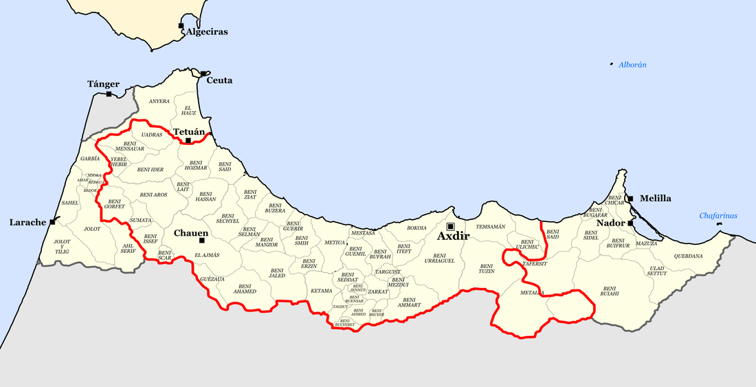 Turkey continues to host more Syrian refugees, by far, than any other country: nearly 3 million. (Lebanon is #2 with as many as 2 million, but because of Lebanon's small population, Syrian refugees account for roughly 1 in 4 people in Lebanon. The U.S., by way of comparison, hosts 18,000 Syrian refugees.) As this map from The Economist (UK) shows, Syrian refugees in Turkey have tended to either stay near the Syrian border or move to Turkey's major cities (which students in my "10 Weeks in Asia" class would recognize to be Istanbul, Ankara, and Izmir). cdn.static-economist.com/sites/default/files/images/print-edition/20170701_EUM958.png
One of the most visible aspects of human geography, defining our space and how we use it, is our architecture. This geo-graphic looks at the one of the most iconic examples of modern architecture: the skyscraper -- and the resulting competition to build the tallest, most elaborate skyscraper. howmuch.net/articles/most-expensive-skyscrapers-in-last-30-years
With a fragile cease fire in place in southwestern Syria, this map shows regions of control as they currently exist. [Damascus is the capital of Syria; Aleppo had been Syria's largest city before the civil war; Raqqa was claimed by the Islamic State as its capital; Deir Az Zor is where IS is regrouping now that Raqqa is encircled and Mosul is (mostly) back under the control of the Iraqi government.] interactive.aljazeera.com/aje/syriamap/syriamap.jpg
Given last week's decision by Saudi Arabia and some of its allies to cut off ties with the nearby island nation of Qatar, this map, showing the presence of U.S. military forces in the Middle East, becomes rather interesting. www.statista.com/chart/9727/where-us-troops-are-based-in-the-middle-east/
With the U.S. president visiting Saudi Arabia today it seemed a good time to share an excellent source of information about Middle Eastern geography: Gulf/2000, a project of the Middle East Institute at Columbia University. Gulf/2000 has dozens (hundreds?) of maps detailing the region's cultural, economic, historical, and political geography. For example, this map looks at Saudi Arabia's tribal geography. (If one looks carefully, one can find the Sa'ud family just west of Riyadh.) gulf2000.columbia.edu/images/maps/Saudi_Tribes_lg.png 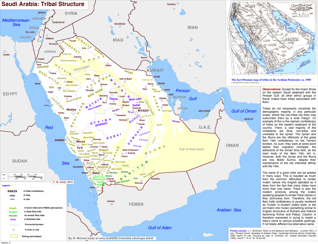 Having just sat on an airplane for a long time, I was thinking about the world's longest commercial airline routes. The longest flight, which premiered earlier this year, is from Doha (Qatar) to Auckland (New Zealand) and traverses more than 9000 miles in 16+ hours. This map shows its route. At present, seven of the world's 10 longest commercial flights involve travel to or from the Middle East, reflecting the region's growing influence as an air traffic hub. www.telegraph.co.uk/travel/news/longest-flight-in-the-world-qatar-doha-auckland/
Cities are one of the most distinctive ways in which peoples have put their marks on the landscape. The oldest city with "skyscrapers" is in central Yemen. Built of mud bricks, the high rises of Shibam are an interesting study in how geography shapes architectural form and function. www.nationalgeographic.com/travel/destinations/middle-east/yemen/shibam-mud-skyscraper-yemen/
Western Sahara and its Sahrawi people have been in the news lately. But what is Western Sahara anyway? Western Sahara is a region along the Atlantic Ocean claimed by Morocco and bordered by Morocco, Algeria, and Mauritania. It had been a Spanish colony (and may be shown as "Spanish Sahara" on older maps). However, when other European countries were under pressure to give up their colonies after WWII, Spain, governed by its long-time military dictator, Francisco Franco, did not. It was not until the month Franco died, in November 1975, that Spain finally agreed to relinquish its control of Western Sahara. Morocco and Mauritania immediately claimed portions of Western Sahara for themselves, over the objections of the native Sahrawi people. Morocco eventually won out, and tens of thousands of Sahrawi continue to live in refugee camps in Algeria, which has been a key sponsor of the Polisario Front, the Sahrawi resistance movement fighting for Western Sahara's independence. Western Sahara is the most populous territory on the United Nation's list of Non-Self-Governing Territories. c8.alamy.com/comp/GA4ER8/western-sahara-political-map-with-capital-laayoune-national-borders-GA4ER8.jpg
Yemen has been described as the forgotten Arab Spring country with the forgotten civil war. The Trump Administration has decided to increase U.S. support for the Saudi coalition seeking to defeat Yemen's Houthi forces. To better understand the issues and choices involves, this BBC article provides a good starting point, looking at the causes, players, and status of Yemen's civil war: http://www.bbc.com/news/world-middle-east-29319423
Students in one of my classes design their own city on the last day of class, and, invariably, they design a city with streets. But one of the earliest examples of a city -- Catalhöyük, in south-central Turkey -- was built without streets: people walked over the roofs of the buildings and entered the buildings via holes in the roof! Catalhöyük was declared a UNESCO World Heritage Site in 2012. www.catalhoyuk.com/site/architecture
Despite long involvement in the Middle East, Americans tend to have a weak understanding of the region's complex interplay of languages and ethnicities. This map shows the language geography of Iran. (The unlabeled white areas are Iran's major deserts.) Only slightly more than half of Iranians speak Persian, the official language, as their first language (if at all). qph.ec.quoracdn.net/main-qimg-50ea7de29c5fd7409ea441768b365d6d?convert_to_webp=true
This map, from the Institute for the Study of War and based on data current through last week, hints at the complexity of the military situation in Syria. News reports of a possible peace deal brokered by the U.S. and Russia tend to gloss over the difficulties of deciding who belongs at the negotiation table. For a more detailed image, see www.understandingwar.org/sites/default/files/September7%20EDITS%20COT.pdf
|
Blog sharing news about geography, philosophy, world affairs, and outside-the-box learning
Archives
December 2023
Categories
All
|
 RSS Feed