|
Greenland, which is administered by Denmark, has been in the news lately. Greenland is the world's biggest island. This map shows the world's 10 biggest islands: www.statista.com/chart/19047/total-area-of-the-worlds-largest-islands/ It should be noted, though, that because of the mapping projection used, the size of Greenland and the other Arctic islands is greatly magnified. (My "Hands-On Geography" students sometimes ask, "Why is Greenland an island and Australia isn't?" There is no excellent answer to this question. You will find things like this www.worldislandinfo.com/CONTISLAND.html online, but Australia was named a continent prior to a scientific understanding of tectonic plates and the flora and fauna are not truly unique in that there are striking similarities to species in Indonesia and the Philippines east of the Wallace Line. In other words, geographers lucked into some scientific support for their classification of Australia, and not Greenland, as a continent rather than an island.)
0 Comments
The Imperial Japanese Navy lost 334 ships during World War II. This map captures the final resting place of most of them. worldwarwings.com/wp-content/uploads/2018/06/ships-map.jpg
Much of the eastern and central U.S. has been struggling through an excessively wet spring, to the point that many farmers still have not been able to plant their crops. It is easy to forget that this experience is not the norm, though. This map looks at precipitation patterns globally over the last two years. The areas in dark red -- which include most of Australia and Western Europe, much of northern South America, parts of India, Canada, and the western U.S., and much of southern Africa, the Sahel, and the Horn of Africa -- have experienced significantly below-average precipitation through the two years ending in May. You can play with the parameters of the data to see where drought is evident or imminent: spei.csic.es/map/maps.html 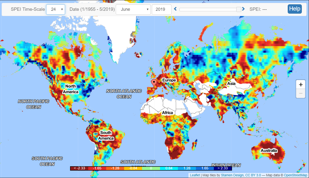 This map, from an Australian site affiliated with Quantas Airways, pairs regions of Australia with other areas of the world, based on climate. (To see the analogues for cooler, rainier Tasmania, click on the link.) awol.junkee.com/this-fascinating-map-shows-us-australias-climate-twins
A cartogram is map that has been weighted for a particular variable. In this case, the variable is either the population of domesticated sheep (in green) or cattle (in red). Not only do these maps and cartograms reveal important geographic differences in sheep and cattle production -- reflecting both cultural preferences and physical geography -- they also highlight areas that are amenable to neither, including the dead zone in central Africa due to the tsetse fly. geographical.co.uk/images/articles/places/mapping/2019/Cattle_and_sheep/Webcartogram.jpg
Which is the best country in the world for doing business? According to this ranking, it is New Zealand (again), followed by Singapore and Denmark. This map highlights the top 10 and the bottom 10 countries for doing business, but many other countries' rankings are also shown. www.visualcapitalist.com/worlds-best-and-worst-places-for-business/
The World Bank has announced that extreme poverty (defined as living on income of less than $1.90 per day) has fallen to a record low 10% of global population. These maps look at extreme poverty rates globally and by continent. howmuch.net/articles/people-living-in-extreme-poverty-2018
This interactive mapping site allows you to enter any location in North America, Australia, or New Zealand, as well as parts of South America and Greenland, to find out which indigenous people(s) used to live where you do now. native-land.ca/
Australians are preparing to head into their summer with drought conditions already evident in sections of the country, made worse by the driest July in more than 15 years. This map, from Australia's Bureau of Meteorology, shows the varying levels of rainfall deficiencies across the country. www.bom.gov.au/climate/drought/archive/20180802.drought1.lr.col.gif 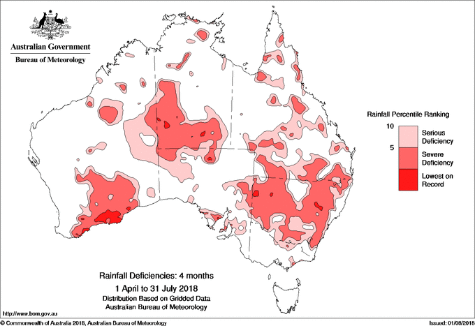 An earthquake last November has changed the coastline of New Zealand's South Island. The 7.8 earthquake uplifted the seafloor, creating a new wall of purplish stone two meters high near Kaikoura, on the northeast coast of the island. geographical.co.uk/nature/oceans/item/2041-new-zealand-s-new-coastline
We are about at the halfway point of Ramadan, the month during which observant Muslims fast from sunrise to sunset. But, as this map shows, the time between sunrise and sunset varies greatly depending on where one is, from 11.5 hours in Melbourne to nearly 19.5 hours in Oslo. (However, according to this article, most Muslim scholars agree that Muslims near the poles can choose to fast during the daylight hours for Mecca or for the nearest Muslim-majority country, which in the case of Norway would be Bosnia.) www.statista.com/chart/13924/ramadan-fasting-times/
Dotting the Pacific Ocean are dozens of islands, some independent, some joined in federation, and many administered by larger countries. This map illustrates the complex political geography of the Pacific and Oceania. upload.wikimedia.org/wikipedia/commons/8/8d/Oceania_Political_Map_%28EEZ_based%29.png 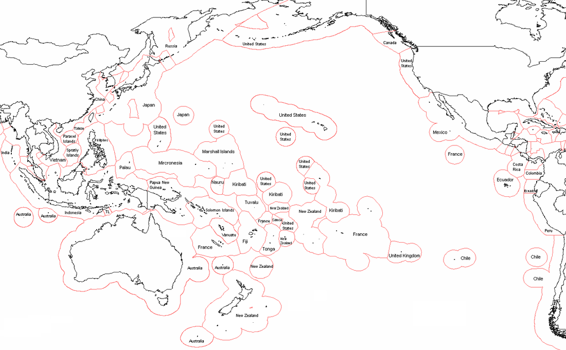 When Europeans arrived in Rapa Nui (also known as Easter Island) in on Easter Sunday 1722, they were astonished to find the island already had a native community numbering in the thousands. Famous for the giant stone heads (moai) rimming its coastline, Easter Island not only was the most remote populated island in the world, it was likely one of the last places settled by humans (about 900 years ago). Although culturally part of Polynesia, today Easter Island is administered by Chile. "The question that dominates my waking hours now is: When Day Zero arrives, how do we make water accessible and prevent anarchy?" says the mayor of Capetown, South Africa, in a recent National Geographic article on Capetown's water crisis. [As I noted in a different post a few weeks ago, Capetown is expected to have to turn off its public water supplies in two months (more or less, depending on the success of water conservation efforts) because the water level in the city's reservoir is approaching, functionally, zero. The army is on standby to maintain order.] This article from the BBC (UK) looks at 11 other major cities likely to run out of drinking water (Cairo? London? Bangalore? Sao Paulo? Beijing? Istanbul?): www.bbc.com/news/world-42982959
New Zealand may become the first country to issue special refugee visas for climate change refugees. (The current 1951 definition of a "refugee" requires that a person have a well-founded fear of persecution in his/her home country; "persecution" doesn't apply in the case of people fleeing climate change impacts.) New Zealand's legislature is considering the new visa class to assist populations of neighboring Pacific islands threatened by rising seas. geographical.co.uk/people/the-refugee-crisis/item/2539-changing-climate
New Zealand's two major islands (the North Island and the South Island) are separated by the Cook Strait. The North Island is home to 3/4 of the country's population, but this map shows even there the population is concentrated in a few specific locations: the population of the green areas rounds to zero people per square kilometer. www.nzherald.co.nz/resizer/FkDilYsUaUOtiuVXuxK5izigfe4=/620x884/smart/filters:quality(70)/arc-anglerfish-syd-prod-nzme.s3.amazonaws.com/public/GLFNE2UDIZHZXEJ4P5OGMO7CZI.JPG
This interesting map considers the world's most isolated cities with a population over 100,000, based on their distance to the nearest city that also has a population of more than 100,000. The top two are American cities: Honolulu at #1 and Anchorage at #2. cityextremes.com/isolated.php
Are politically independent floating city-states part of the geography of the future? Earlier this year, French Polynesia agreed to let construction begin on a floating city off its shores in international waters. "Long the stuff of science fiction, so-called 'seasteading' has in recent years matured from pure fantasy into something approaching reality, and there are now companies, academics, architects and even a government working together on a prototype by 2020." www.nytimes.com/2017/11/13/business/dealbook/seasteading-floating-cities.html
Tomorrow is the 80th anniversary of the disappearance of Amelia Earhart. Earhart and her navigator were attempting to fly around the world when their plane went missing. On July 2, 1937, they left Lae, eastern New Guinea (then a British possession governed by Australia), heading east towards Howland Island (a tiny uninhabited coral island administered by the U.S.), where they intended to refuel. They never arrived and are generally assumed to have missed the island -- it's only about 1.75 square miles -- and run out of fuel somewhere in the Pacific. See if you can find Howland Island! www.jarvisisland.info/maps/oceania.gif
Having just sat on an airplane for a long time, I was thinking about the world's longest commercial airline routes. The longest flight, which premiered earlier this year, is from Doha (Qatar) to Auckland (New Zealand) and traverses more than 9000 miles in 16+ hours. This map shows its route. At present, seven of the world's 10 longest commercial flights involve travel to or from the Middle East, reflecting the region's growing influence as an air traffic hub. www.telegraph.co.uk/travel/news/longest-flight-in-the-world-qatar-doha-auckland/
"Zealandia" has been making the news: is it a new continent or not? A team of geologists has claimed that the mostly submerged chunk of the earth's crust, bigger than the Indian subcontinent and including New Zealand and the French-governed island of New Caledonia to the north, meets all of the requirements for a continent. (At present, the National Geographic Society still considers it a micro-continent.) This article from Geographical (UK) does a nice job summarizing the issue: geographical.co.uk/nature/tectonics/item/2136-zealandia-what-is-a-continent
In keeping with the Valentine's color scheme, this article highlights one of my favorite geographic oddities: pink lakes. High mineral/salt content gives rise to species of algae and/or bacteria that create the pink appearance. traveleering.com/10-best-pink-lakes-world/
Due to tectonic plate activity, navigation maps for Australia need to be updated because the continent has moved about 5 feet since maps were last corrected in 1994 and because GPS-based navigation requires more precision than maps of a generation ago. news.nationalgeographic.com/2016/09/australia-moves-gps-coordinates-adjusted-continental-drift/
|
Blog sharing news about geography, philosophy, world affairs, and outside-the-box learning
Archives
December 2023
Categories
All
|
 RSS Feed