|
COVID-19 is having an unexpected impact on weather forecasting. "For years, thousands of airliners and cargo planes have been involved in a side gig that few passengers or package shippers have been privy to: gathering and transmitting weather data that’s then used for improving weather forecasts issued worldwide. To gather crucial information for operating the plane itself, such as determining its airspeed and motion relative to the ground, instruments on an airplane’s nose — they resemble pointy, metal needles sticking out of the fuselage, pointed forward, into the airstream — measure the characteristics of the air mass around them. ... Government programs run in the United States, such as the efforts of the National Oceanic and Atmospheric Administration, along with international agencies and private companies have tapped into some of this data to pipe it into computer models that help meteorologists forecast the weather. This includes the National Weather Service’s Global Forecast System, or GFS model, and the world-leading European model, run by the European Center for Medium Range Weather Forecasts (ECMWF) in Reading, England. At the global level, networks that vacuum up data from planes flying in Europe, Asia and South America have helped to ensure an ever-growing flow of data that’s benefited modeling centers worldwide, boosting model skill and forecast accuracy. However, with the paucity of flights in the air now, the pandemic has disrupted that data flow, turning it from a fire hose to more of a trickle." Globally, data collection is down 75-80%, but in the Southern Hemisphere, 90% of measurements provided by aircraft have gone missing. Meteorologist are unsure what impact the loss of data will have on weather modeling and forecasting, but the issue is "potentially problematic" given that this year's Atlantic hurricane season, which officially started yesterday, is expected to be busier than average. www.washingtonpost.com/weather/2020/05/12/weather-forecasting-coronavirus-flights/
0 Comments
After back-to-back hurricanes Irma and Maria sent as many as 250,000 evacuees into Florida's narrow interior in 2017, managers in Orlando and the surrounding area began thinking about how to prepare for future environmental migrants. "As a starting point, the cities need data, some sense of how many people might arrive. But one of the biggest hitches in planning for the future is that so little is known about where and when people will choose to migrate. ... Taking a holistic look at what drives migration is known as 'migration systems theory.' Using that approach, in a study reported in 2017 in Nature Climate Change, [Florida State University professor Matthew] Hauer identified 10 likely 'climate destination' regions in the United States for the estimated 13.1 million people within the country who are expected to be displaced by rising sea levels by 2100. Based on his simulations, the top destinations include Austin, Orlando and Atlanta. Hauer’s study was the first to attempt to anticipate destination regions for U.S. climate migrants. ... But more accurate simulations of widespread climate migration should consider one more dimension of the decision-making process, [Vivek Shandas of Portland State University] says: how people might decide when it’s time to leave. ... That decision will likely be different depending on the type of climate trigger, Shandas says. A growing field of research called event ecology uses computer models to anticipate how an extreme event, such as a hurricane, might ripple through a community, altering population numbers and infrastructure. Those kinds of events — sudden, short-term and extreme, such as Katrina in 2005 — are called 'pulse events.' Migrations spurred by pulse events are fairly easy to simulate. There’s one point of origin, and scientists can make knowledgeable guesses about where people might go from that point of origin based on proximity to other cities, family connections and job availability. Pulse event migrations also tend to occur shortly after the triggering event. But ongoing climate change can boost the frequency of pulse events. For example, climate change is increasing the risk of deadly and destructive wildfires, such as those that struck California in 2017, 2018 and 2019. Each event may trigger some migration, but over time those who stayed behind may also begin to wonder whether they, too, should move to a safer haven. Such slower, longer-term manifestations of climate change, or 'press events,' can be more challenging when it comes to anticipating both when and where people may choose to move. ... And it’s with these events that people’s different risk tolerances most come into play. ... Many people will face the dire choice between individual migration, community-based movement away from the risk, known as 'managed retreat,' or even deciding to find ways to stay in place. ... And there are many other lingering unknowns when it comes to assessing people’s decisions. 'We know very little about how different age groups would respond to different stimuli,' Hauer says." www.sciencenews.org/article/climate-change-migrants-destination-cities-data-orlando
If the world's cows were a country, they would be the world's 6th largest emitter of greenhouse gases, primarily because of their methane-rich burps. With more people starting to shun beef and dairy products in response, the livestock industry is looking to science for a solution. A Swiss company, for example, is testing a garlic-based product that reduces cow methane production by 30%. www.nytimes.com/2020/05/01/business/cow-methane-climate-change.html
Oil prices went negative briefly two weeks ago, but the U.S. is still producing near-record amounts of oil, more than 12 million barrels a day. About 30% of U.S. domestic oil (and 10% of domestic natural gas) production is coming from the Permian Basin of western Texas and southeastern New Mexico, shown in the light purple box on this map. However, an analysis of satellite data shows the petroleum industry operating in the Permian Basin is also generating the highest levels of methane (a greenhouse gas 80 times as potent at CO2) ever recorded in a U.S. oil- and gas-producing region. More than 2.5 teragrams of methane, representing nearly 4% of the region's natural gas production, leaked into the atmosphere in the year ending March 2019, more than double the amount detected the prior year. www.sciencenews.org/wp-content/uploads/2020/04/042220_cg_methane_inline1_680_desktop.png (Map from Science News:
www.sciencenews.org/article/permian-basin-oil-region-leaking-twice-methane-once-thought.) This article explains current research to understand Thwaites, the world's "riskiest" and "most important" glacier, according to some scientists. "A complex interplay of topography, climatic change and ocean currents have coalesced to make the western regions of Antarctica (where Thwaites is situated) particularly vulnerable. Topography is critical when it comes to the reasons why Thwaites is acutely exposed. Antarctica is often split into East and West – not simply to make the vast continent easier to represent but because there are fundamental differences between the regions. ‘East Antarctica is principally a large continent with mountain ranges and thick ice, but west Antarctica is more like an archipelago of islands – predominantly below sea level and vulnerable to change,’ explains [Andy] Smith [a senior glaciologist at the British Antarctic Survey]. The increased presence of warmer water, carried towards the southern polar regions by ocean conveyors, is exacerbating issues. Usually, the continental shelf keeps the warm water in the deep ocean surrounding the continent. In recent decades, however, more warm water has got over the continental shelf and flowed down towards the ice. If the warm water thins the ice, it also opens up a larger gap underneath the sheet, exposing more of the underlying ice and potentially precipitating an accelerated rate of retreat. Thwaites is of particular interest not only due to its scale and the underlying topography but also due to what it is supporting. ‘Thwaites has access to a massive inland reservoir of ice and so changes to Thwaites could affect the whole ice sheet,’ says Smith. ‘Other glaciers are still important, but they don’t have the same potential to have such a significant impact on sea level rise.’ Ice draining from Thwaites accounts for approximately four per cent of global sea-level rise and the collapse of the glacier could potentially cause global sea levels to rise by up to 80cm." geographical.co.uk/nature/polar/item/3606-investigating-thwaites-the-riskiest-glacier-on-earth
Australia has been in the news recently due to its intense heat and wildfires. This map, from Meteoblue which shows global high temperatures for today, helps illustrate why. 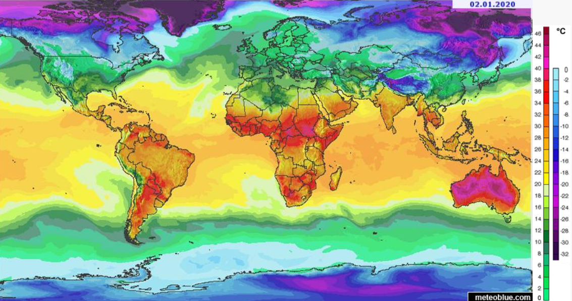 This map is based on 20 years of data collected by the National Oceanic and Atmospheric Administration and assesses the most common kind of weather-related death in the U.S. by region. Extreme heat has been far and away the biggest killer over this time period. https://i.imgur.com/sRbDui1.png (from https://www.considerable.com/life/death/weather-deaths-us)
An analysis of more than 37,000 media articles -- from 85 news sources, representing 45 countries on every inhabited continent and the full range of political ideologies -- reveals that the most predictive factor in media coverage of climate change is a country's per capita GDP. "In general, richer countries framed the issue as a domestic, political one, while poorer countries framed it as an international issue that the world at large needs to tackle." geographical.co.uk/nature/climate/item/3432-rich-and-poor-countries-cover-the-climate-crisis-very-differently
Assembling data from nearly 7000 sites around the world, researchers have assembled the first map of global earthworm distribution. "During the 1800s, intrepid explorers collected and cataloged many of the world’s plants and animals, providing range maps for different species that launched further study. But that wasn’t true for subterranean life. ... [E]arthworms have been studied long enough in Europe that most of the species are known. (The United Kingdom has 33 kinds.) But in the tropics, 'Every time they dig a hole, they find a new species of earthworm,' [soil ecologist Helen] Phillips says. ... [Researchers] were surprised when their analysis showed that temperature and rainfall seem to have a greater influence on where earthworms do best than soil type, they report today in Science. ... The effects of temperature and rainfall suggest climate change will have a far greater influence on below-ground life than expected, they say. Consequently, life above ground might also be affected in ways not previously anticipated. The distribution of different earthworm species was also surprising. When it comes to life above ground, the tropics have the greatest biodiversity. But underground, these constantly warm regions are far less diverse, at least at a local scale: The rich soils of Europe, the northeastern United States, the southern tip of South America, and the southern regions of New Zealand and Australia seem to have more earthworm species in a given area. Those temperate zones also host more earthworms overall, according to the model, with up to 150 per square meter versus just five per square meter in the tropics." www.sciencemag.org/news/2019/10/first-global-map-earthworms-reveals-which-places-are-chock-full-them-and-why
"According to a new U.S. Army report, Americans could face a horrifically grim future from climate change involving blackouts, disease, thirst, starvation and war. The study found that the US military itself might also collapse. This could all happen over the next two decades, the report notes. The senior US government officials who wrote the report are from several key agencies including the Army, Defense Intelligence Agency, and NASA. The study called on the Pentagon to urgently prepare for the possibility that domestic power, water, and food systems might collapse due to the impacts of climate change as we near mid-century. The two most prominent scenarios in the report focus on the risk of a collapse of the power grid within “the next 20 years,” and the danger of disease epidemics. Both could be triggered by climate change in the near-term, it notes.
“Increased energy requirements” triggered by new weather patterns like extended periods of heat, drought, and cold could eventually overwhelm “an already fragile system.” The report also warns that the US military should prepare for new foreign interventions in Syria-style conflicts, triggered due to climate-related impacts. Bangladesh in particular is highlighted as the most vulnerable country to climate collapse in the world. ... But without urgent reforms, the report warns that the US military itself could end up effectively collapsing as it tries to respond to climate collapse. It could lose capacity to contain threats in the US and could wilt into “mission failure” abroad due to inadequate water supplies." Excerpted from www.vice.com/en_us/article/mbmkz8/us-military-could-collapse-within-20-years-due-to-climate-change-report-commissioned-by-pentagon-says The report itself is available here: climateandsecurity.files.wordpress.com/2019/07/implications-of-climate-change-for-us-army_army-war-college_2019.pdf Although changes in rainfall patterns in sub-Saharan Africa may still be devastating to farmers, recent research suggests that aquifer levels may be at less risk than supposed. "[I]n much of sub-Saharan Africa, groundwater is a vital resource. It is often the only source of clean drinking water in rural areas and its use is also increasing in cities. ... A group of 32 researchers, led by UCL [University College London] and Cardiff University, sought to test this across nine countries in Africa, including Uganda, Tanzania and South Africa. The research involved analysing long-term records of groundwater levels and rainfall and, in a rare moment of good news, demonstrated that groundwater levels may be more resilient to climate change than previously thought, particularly in the driest areas. The key reason is that in dry areas most groundwater recharge takes place when water leaks out of temporary streams and ponds – a process which only happens after heavy rainfall. Climate change is expected to lead to fewer rainfall events in the region, but their intensity will increase. This in turn will increase leakage. As a result, the researchers predict that groundwater levels will remain resilient, even if the overall volume of rain decreases." geographical.co.uk/people/development/item/3383-ground-water
The decision by Pacific Gas & Electric to cut electricity in specific fire-prone parts of Northern California last week brought to mind this article from The Wall Street Journal, which is hardly an alarmist publication when it comes to climate change, earlier this year: "PG&E: The First Climate-Change Bankruptcy, Probably Not the Last"
"PG&E Corp.’s bankruptcy could mark a business milestone: the first major corporate casualty of climate change. Few people expect it will be the last. California’s largest utility was overwhelmed by rapid climatic changes as a prolonged drought dried out much of the state and decimated forests, dramatically increasing the risk of fire. On Monday, PG&E said it planned to file for Chapter 11 protection by month’s end, citing an estimated $30 billion in liabilities and 750 lawsuits from wildfires potentially caused by its power lines. The company’s fall has been fast and steep. In October, its market value was $25 billion. This week, it was removed from the S&P 500 as its value tumbled below $4 billion and its shares fell to their lowest level since at least 1972. "The PG&E bankruptcy could be a wake-up call for corporations, forcing them to expand how they think about climate-related risks, management consultants and other experts said. Previously, companies mainly worried over risks from new governmental regulations related to climate change, said Christophe Brognaux, a managing director at Boston Consulting Group. The PG&E case makes clear that companies also have to worry about sudden, and potentially unexpected, impacts to their core assets and liabilities, he added. 'Physical risks have only recently manifested themselves. This is a fairly new development,' said Bruce Usher, a professor at Columbia University’s business school who teaches a course on climate and finance. 'If you are not already considering extreme weather and other climatic events as one of many risk factors affecting business today, you are not doing your job.' "J. Bennett Johnston, a former Democratic U.S. senator from Louisiana who has served on Chevron Corp. ’s board of directors, said the potential for climate change to damage company assets and cause a mushrooming of liabilities is an emerging enterprise risk. 'The business community, by and large, has gotten the message,' he said. 'You have to be pretty stupid not to see we’re in the midst of a climate crisis and it’s getting worse.'" www.wsj.com/articles/pg-e-wildfires-and-the-first-climate-change-bankruptcy-11547820006 The recent fires in the Amazon rainforest, which is sometimes nicknamed the world's lungs because of its oversized role in global oxygen production, has given more attention to the idea that ecocide, like genocide, should be listed as a crime against humanity and prosecuted as such. This article from The New York Times looks at the history of the ecocide movement.
"There is no international crime today that can be used to neatly hold world leaders or corporate chief executives criminally responsible in peacetime for ecological catastrophes that result in the type of mass displacements and population wipeouts more commonly associated with war crimes. But environmentalists say the world should treat ecocide as a crime against humanity — like genocide — now that the imminent and long-term threats posed by a warming planet are coming into sharper focus. ... The first prominent call to outlaw ecocide was made in 1972 by Prime Minister Olof Palme of Sweden, who hosted the United Nations’ first major summit on the environment. In his keynote address at the conference, Mr. Palme argued that the world urgently needed a unified approach to safeguard the environment. “The air we breathe is not the property of any one nation, we share it,” he said. “The big oceans are not divided by national frontiers; they are our common property.” ... During the 1980s and 1990s, diplomats considered including ecocide as a grave crime as they debated the authorities of the International Criminal Court, which was primarily established to prosecute war crimes. But when the court’s founding document, known as the Rome Statute, went into force in 2002, language that would have criminalized large-scale environmental destruction had been stripped out at the insistence of major oil producing nations. ... "Facing a cascade of international pressure and a boycott of some Brazilian exports, [Brazilian president Jair] Bolsonaro last month ordered a military operation to put out fires in the Amazon. But the government’s overriding message has been that the world’s angst about the Amazon is an unwelcome and unwarranted intrusion on Brazil’s sovereignty. ... "In the best of cases, campaigners to outlaw ecocide say it would take a few years to muster the support they need to amend Rome Statute. But merely raising the profile of the debate over penalizing ecocide could go a long way toward shaping the risk assessment of corporations and world leaders who until now have regarded environmental disasters mainly as public relations nightmares." www.nytimes.com/2019/09/21/sunday-review/bolsonaro-amazon-fire.html This year has seen an unusually high number of cases of eastern equine encephalitis, a mosquito-borne virus that kills about one-third of the patients diagnosed with it. This map from Science News shows states that have had confirmed cases of eastern equine encephalitis over the last decade, with roughly 30% of these cases occurring just in the first nine months of 2019. Scientists are unsure if 2019 is an anomaly or suggestive of a spread of the virus and its vectors, but early springs and late frosts extended the mosquito breeding season and the period of possible disease transmission. www.sciencenews.org/wp-content/uploads/2019/10/092719_sb_triple-e_inline2-map_680_desktop_rev.png
Leaf peeper alert: this series of maps forecasts peak fall foliage across the U.S. www.citylab.com/life/2019/09/fall-colors-map-when-will-leaves-change-autumn-peak-foliage/598300/
The National Oceanic and Atmospheric Administration (NOAA) developed the Science on a Sphere projection software for interactive 3D museum displays in 2004. Now, NOAA has released a free app to bring the same information, drawn from 140+ datasets and including real-time information, to bring geographic animations to the small screen. Users can track storms, monitor ocean temperature, check cropland, watch air traffic, map earthquakes, and much, much more. SOS Explorer or SOSx is available for iOS and Android. sos.noaa.gov/sos-explorer/about-sos-explorer/
It is not clear that concerns about climate change have gotten to the point that governments are seriously considering geoengineering -- who would make the decision to use it? -- but the science has been advancing. This article provides a quick summary of one kind of potential geoengineering: seeding the upper atmosphere with sulfur.
"Changing our behaviour towards the environment is increasingly being seen as a necessity, but making large-scale alterations to our lifestyles is taking time. ... While a solid, long-term fix is being developed, potentially radical methods are increasingly being considered. Solar geoengineering (SG) requires using fleets of aircraft to inject tonnes of sulphur into the stratosphere – between six and 30 miles into the sky. Despite sounding unorthodox, it’s a technique that has been on the minds of climate scientists for a while. A team of researchers from Harvard University, Princeton University, and the Massachusetts Institute of Technology (MIT) has started to take the initiative and have published their findings in Nature Climate Change. ... The thinking is that by injecting sulphur into the atmosphere, it will form a reflective layer, dimming the sun’s rays and cooling the planet’s temperature. This belief isn’t entirely abstract. In 1991, following the eruption of Mount Pinatubo in the Philippines, 17 megatons of sulphur dioxide entered the stratosphere. This cooled the Earth’s average temperature by 0.5°C. ... Approximately two years after the Pinatubo eruption, the effects wore off. ... "Dimming the sun’s rays has been shown to impact plant life, plants that currently offset some 25 per cent of humanity’s CO2. It would also put food supplies under strain. Further, as solar geoengineering doesn’t negate CO2 emissions, the process of oceanic acidification continues. The oceans absorb one-third of our CO2, which raises its acidity levels. Over the last 200 years, the acidity of the oceans has increased by 26 per cent. This leads to the breakdown of calcium carbonate, which destroys corals and damages shell-based life. Also endangered by oceanic acidification are the water-based, microscopic organisms known as phytoplankton. Although tiny in size, these organisms account for half of the amount of oxygen we breathe. They also produce the chemical dimethylsulphide, a crucial part of the nuclei of water vapour, allowing it to form into raindrops. With less phytoplankton there would be less dimethylsulphide, which means less rain and more drought." geographical.co.uk/nature/climate/item/3296-sun-block A growing number of U.S. coastal areas are flooding at high tide, even on sunny days. In less than 20 years (2000-May/June 2019), sunny-day flooding incidents nearly tripled (up 190%) in the southeastern U.S. and more than doubled (up 140%) in the northeastern U.S. Tidal flooding can disrupt traffic, swamp septic systems, ruin buildings and infrastructure, and salt farmland. The Mid Atlantic has been particularly hard hit, with new records for sunny-day flooding set last year in Washington, DC, Baltimore (Maryland), and Annapolis (Maryland). Researchers estimate that by 2050, Norfolk (Virginia) could see 170 days of high-tide flooding per year.
www.sciencenews.org/article/sunny-day-high-tide-floods-are-rise-along-us-coasts The Economist (UK) is sponsoring an essay contest for young people ages 16-25. The topic: "What fundamental economic and political change, if any, is needed for an effective response to climate change?" Essays are limited to 1,000 words and must be submitted by July 31.
www.economist.com/open-future/2019/06/26/our-essay-competition-for-young-people Greenland lost an estimated 2 billion tons of ice in just one day last week. Although the ice sheets of Antarctica account for roughly 90% of the world's ice, Greenland's ice sheets account for much of the remaining 10%. "The Arctic's melt season is a natural event that takes place every year, starting in June and ending in August, with peak rates occurring in July. However, the scale of ice loss taking place right now is extraordinary. Experts have already made comparisons to 2012, which saw record-breaking ice loss when almost all of Greenland's ice sheet was exposed to melt for the first time in documented history. This year, ice melt began even earlier than 2012 and three weeks earlier than average." www.iflscience.com/environment/greenland-lost-more-than-2-billion-tons-of-ice-in-just-one-day-last-week
Plant, animal, and microbial species expand and contract their ranges based on a variety of physical geographic factors, including temperature. This series of maps from The New York Times looks at anticipated changes in the U.S. range of dengue fever, a mosquito-borne disease most common in tropical climates. www.nytimes.com/interactive/2019/06/10/climate/dengue-mosquito-spread-map.html
Much of the eastern and central U.S. has been struggling through an excessively wet spring, to the point that many farmers still have not been able to plant their crops. It is easy to forget that this experience is not the norm, though. This map looks at precipitation patterns globally over the last two years. The areas in dark red -- which include most of Australia and Western Europe, much of northern South America, parts of India, Canada, and the western U.S., and much of southern Africa, the Sahel, and the Horn of Africa -- have experienced significantly below-average precipitation through the two years ending in May. You can play with the parameters of the data to see where drought is evident or imminent: spei.csic.es/map/maps.html 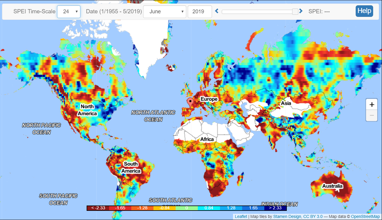 "For more than 35 years, satellites circling the Arctic have detected a 'greening' trend in Earth’s northernmost landscapes. Scientists have attributed this verdant flush to more vigorous plant growth and a longer growing season, propelled by higher temperatures that come with climate change. But recently, satellites have been picking up a decline in tundra greenness in some parts of the Arctic. Those areas appear to be 'browning.'" Loss of insulating snow cover, predation by insects that have also expanded their ranges and flourished, and Arctic wildfires all appear to be contributing to this newly observed browning. www.sciencenews.org/article/climate-change-arctic-browning
A cartogram is a map that has been weighted for a particular variable. This cartogram is weighted to show countries' artificial CO2 (carbon dioxide) emissions since 1850. Additionally, this cartogram labels the 100 companies that, according to the 2017 Carbon Majors Report, account for 71% of global greenhouse gas emissions and names their CEOs. bigthink.com/strange-maps/climate-change
With a bang and a whimper? This article, based on Bill McKibben's new book Falter: Has the Human Game Begun to Play Itself Out?, is not likely to make those already concerned about the potential impacts of climate change feel better. Among the scenarios for disaster planners:
"In 2015, a study in the Journal of Mathematical Biology pointed out that if the world’s oceans kept warming, by 2100 they might become hot enough to 'stop oxygen production by phyto-plankton by disrupting the process of photosynthesis.' Given that two-thirds of the Earth’s oxygen comes from phytoplankton, that would 'likely result in the mass mortality of animals and humans.' A year later, above the Arctic Circle, in Siberia, a heat wave thawed a reindeer carcass that had been trapped in the permafrost. The exposed body released anthrax into nearby water and soil, infecting two thousand reindeer grazing nearby, and they in turn infected some humans; a twelve-year-old boy died. ... [S]cientists have managed to revive an eight-million-year-old bacterium they found beneath the surface of a glacier. Researchers believe there are fragments of the Spanish flu virus, smallpox, and bubonic plague buried in Siberia and Alaska. Or consider this: as ice sheets melt, they take weight off land, and that can trigger earthquakes — seismic activity is already increasing in Greenland and Alaska. Meanwhile, the added weight of the new seawater starts to bend the Earth’s crust. 'That will give you a massive increase in volcanic activity. It’ll activate faults to create earthquakes, submarine landslides, tsunamis, the whole lot,' explained the director of University College London’s Hazard Centre. Such a landslide happened in Scandinavia about eight thousand years ago, as the last Ice Age retreated and a Kentucky-size section of Norway’s continental shelf gave way ... wiping all signs of life from coastal Norway to Greenland and 'drowning the Wales-sized landmass that once connected Britain to the Netherlands, Denmark, and Germany.' When the waves hit the Shetlands, they were sixty-five feet high." www.rollingstone.com/politics/politics-features/bill-mckibben-falter-climate-change-817310/ |
Blog sharing news about geography, philosophy, world affairs, and outside-the-box learning
Archives
December 2023
Categories
All
|
 RSS Feed