|
Here's a thematic map one doesn't see every day: this map shows which parts of the world historically used elephants in battle.
www.reddit.com/r/MapPorn/comments/c6ifji/historical_range_of_the_use_of_war_elephants/
0 Comments
This GIF tracks U.S. population density from 1790 to 2010: www.reddit.com/r/MapPorn/comments/aji8zx/us_population_changes/
Most modern maps conventionally show north at the top of the map, with east to the right, south at the bottom, and west to the left. This was not always the case. During the Middle Ages, world maps often adopted what is known as the O-T design, with east (Asia) at the top of the map, south (Africa) in the lower right quadrant of the map, and north/west (Europe) in the lower left quadrant of the map, separated by a T of water (the Mediterranean and Red Sea). This was done in order to place Jerusalem at the center of the map. The Hereford (UK) Mappa Mundi ("map of the world") is the largest extant example: www.researchgate.net/profile/Qian_Sun15/publication/319561588/figure/fig1/AS:631640015515651@1527606123196/Hereford-Mappa-Mundi-One-of-the-most-famous-medieval-maps-in-existence-dates-from.png
This map shows the world's landlocked countries. Several of these countries, including Ethiopia, the world's most populous landlocked country, became landlocked as the result of border changes (typically following from war or collapse of empire) that left them without access to the sea. worldpopulationreview.com/countries/landlocked-countries/
This mesmerizing geo-graphic from the Financial Times (UK) tracks the rise and fall of the world's 10 most populous cities from 1500 to 2018. Have the sound turned on for the narration. next-media-api.ft.com/renditions/15530111823550/1920x1080.mp4
This article from The Houston Chronicle looks at how the geography of barbecue evolved. "In the beginning, Texas barbecue was rural. From the mid- to late-1800s, small towns grew up along trade routes, especially the rapidly expanding network of railroads. In towns such as Taylor, railroads exported the agricultural bounty of the region, mainly cotton in the early days and, later, cattle. At the same time, Czech and German immigrants landing in Galveston made their way west along the San Felipe Trail, settling among the prosperous farms and ranches of Central Texas. They brought with them the butchery and cooking skills of their homeland, and many opened meat markets to take advantage of the area’s plentiful cattle. Every Saturday or Sunday, the freshly butchered meat of the week before — now facing spoilage in the era before refrigeration — was cooked in brick fire pits and sold to locals and itinerant workers as a weekend lunch or supper special. The story of Texas barbecue was established. By the early 1900s, as the state’s population migrated to rapidly growing urban areas, barbecue followed. By 1913, a Houston city directory listed 15 barbecue stands. Ten of these were owned by African-Americans, reflecting the migration of former slaves from rural to urban areas after the Emancipation Proclamation, bringing with them the open-pit cooking methods of the southern United States. Indeed, African-American-owned barbecue restaurants became associated with urban areas, with celebrated smoked-meat purveyors becoming entrenched in cities including Houston, Chicago and Kansas City, Mo." www.houstonchronicle.com/entertainment/restaurants-bars/bbq/article/The-shifting-geography-of-barbecue-in-Texas-13656406.php
As students in my "Hands-On Geography" classes know, even physical geography is subject to change over time. This interactive mapping tool allows users to see how any given address has changed position over the last 750 million years: dinosaurpictures.org/ancient-earth#0
When India and Pakistan became independent of the UK in 1947, the maharaja of the state of Jammu and Kashmir had to make a choice: join India, join Pakistan, or try to go it alone? This article from National Geographic is an excellent primer on that pivotal moment in the history of Kashmir and the issues that forced the maharaja's hand: www.nationalgeographic.com/culture/2019/03/kashmir-conflict-how-did-it-start
History and science suggest a number of options for cooling the Earth's climate. Unfortunately, none of them -- a nuclear winter, major volcanic explosions, shifts in tectonic plates to obstruct ocean currents -- are very positive. To this list, we can add another: wiping out human populations to impact agriculture. Scientists at University College London have concluded that disease introduced to the Americas at the end of the 15th century reduced native populations and agriculture to such an extent that North American forests reasserted themselves, and the Earth cooled in response to the lower levels of carbon dioxide. www.bbc.com/news/science-environment-47063973
China's recent unmanned landing of a craft on the far side of the moon has reignited discussion of all things lunar. This geo-graphic compares the surface area of the moon to the territory of the world's biggest empires -- and finds the moon to be only slightly larger than the British Empire in 1920. (Relative sizes of other empires, including the Mongol, Russian, Spanish, Abbasid, etc. are listed in the linked article.) brilliantmaps.com/british-empire-moon/#more-3949
The Sahara is the second largest desert on earth, but that was not always the case. More interestingly, it may not be the case in the future either. "[R]esearchers at MIT have analyzed dust deposited off the coast of west Africa over the last 240,000 years, and found that the Sahara, and North Africa in general, has swung between wet and dry climates every 20,000 years. They say that this climatic pendulum is mainly driven by changes to the Earth's axis as the planet orbits the sun, which in turn affect the distribution of sunlight between seasons -- every 20,000 years, the Earth swings from more sunlight in summer to less, and back again. For North Africa, it is likely that, when the Earth is tilted to receive maximum summer sunlight with each orbit around the sun, this increased solar flux intensifies the region's monsoon activity, which in turn makes for a wetter, 'greener' Sahara. When the planet's axis swings toward an angle that reduces the amount of incoming summer sunlight, monsoon activity weakens, producing a drier climate similar to what we see today." news.mit.edu/2019/study-regulating-north-african-climate-0102
Earlier this week, Turkey demanded that Google remove a map of Greater Kurdistan. Google complied. The original map can be seen here in this article from a Turkish newspaper: www.hurriyetdailynews.com/turkey-demands-google-to-remove-kurdistan-map-minister-139999 (Wikipedia continues to include maps of Greater Kurdistan in its entry on Kurdistan.)
Next Sunday marks the 157-year anniversary of the warm rain that triggered what may have been the worst flooding episode in U.S. history: California's Great Flood of 1862. Early and heavy snowfall in Northern California and the Sierra Nevada mountains in late 1861 was suddenly melted by a warm "pineapple express" storm, flooding California's Central Valley and creating a "lake" 300 miles long and 20 miles wide down the middle of the state. The capital had to be moved from Sacramento, parts of which were under 30 feet of water, for several months, and regions of the Central Valley were uninhabitable until mid 1862. Because of the state's geography, a similar flooding event is considered by scientists to be a matter of when, not if. activenorcal.com/remembering-the-great-flood-that-put-northern-california-under-30-feet-of-water (Never heard of a pineapple express? Then you weren't reading this blog in January 2017 :-): www.learningoutsidethebox.net/blog/maps-in-the-news2813234.)
This data-rich GIF from the Pew Research Center shows each state's primary source of immigrants from 1850-2013. www.pewresearch.org/fact-tank/2015/10/07/a-shift-from-germany-to-mexico-for-americas-immigrants/ft_15-09-28_immigationmapsgif/
This map looks at territory once controlled by Iranic peoples (e.g., Persians, Bactrians, Scythians, Alans, Pashtuns).
www.reddit.com/r/MapPorn/comments/9pyfd4/lands_ever_historically_inhabited_and_or/ Archaeologists are scrambling to study and preserve artifacts from Jamestown, the first permanent English settlement in North America, and other sites along the East Coast as storms and rising seas erode the settlements of Native Americans and early colonists. "Throughout human history, the water's edge has been an inviting place to settle," Martin Gallivan, a professor of anthropology at the College of William & Mary, told Bay Journal, making structures and artifacts at these early waterfront settlements particularly vulnerable to the next storm. Archaeologists excavating at Jamestown, for example, "now factor in elevation and water levels when considering where to work next on a site that is increasingly inundated with water." Longwood University's Institute of Archaeology has found that 153 of the 313 Virginian archaeological sites it was asked by the state to study are threatened by coastal erosion and rising seas, with 28 of these sites likely to disappear within 50 years.
www.bayjournal.com/article/gone_with_the_waves_storms_rising_waters_threaten_pieces_of_past This interactive mapping site allows you to enter any location in North America, Australia, or New Zealand, as well as parts of South America and Greenland, to find out which indigenous people(s) used to live where you do now. native-land.ca/
Next year, 2019, will mark the 400-year anniversary of the first purchase of African slaves in what is now the United States. But the history of the trans-Atlantic slave trade goes back at least another hundred years, primarily under the Portuguese (and primarily to Brazil). This map highlights the impact of the slave trade on African kingdoms. Part of modern-day Angola, for example, shows up to 4 million people captured and shipped across the Atlantic. www.reddit.com/r/MapPorn/comments/9g5how/slaves_taken_from_regions_of_africa_1229_x_869/
Prior to 1917, the Russian empire accounted for roughly 1/7 of the earth's land mass. When it collapsed in the wake of the Russian Revolution, many groups and peoples tried to claim a stake for themselves. This map looks at some of those short-lived "states." www.mapmania.org/static/map/original/weird_short-lived_states_of_the_russian_civil_war_69700.png
The Nok Caves, a UNESCO World Heritage Site in northern Togo, might look a bit like the cliff dwellings of Mesa Verde, for example, but they were built by Togo's Moba people in the 18th and 19th centuries for a very different purpose: instead of being permanent dwellings, the Nok Caves served as a well-stocked hiding place whenever an enemy tribe raided Moba villages to find people to sell to slave traders in exchange for guns and horses. www.atlasobscura.com/places/nok-caves
To provide context for globalization, some of my "Hands-On Geography" classes study historical trade routes, and this map provides a nice look at trade networks crisscrossing the Eastern Hemisphere about 1,000 years ago. (Click on the link to see the zoomable map.) merchantmachine.co.uk/medieval-trade-routes/
Since the subsections of what is today Cameroon merged following their independence from Britain and France in the early 1960s, the country has been officially bilingual. But the geographically smaller, less populous English-speaking part of the country has burbled with talk of secession on and off for decades, most recently re-emerging in late 2016 and escalating over the last nine months. This map shows the French-speaking regions of Cameroon in light blue and the two English-speaking regions of Cameroon in light red. upload.wikimedia.org/wikipedia/commons/thumb/6/62/Langues_du_Cameroun_Carte.png/450px-Langues_du_Cameroun_Carte.png 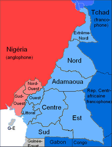 The demand of growing populations for water has meant diverting rivers that once fed lakes. This article profiles California's shrinking Salton Sea and the consequences of its decline.
"An enormous blue void at the north end of the Imperial Valley, the Salton Sea once attracted more visitors than Yosemite. But California’s largest lake is now mostly forgotten, and those who know of it don’t have flattering things to say: they’ll tell you about vast beaches where the sand is made of fish bones; about eerie, half-abandoned Mad Max-esque communities; and most of all, its noxious emissions. In 2012, the Salton Sea burped up a cloud of sulfurous odor so thick that residents in Los Angeles 150 miles away were hit by the nauseating smell of rotten eggs. Though it’s been shrinking for decades, on January 1st, 2018, the Salton Sea entered a nosedive. Thanks to a water transfer agreement with San Diego, 40 percent less water will now flow into the sea. It will recede dramatically, and its already shallow surface level will drop 20 feet. By 2045, its waters will be five times as salty as the Pacific Ocean, killing whatever fish still live there and scattering the birds that feed on them. Though we often think of lakes as permanent landmarks, global warming, irrigation, and our constant thirst threaten these resources around the world. Terminal lakes like the Salton Sea, bodies of water that have no natural drain, are particularly vulnerable. Iran’s Lake Urmia — once the largest body of water in the Middle East — has shrunk by almost 90 percent over the last 30 years; Africa’s Lake Chad is also 90 percent smaller than it was in the 1960s; and Kazakhstan’s Aral Sea, once the fourth largest salt lake in the world, has practically been wiped off the map. When these lakes evaporate, they can upend industries and erase surrounding communities. For residents near the Salton Sea, the most pressing problem is the threat of toxic dust. The receding Salton Sea will reveal at least 75 square miles of playa, the lake bed that the water once hid. When that soil dries, it will begin to emit dust laced with industrial runoff from the surrounding farms: up to 100 tons of dust could blow off the playa daily." www.theverge.com/2018/6/6/17433294/salton-sea-crisis-drying-up-asthma-toxic-dust-pictures This GIF shows U.S. claims to Native American land between 1810 and 1891. www.reddit.com/r/MapPorn/comments/8j1w1k/seizure_of_native_american_land_in_the_us_between/
Stepwells were designed to provide easy-to-access, year-round water supplies and are found primarily in South Asia. Many Indian stepwells are elaborately decorated structures, but only one has been declared a UNESCO World Heritage Site: Rani Ki Vav (or "the queen's stepwell") in Gujarat. Rani Ki Vav was built as a seven-story inverted Hindu temple, probably in the 11th or 12th century, with more than a thousand sculptures representing religious and literary figures carved into the natural sandstone. Changes to the flow of the nearby Saraswati River caused the stepwell to flood and silt to accumulate, and Rani Ki Vav was only excavated and restored in the late 1980s. www.atlasobscura.com/places/rani-ki-vav
|
Blog sharing news about geography, philosophy, world affairs, and outside-the-box learning
Archives
December 2023
Categories
All
|
 RSS Feed