|
The king of the small African country bordering South Africa and Mozambique has announced that the country is returning to its pre-colonial name: Swaziland is now eSwatini. Nearly 50 years after the country's independence from Britain, the country is reclaiming its traditional name. geographical.co.uk/geopolitics/geopolitics/item/2708-swaziland-renamed-the-kingdom-of-eswatini
0 Comments
Despite the current uptick in tensions, distrust of Russia is nothing new. This map from 1957 shows areas (in pink) and specific sites (in red) that were off limits to anyone with a Soviet passport. news.nationalgeographic.com/2018/03/russia-cold-war-travel-ban-maps-red-scare
When Europeans arrived in Rapa Nui (also known as Easter Island) in on Easter Sunday 1722, they were astonished to find the island already had a native community numbering in the thousands. Famous for the giant stone heads (moai) rimming its coastline, Easter Island not only was the most remote populated island in the world, it was likely one of the last places settled by humans (about 900 years ago). Although culturally part of Polynesia, today Easter Island is administered by Chile. More people are using simple DNA kits to check their family ancestries, and many of those who claim Irish ancestry are surprised to see Nordic DNA pop up in their profiles. But many of Ireland's major population centers, including Dublin, were founded by the Vikings. This map shows Ireland c. 950, with Viking holdings in green. www.wesleyjohnston.com/users/ireland/maps/historical/map950.gif
In honor of Presidents' Day, this map shows the birthplace of all U.S. presidents through Barack Obama. (Donald Trump, like Martin Van Buren, Millard Fillmore, and both Roosevelts, was born in New York.) www.livescience.com/53372-presidential-birth-places.html
The efforts of Catalonia to separate from the rest of Spain continue to make headlines, but Spain's headache is one many other European countries share. This map looks at separatist movements across Europe, and the accompanying article from The Guardian (UK) provides information on each one:
www.theguardian.com/world/ng-interactive/2017/oct/27/beyond-catalonia-pro-independence-movements-in-europe-map The black pepper we eat today is actually not the black pepper that spurred the spice trade more than 2,000 years ago. This interesting article looks at the reasons why Europeans switched from one Indian pepper to another. (Geographically relevant hint: sea routes result in cheaper goods than overland routes.) www.atlasobscura.com/articles/how-black-pepper-won-europe-from-a-better-pepper
This map from the Library of Congress shows "judicially established Indian land areas" as of 1978, the year the Indian Claims Commission expired. The commission was created after WWII to thank Native Americans for their service during the war. Native peoples did not regain any lands lost over the prior three centuries, but the U.S. government did provide a monetary settlement based on this map. tile.loc.gov/image-services/iiif/service:gmd:gmd370:g3701:g3701e:ct008649/full/pct:12.5/0/default.jpg 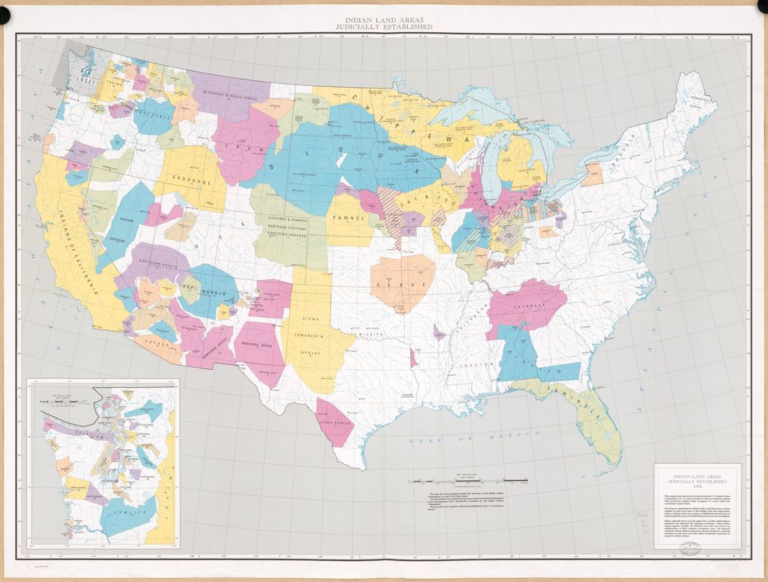 Today is the anniversary of the armistice ending World War I. As part of the agreement ending the war, Germany lost its colonies in Africa and Micronesia and the Ottoman and Austro-Hungarian empires were broken up. This map shows the ethno-linguistic composition of Austro-Hungary before the war began. cdn0.vox-cdn.com/assets/4620799/austria_hungary.png
This interactive map provides information on active conflicts around the world. The size of each dot reflects the duration of the conflict it represents. At the site, click on the dot to find out more about the conflict: its history, opposing goals, deaths, and current status. emmeline.carto.com/viz/b69015da-136a-11e5-a64a-0e43f3deba5a/embed_map
Did a volcano in Sicily bring down a dynasty in Egypt? That's the thesis of new research, based on a comparison of volcanic ash in ice cores and Nile water level records. Major volcanic eruptions are found to disrupt African monsoon patterns, delivering less rain to the Nile and its tributaries. A powerful eruption by Etna in 44 BC likely contributed to the drought, famine, and resulting instability in Egypt over the next several years, making Egypt more vulnerable to Rome's involvement in its internal affairs and leading to the eventual overthrow of its last Ptolemaic ruler, Cleopatra. www.sciencenews.org/article/how-volcanoes-may-have-ended-dynasty-ptolemy-and-cleopatra
If you've ever thought about how cool it would be to overlay a timeline on a map, this is the site for you. TimeGlobe allows you to designate a year or range of years and then shows various world events during that time, mapped to their relevant location. At the site, mouse over each dot for a brief summary or click on the summary to go straight to the Wikipedia article on the event. Especially useful for understanding the geography driving regional issues. timeglo.be/
At first glance, people tend to think this is an image of rice terraces somewhere in Asia. In fact, these are the famous salt pans of Maras, southeast of Lima, Peru. In use since the region was ruled by the Inca, these terraces dam salty stream water, which evaporates and allows for the collection of the salt. For some tourists, the salt pans of Maras are more impressive than the nearby ruins of Machu Picchu. www.atlasobscura.com/places/salt-pans-of-maras
A months-long civil protest, focused primarily in the mountainous region of northern Morocco known as the Rif, has gone all but unnoticed in the U.S. Protesters in Rif are objecting to police brutality, but this is just the latest chapter in Rif's estrangement from the rest of Morocco. Not only is the region mountainous, it is historically Berber, not Arab, and was a Spanish, not French, colony prior to independence in 1956, putting it at a geographic, linguistic, ethnic, and economic disadvantage when the country was re-unified. Even though Rif has a relatively small population, it has produced most of the Moroccan immigrants to Western Europe. This map shows the former colony of Spanish Morocco and the independent city of Tangier with, outlined in red, the once-aspirational Republic of Rif. upload.wikimedia.org/wikipedia/commons/thumb/4/43/Rep%C3%BAblica_del_Rif.svg/2000px-Rep%C3%BAblica_del_Rif.svg.png 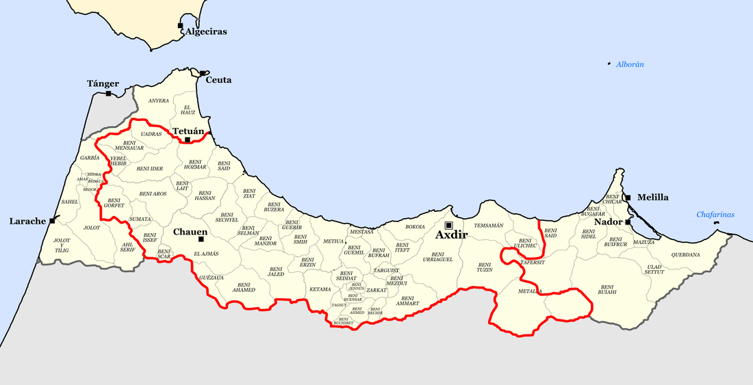 Thirty-three countries have land below sea level, but more than 25% of the Netherlands is below sea level. This map looks at the history of Dutch land reclamation from the late Middle Ages to today. The newest Dutch province, Flevoland, was created in 1986 from land reclaimed in the 1950s and '60s. brilliantmaps.com/wp-content/uploads/netherlands-reclaimed-timeline.png 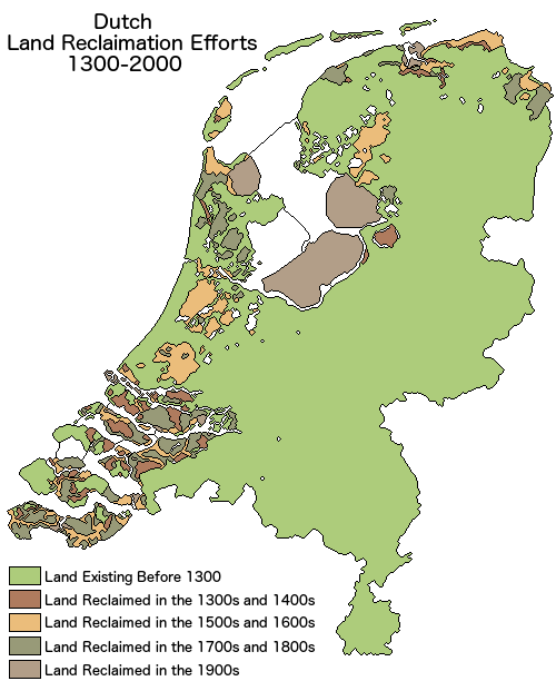 Tomorrow is the 80th anniversary of the disappearance of Amelia Earhart. Earhart and her navigator were attempting to fly around the world when their plane went missing. On July 2, 1937, they left Lae, eastern New Guinea (then a British possession governed by Australia), heading east towards Howland Island (a tiny uninhabited coral island administered by the U.S.), where they intended to refuel. They never arrived and are generally assumed to have missed the island -- it's only about 1.75 square miles -- and run out of fuel somewhere in the Pacific. See if you can find Howland Island! www.jarvisisland.info/maps/oceania.gif
This animation shows the emergence of U.S. political boundaries over time, which closely tracks settlement, from the early 1800s to 2000. i.redd.it/uatjbhm50g2z.gif
Earlier this week, I shared a map showing China's deserts encroaching on the current capital, Beijing. The Chinese government recently announced plans for a secondary "capital" two hours south of Beijing. The newly-created city of Xiongan will be twice the size of NYC, and planners hope many of Beijing's universities and businesses (and their attendant people and traffic) will move to Xiongan. Beijing was declared the capital of China by the People's Republic in 1949, but Beijing, while always a seat of power, has not always been China's capital. The name Beijing means "northern capital," to distinguish it from Nanjing, which has also been China's capital and means "southern capital." Xi'an (also known as Chang'an and now famous as the home of the Terracotta Army) served as China's capital for longer than any other city, more than 1,000 years. This map shows major historic capitals of China. upload.wikimedia.org/wikipedia/commons/thumb/4/4c/Historicalcapitalsofchina_ancient.png/800px-Historicalcapitalsofchina_ancient.png 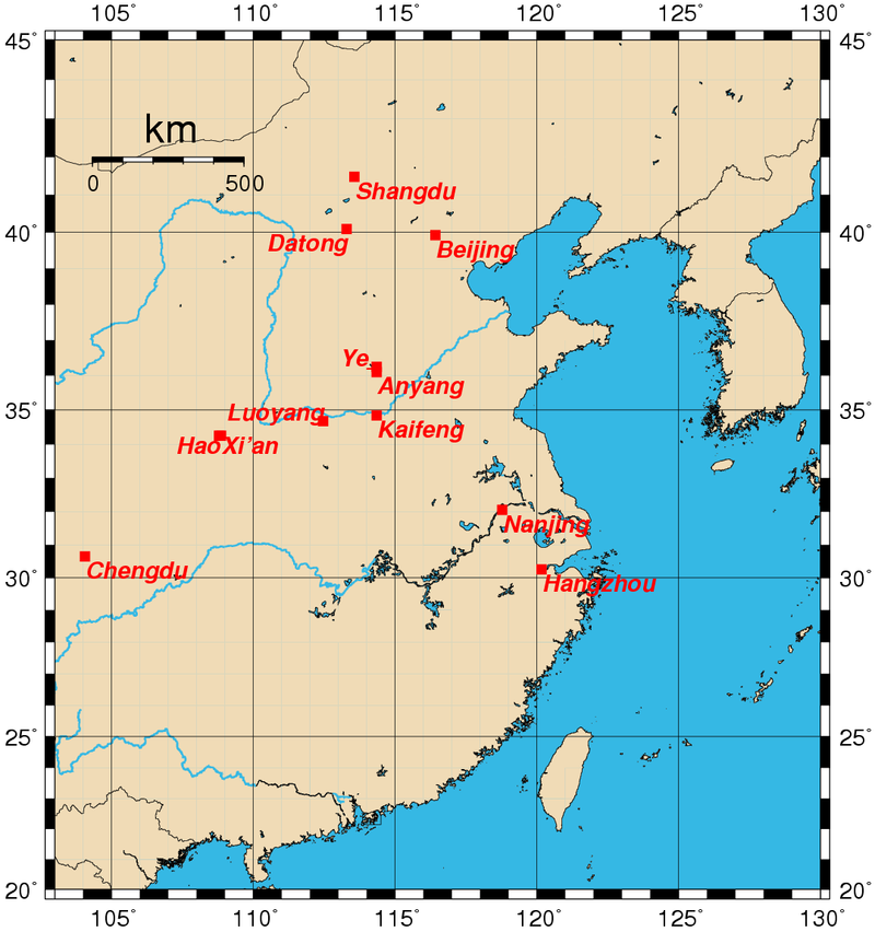 Western Sahara and its Sahrawi people have been in the news lately. But what is Western Sahara anyway? Western Sahara is a region along the Atlantic Ocean claimed by Morocco and bordered by Morocco, Algeria, and Mauritania. It had been a Spanish colony (and may be shown as "Spanish Sahara" on older maps). However, when other European countries were under pressure to give up their colonies after WWII, Spain, governed by its long-time military dictator, Francisco Franco, did not. It was not until the month Franco died, in November 1975, that Spain finally agreed to relinquish its control of Western Sahara. Morocco and Mauritania immediately claimed portions of Western Sahara for themselves, over the objections of the native Sahrawi people. Morocco eventually won out, and tens of thousands of Sahrawi continue to live in refugee camps in Algeria, which has been a key sponsor of the Polisario Front, the Sahrawi resistance movement fighting for Western Sahara's independence. Western Sahara is the most populous territory on the United Nation's list of Non-Self-Governing Territories. c8.alamy.com/comp/GA4ER8/western-sahara-political-map-with-capital-laayoune-national-borders-GA4ER8.jpg
The Caucasus, the mountainous region between the Black Sea and the Caspian Sea that bridges Europe and Asia, has long been the frontier of empires, from the Assyrian to the Persian to the Mongol to the Ottoman to the Russian, with a sprinkling of indigenous kingdoms throughout. The region's complicated past has made the Caucasus one of the most linguistically diverse places on the planet, as shown on this map. 4.bp.blogspot.com/-fgHPr4ylKT8/T9D96BKdc5I/AAAAAAAAE38/lkrPRFqIuOs/s1600/CaucasusLayout_rev.png
Yellowstone is perhaps the largest and most famous supervolcano, but it is a supervolcano near Naples, Italy, whose recent rumblings are concerning scientists. The last eruption of Campi Flegrei, the Italian supervolcano, may have contributed to the end of the Neanderthals. The map below shows the locations of the world's supervolcanoes. (The red VEI-8 volcanoes have historically produced larger eruptions than the orange VEI-7 volcanoes.) To read more about Campi Flegrei, whose name means "fields of fire," see news.nationalgeographic.com/2016/12/supervolcano-campi-flegrei-stirs-under-naples-italy/
Students in one of my classes design their own city on the last day of class, and, invariably, they design a city with streets. But one of the earliest examples of a city -- Catalhöyük, in south-central Turkey -- was built without streets: people walked over the roofs of the buildings and entered the buildings via holes in the roof! Catalhöyük was declared a UNESCO World Heritage Site in 2012. www.catalhoyuk.com/site/architecture
Where to put an extra 2+ billion people by 2050? One intriguing possibility is where humans have chosen to live on occasion previously: underground. Rediscovered in the 1960s, Derinkuyu, in central Turkey, is one example of an ancient underground city, at one time housing more than 15,000 people and their animals across multiple levels. https://www.thevintagenews.com/2016/07/05/ancient-underground-city-discovered-beneath-a-house-in-anatolia-turkey-2/
Cristoforo Colombo may have been Spanish, not Italian, and may have deserved condemnation not a holiday, but at least the routes of his voyages are not disputed. This map shows all four of his trips from Spain to the Americas via the Canary Islands. media.web.britannica.com/eb-media/56/89956-004-9851B885.gif
Earlier this week the Daily Mail (UK) published this map showing the world's largest city at different intervals across 10,000 years of human history. www.dailymail.co.uk/travel/travel_news/article-3802506/From-Jericho-Tokyo-Map-reveals-cities-largest-world-one-held-title-just-1-000-inhabitants.html
|
Blog sharing news about geography, philosophy, world affairs, and outside-the-box learning
Archives
December 2023
Categories
All
|
 RSS Feed