|
The U.S. presidential election is two months away. This article interviews legal, civil liberties, and national security experts to discuss the election scenarios that keep them up at night and how they might be prevented, should there be the political will to do so: slate.com/news-and-politics/2020/08/election-nightmares-experts.html
0 Comments
In late 1991, the Soviet Union was dissolved, and the Soviet republics became 15 independent countries. All 15 countries have had "elections" -- including, most recently, Belarus, where thousands of people have taken to the street to protest the Aug. 9 election in which the president who has been in power since 1994 received 80% of the vote. But as this geo-graphic, based on data from the Bertelsmann Transformation Index, shows, none of the former Soviet republics (except the Baltic countries of Estonia, Latvia, and Lithuania) score above "limited" in assessments of their transition to democracy and a market economy. Belarus is "very limited." www.statista.com/chart/22584/post-soviet-democracy
The U.S. presidential election is 3 months away. Political geographers are intensely interested in not just polling data but also where donations are coming from. This map from The New York Times shows where donations to the Trump (red) and Biden (blue) campaigns came from April through June by zip code. The article also contains enlarged maps of a sampling of key states. www.nytimes.com/interactive/2020/07/24/us/politics/trump-biden-campaign-donors.html
In a ruling that surprised many earlier this week, the U.S. Supreme Court ruled 5-4 that Oklahoma statehood in 1907 did not abrogate the U.S. government's treaty from the 1830s with the Muscogee (Creek) Indians that promised the tribe a chunk of eastern Oklahoma, including land that today includes parts of Tulsa, Oklahoma's second-largest city. The ruling also provides precedent for land allotted to the Cherokee, Chickasaw, Choctaw, and Seminole tribes, which collectively, as this map from The Wall Street Journal shows, may be entitled to more than half of Oklahoma. (from www.wsj.com/articles/american-indian-lands-include-eastern-oklahoma-supreme-court-rules-11594304003)
This map from Foreign Policy shows where national or regional elections have already been postponed (yellow) or rescheduled (blue) due to the coronavirus pandemic. (For details, check out the article itself: foreignpolicy.com/2020/05/22/coronavirus-elections-postponed-rescheduled-covid-vote)
If you've ever looked at a map of Minnesota, you may have noticed the "bump" at the top, just west of center. If you look more carefully, you will notice that the land part of that bump is actually detached from the rest of the state. That bit of land is known as the Northwest Angle. It is the northernmost point in the lower 48 states and effectively an exclave of the U.S. The 120 or so permanent residents make most of their money providing services for recreational fishermen. June is normally their busiest month, but with the U.S-Canada border still closed because of COVID-19, business is slow. At present, Americans can only access the Northwest Angle via boat across the large and sometimes temperamental Lake of the Woods. www.nationsonline.org/maps/USA/Minnesota_map.jpg
Was it just your imagination that our response to the coronavirus took on a partisan political tone? According to political scientists at Princeton and Queens College (New York), it was not your imagination. An analysis of Google Mobility Reports collected from Feb. 15 to Apr. 26 allowed researchers to compare patterns of movement before and after the coronavirus state of emergency. Before March 13, patterns of movement in Democratic counties (in which Donald Trump received <20% of the vote in 2016) and Republican counties (in which Donald Trump received >80% of the vote in 2016) were very similar. After March 13, though, movement in Democratic counties fell 14 percentage points more than movement in Republican counties did, even when adjusting for population density, education, age, and race. The gap remained persistent, regardless of rise in COVID-19 cases or governors' orders. "Even when a governor issued a directive to stay home, the pattern remained: Pro-Trump counties with low education [defined by researchers as having at least 5% more high school dropouts than college graduates] were much less likely to change their behavior than others." www.washingtonpost.com/politics/2020/05/14/where-are-people-less-likely-obey-coronavirus-restrictions-republican-counties/
These maps from a recent New York Times article look at "upmarket bubbles" (locations that are five miles or less from a Whole Foods, Lululemon, Apple store, or Urban Outfitters) vs. "down-home zones" (locations that are at least five miles from an upmarket bubble and within 10 miles of a Bass Pro Shop, Hobby Lobby, Cracker Barrel, or Tractor Supply). In 2016, 34% of American voters lived in an upmarket bubble and 50% lived in a down-home zone. www.nytimes.com/interactive/2020/02/27/upshot/democrats-may-need-to-break-out-of-the-whole-foods-bubble.html
"Social distancing" and voting do not go particularly well together. This map shows (in blue) the states that have not yet held their 2020 primary elections. The states with a red check mark are scheduled to do so tomorrow (March 17). 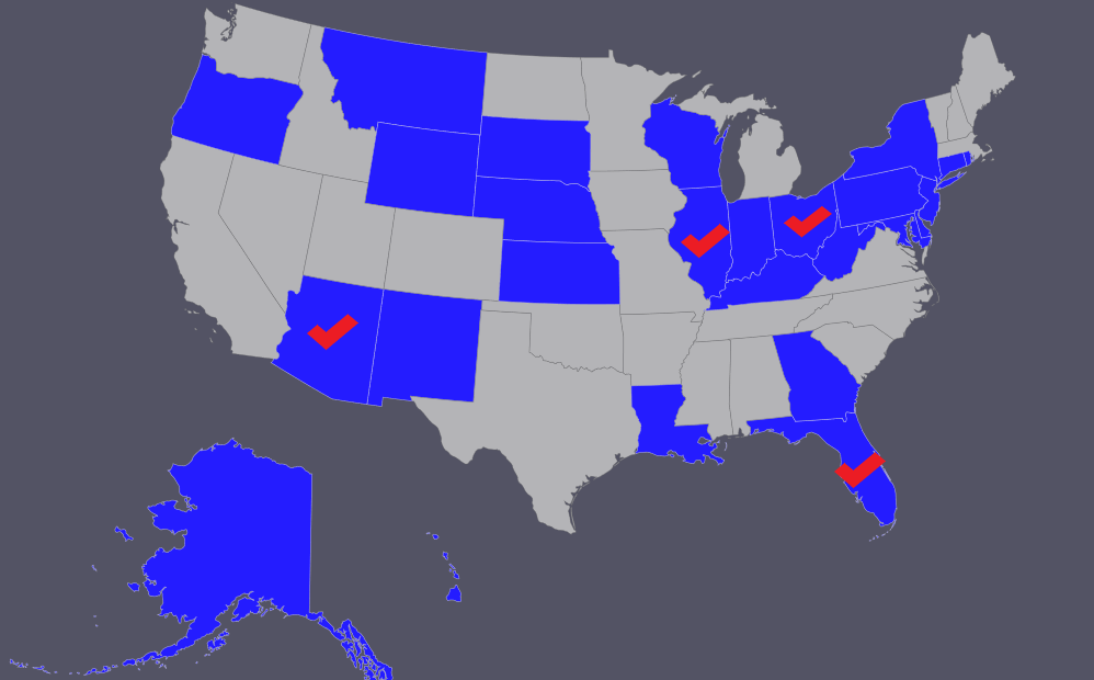 As students in my geography classes learn, maps change not only across time but also across place: a map produced in one country might not show political borders in the same way a map produced in another country with different ideas about those borders does. Perhaps it should come as no surprise then, that Google Maps is showing different maps to different users, based on the location of the user. This article includes images of Google's differing maps of Kashmir, Western Sahara, and Ukraine, for example. www.washingtonpost.com/technology/2020/02/14/google-maps-political-borders/
Presidents' Day celebrates the February birthdays of George Washington and Abraham Lincoln, which reminds us (in case we somehow forgot) that this is a presidential election year. The biggest prize of the primary season is Super Tuesday: on March 3, all of the states shown in blue on this map will be having their primaries. fivethirtyeight.com/wp-content/uploads/2019/12/SUPER-TUESDAY-POLLS-fixed-4x3.png
The Trump Administration recently suspended visas for citizens from six additional countries: Eritrea, Kyrgyzstan, Myanmar, Nigeria, Sudan, and Tanzania. All of the countries highlighted on this map are now subject to travel "bans" of one kind or another. The countries in green are predominantly Muslim; the countries in yellow are not. (Nigeria has a Muslim majority with a large Christian minority; Tanzania has a Christian majority with a large Muslim minority.) 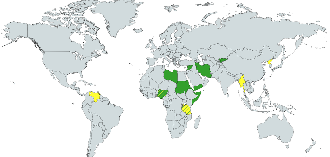 The anti-corruption NGO Transparency International just released its 2019 Corruption Perceptions Index. The index ranks 180 countries and territories on perceived government corruption, and it is worth digging through the data. (Spoiler alert: the U.S. has fallen to 69 out of a possible 100, down from 76 in 2015 and putting it behind Uruguay and the UAE.) www.transparency.org/cpi2019
The state of Hawaii is generally shown on maps as stretching from the island of Kauai in the northwest to the island of Hawaii ("the Big Island") in the southeast. In fact, the state's territory extends past Midway Atoll, nearly 1,000 miles to the northwest. This map shows the actual territory of Hawaii (although Midway itself is part of a different U.S. political entity). www.soest.hawaii.edu/pibhmc/NWHI_images/NWHI.jpg
This map, based on data from Freedom House, shows the state of individual political freedom and civil liberties around the world in 2019. www.axios.com/freedom-house-freedom-around-the-world-map-6eb67eab-a1a0-4e40-8c7b-baeaae307935.html
The Kali River has long been recognized as the border between western Nepal and India. But where, exactly, does the Kali River start? India and Nepal have traditionally had somewhat different answers to that question, which puts the small (38 square km) Himalayan territory of Kalapani in dispute. Although India has administered Kalapani for decades and has had troops in the region since its brief 1962 war with China, India and Nepal have engaged in intermittent negotiations over Kalapani's status for years. A few days ago, though, the Indian government released a new map, reflecting its earlier decision to divide the state of Jammu and Kashmir into the territories of Jammu and Kashmir and Ladakh, and this new map shows Kalapani as Indian territory, despite Nepal's protests that Kalapani belongs to Nepal. The release of the map, the northern part of which is shown here, has itself created a diplomatic kerfuffle. (The new territory of Jammu and Kashmir is shown in salmon; Ladakh is shown in turquoise north and east of it; Uttarakhand, which includes Kalapani, is shown in pink to the west of Nepal. Kalapani itself would be in the far northeast corner of Uttarakhand.) images.indianexpress.com/2019/11/INDIA-NEW-MAP-nepal.jpg
According to data collected from the National Conference of State Legislatures, 2019 marked the first time in over a century that one political party, be it Republican (in red on this map) or Democrat (in blue on this map), controlled both houses of the state legislature in every state save one. images.centerdigitaled.com/images/GOV01_44_Legislatures.jpg
Earlier this week, Indonesian president Joko Widodo announced that the government has selected a spot for the country's new capital. (Indonesia's long-time capital of Jakarta, on the island of Java, is both massively crowded and sinking, as discussed in earlier blog posts.) As this map shows, the new capital is to be built 800 miles away on the eastern coast of the island of Borneo, in the Indonesian province of East Kalimantan. Construction at a location between the cities of Samarinda and Balikpapan is supposed to start in 2020 with initial occupancy in 2024. media.zenfs.com/en_us/News/afp.com/9a2d1a72c9fc2dc9273b4c094cd093ec9b42634c.jpg
You probably never thought there was much point to memorizing state nicknames, did you? Fair enough. But if you aren't absolutely sure of a state's nickname, you probably shouldn't use it. Mark Sanford, who is mounting a Republican primary challenge to Pres. Trump, was heading to Iowa recently and asked those with insight on "the Buckeye State" for help. The problem is that Iowa is the Hawkeye State; Ohio is the Buckeye State. You can use this site to check or brush up on your state nicknames: statesymbolsusa.org/categories/nickname
This map looks at states' current treatment of military-style assault weapons and high-capacity ammunition magazines: www.statista.com/chart/18924/states-without-a-ban-on-assault-rifles-and-large-capacity-magazines/
Earlier this week, India announced plans to eliminate political autonomy for the disputed state of Jammu & Kashmir. Since Indian/Pakistani independence in 1947, India and Pakistan have fought four wars, in large part over control of Muslim-majority Kashmir. (The substate of Jammu is Hindu-majority.) This week, India's ruling party announced plans to eliminate the autonomy Jammu & Kashmir has exercised since independence and carve out a Buddhist-majority state (actually, union territory) of Ladakh (part of which is contested by China) and make the rest of Jammu & Kashmir a separate union territory subject to Indian law. This map provides more detail of the proposed change in political geography: i2.wp.com/images.mapsofindia.com/my-india/2019/08/union-territory-of-jammu-and-kashmir.jpg
In 1979, 10 years after the first moon landing, the United Nations adopted the "Agreement Governing the Activities of States on the Moon and Other Celestial Bodies," also known as the Moon Treaty. The treaty was designed to prohibit the militarization, commercialization, and colonization of bodies in our solar system, including the moon, without the consent of the international community. This map looks at the handful of states that are parties to the treaty (in green) or that have signed the treaty but are not necessarily bound by it (in blue). www.statista.com/chart/18738/countries-that-are-signatories-or-parties-to-the-1979-moon-treaty/
What do France, Haiti, and India (shown in red on this map) have in common? Liberté, égalité, and fraternité (or liberty, equality, and fraternity or brotherhood). "Liberté, égalité, fraternité" is the national motto of both France and Haiti. The English equivalent features prominently in the preamble to the Indian constitution. The phrase has its origins in the French Revolution, which will be marked in France by Bastille Day tomorrow. 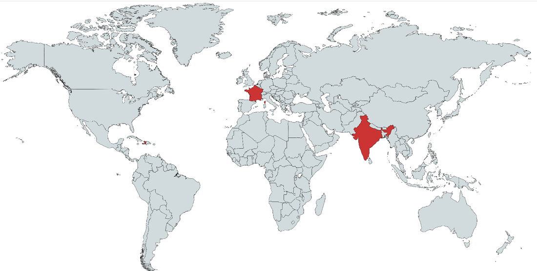 Much was made of the gains by right-wing nationalist/populist parties in the recent European Parliament elections (which went from a total of 78 seats in the 751-person body to 112). Comparatively less was said about the liberal parties' gains: the Green Party and the Alliance for Liberals and Democrats for Europe expanded their representation in the European Parliament from 52 and 68 seats, respectively, to 69 and 105. This pair of maps, from BBC News (UK), shows where the Greens and ALDE drew votes. ichef.bbci.co.uk/news/624/cpsprodpb/2AB4/production/_107123901_13_map_party_strength_by_country_alde_green_2019-05-27-nc.png (Here are the maps for the right-wing nationalist and populist voters: ichef.bbci.co.uk/news/624/cpsprodpb/03A4/production/_107123900_13_map_party_strength_by_country_enf_efd_2019-05-27-nc.png)
A cartogram is a map that has been weighted for a particular variable. In this case, the variable is the number of times Donald Trump mentioned the country in a tweet since being elected U.S. president (through May 2019). worldmapper.org/maps/politics-trumptweets-2016to2019/
|
Blog sharing news about geography, philosophy, world affairs, and outside-the-box learning
Archives
December 2023
Categories
All
|
 RSS Feed