|
The Turkish government wants you to call the country "Türkiye" instead of "Turkey." Although Türkiye (formally, Türkiye Cumhuriyeti or Republic of Turkey) is what the country has called itself since 1923, maps in the English-speaking world have always used Turkey. This article explains the reasons behind the change and includes a YouTube clip featuring the correct pronunciation of "Türkiye," which may or may not catch on in the U.S.: www.afar.com/magazine/why-turkey-is-now-turkiye
0 Comments
Although neither Finland nor Sweden are members of NATO, both countries have recently mentioned the possibility of joining the security alliance, in defiance of Russia's warnings against doing so. This map shows NATO's current members, highlighting members that have joined since the collapse of the Soviet Union. (Map from www.wsj.com/articles/the-betrayal-myth-behind-putins-brinkmanship-11641568161.)
These maps from The New York Times detail Russian military positions on Ukraine's northern, eastern, and southern borders: www.nytimes.com/interactive/2022/01/07/world/europe/ukraine-maps.html
Although Barbados achieved independence in 1966, the island elected to remain a constitutional monarchy with Britain's Queen Elizabeth II as its titular head. Only recently, 55 years later, did Barbados choose to become an independent republic (while remaining part of the Commonwealth). This map from Statista shows countries that used to be part of the British Empire: www.statista.com/chart/26297/countries-gained-independence-from-the-uk/
In the recent fishing disputes between the UK and France, it is helpful to throw in Jersey and Guernsey as well. Both are islands in the English Channel, much closer to France than to Britain as this map shows. Although both are Crown Dependencies, neither is formally part of the UK, instead having their own governments, treaties, and territorial waters. Because they are not part of the UK, Jersey and Guernsey were never part of the EU either. Post-Brexit, fishing in the English Channel now requires navigating multiple sets of rules and permits issued variously by France, Britain, Jersey, and Guernsey. upload.wikimedia.org/wikipedia/commons/e/ec/ChannelIslands.png
Melbourne, Australia, just finished the world's longest COVID lockdown to date. This geo-graphic shows cumulative days of COVID lockdowns by various jurisdictions around the world: www.statista.com/chart/26023/areas-with-the-longest-cumulative-pandemic-lockdowns. (It is expected that the emergence of the so-called Delta-plus variant in the UK may result in one or more of the UK's subdivisions passing Melbourne in the not-too-distant future.)
The world's longest submarine power cable began operation earlier this month. The 450-mile cable between north England and west Norway is designed to help even out green power distribution, sending Norwegian hydropower to the UK and UK wind power to Norway, as needed. An even longer cable is currently in the works between Denmark and the UK. This map from the Financial Times (UK) shows the UK's current and planned underwater power cables. tinyurl.com/rw6um2b7
The North Sea has long been the source of the UK's oil. More recently, it's been the site of the UK's burgeoning wind farms. Last year, wind accounted for 1/4 of the UK's electricity. But when the wind stops blowing unexpectedly, the power grid is sent into turmoil, which is what happened recently: wind speeds in the normally windy North Sea hit their lowest levels in 20 years, more than doubling electricity prices in the UK and sending ripples through the energy markets of France, the Netherlands, and Germany. This article from the Wall Street Journal looks at what happened and the complexity of energy markets: www.wsj.com/articles/energy-prices-in-europe-hit-records-after-wind-stops-blowing-11631528258
This geo-graphic looks at who was granted asylum in the U.S. in FY2019, by country of origin, and how that mix has been changing. www.statista.com/chart/25619/asylum-grants-in-the-us-by-nationality
Scientists from the University of Copenhagen accidentally discovered the world's northernmost island -- and added 20,000 square feet to Denmark's territory in the process -- when they went, by helicopter, to collect biological samples from a remote island off the northeastern coast of Greenland named Oodaaq (shown in green on this map), previously believed to be the world's northernmost island, and instead put down on an as-yet-unnamed mound of silt and gravel 780 m. further north. Islands of sediment shaped by the currents, like the newly discovered island, are often transitory, coming and going with major storm action. 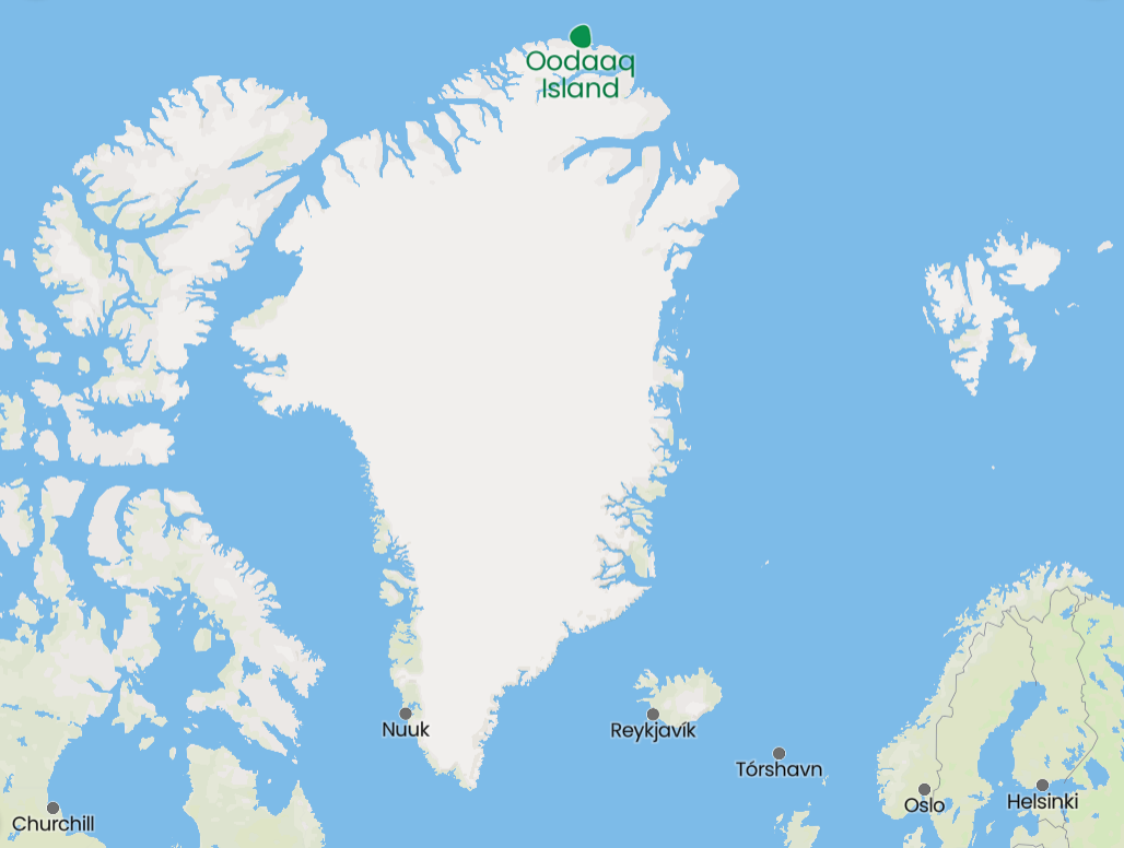 Wildfires in California, British Columbia, Europe, and North Africa regularly make the news. But wildfires burning in Siberia are bigger than all of the others put together. "Siberia is so vast that huge fires can burn without threatening any major settlements, transportation systems or infrastructure — but are still part of a swath of infernos that together are larger than all the other blazes around the world. On one level, the Siberian fires are part of an annual cycle. But many climate experts see the staggering scope of this year’s fires as another sign of greater fire risks on a warming planet that is potentially being made even hotter by huge carbon emissions from the blazes. Russia is fighting more than 190 forest fires in Siberia that have closed airports and roads, forced widespread evacuations and sent a pall of smoke across the North Pole. But it has abandoned dozens more fires covering thousands of square miles, with no effort to fight them. ... More than 8,600 [Russian] firefighters, agricultural workers, soldiers and other emergency workers are fighting forest fires that have burned more than 62,300 square miles since the beginning of the year, according to Greenpeace. That’s an area nearly twice the size of Austria. ... Last year, Russian fires burned 4.7 billion trees, seven times more than were planted, according to a Greenpeace study using satellite images. In one month, Russian fires emitted carbon equal to Sweden’s total carbon dioxide emissions for the year."
www.washingtonpost.com/world/2021/08/11/siberia-fires-russia-climate/ As we are already seeing, changes in the climate do not have the same impact across all regions. This geo-graphic from Statista summarizes the changes in key elements of physical geography -- precipitation patterns and temperature -- forecast in this week's Intergovernmental Panel on Climate Change, by region. www.statista.com/chart/25511/scientific-consensus-climate-change-patterns-world-regions
And therein lies the rub: just days after the UN Intergovernmental Panel on Climate Change releases its bleak report on global warming, the Biden White House asks the OPEC+ group to pump more oil to bring down gasoline prices, which are at or near a seven-year high. OPEC+ refers to the official members of the Organization of Petroleum Exporting Countries, shown in dark blue on this map, and other major petroleum producers who often coordinate with OPEC but are not members of OPEC, shown in light blue on this map. www.insightsonindia.com/wp-content/uploads/2020/03/Break_through.png
Just days ago, with the Tokyo Olympics underway, the site of the original Olympic games, Olympia, Greece, was evacuated due to wildfires. Intense wildfires are also raging across multiple locations in Turkey, Italy, and elsewhere around the Mediterranean. In fact, over the last two weeks all of the countries shown in red on this map have experienced serious wildfires, many of which are still burning. 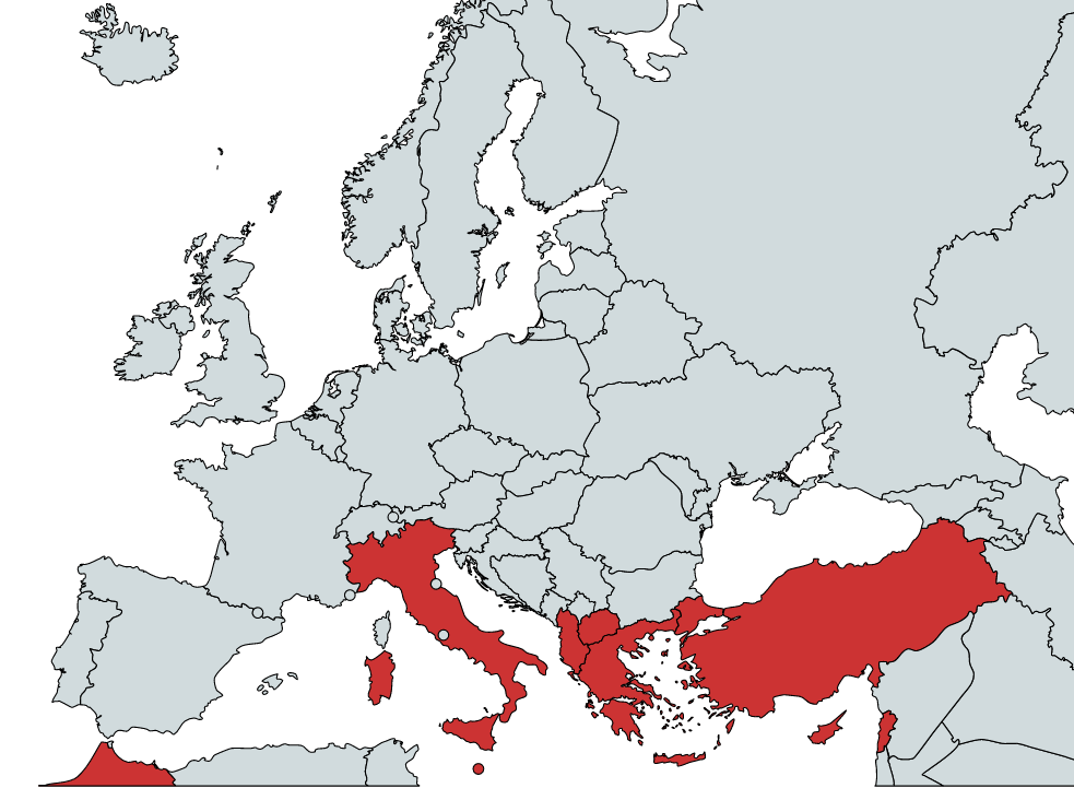 Occasionally one reads that climate change may benefit countries like Russia by delivering a longer growing season. However, this article from Geographical (UK) about the Russian Republic of Kalmykia, makes clear the issue is far more complex than that, especially as drought spreads on the steppe. geographical.co.uk/places/deserts/item/4101-the-republic-of-kalmykia-sits-at-the-forefront-of-global-climate-change-as-the-desert-encroaches
Heavy rainfall has led to devastating flooding in Germany, Belgium, and the Netherlands this week, primarily along the Rhine and the Meuse (French name)/Maas (Dutch/Flemish name) rivers and their tributaries. This map shows the rivers' watersheds (in black) with national boundaries shown in red.
www.researchgate.net/profile/Albrecht-Weerts/publication/320402299/figure/fig2/AS:551857768878080@1508584553526/Map-of-the-Meuse-and-Rhine-basins-and-the-forecasting-locations-that-are-considered-in.png Threatening Europe with refugees appears to be a new favorite ploy in international relations. Turkey has been using this tactic for more than five years, primarily focused on keeping Syrian refugees in Turkey in exchange for money and various other EU considerations. In May, Morocco allowed illegal migrants, primarily from Sub-Saharan Africa, to "escape" into adjacent Spanish territory to show displeasure with Spain's decision to provide medical treatment for a leader of Western Sahara's Polisario Front. Now Egypt is suggesting Europe may be faced with a flood of refugees (including "youth joining terrorist groups") if European countries do not side with Egypt in its dispute with Ethiopia over the filling of the Grand Ethiopian Renaissance Dam on a section of the Blue Nile in northwestern Ethiopia. www.al-monitor.com/originals/2021/07/egypt-warns-europe-against-illegal-immigration-amid-nile-dam-impasse
The primary case study in this New York Times article is Kobe, Japan, but the issues apply equally well to any coastal area in an earthquake zone, which includes much of the Philippines, Indonesia, Turkey, Greece, Italy, New Zealand, Chile, Mexico, the South Pacific, the Caribbean, and the U.S. Pacific coast, among many others: how does one build -- and pay for -- new sea walls that will not fail during the next earthquake? www.nytimes.com/2021/06/22/climate/san-francisco-sea-wall-earthquake.html
Although domestic tourism might be rebounding, the slow pace of vaccination in much of the world is expected to continue to depress international tourism. In fact, a recent UN report expects 2021 to be nearly as bad as 2020 in this regard, with estimates that global tourism will not return to pre-pandemic levels until 2023 or later. This geo-graphic shows the 10 countries that are expected to take the biggest hits to their economies in 2021 because of the lack of tourism. www.statista.com/chart/25202/gdp-losses-by-country-due-to-a-pandemic-related-reduction-in-tourism
Since the beginning of the civil war in neighboring Syria 10 years ago, Lebanon has hosted the largest number of externally displaced people on a per-capita basis. At one point, as many as one in four people in Lebanon were Syrian refugees. In 2020, the island of Aruba (technically part of the Netherlands) supplanted Lebanon as the host of the greatest per-capita number of externally displaced people, most of whom have fled nearby Venezuela. This geo-graphic, based on UN data, shows the eight countries hosting the most externally displaced people on a per-capita basis: www.statista.com/chart/3576/the-countries-with-the-most-refugees-per-capita
It remains to be seen if Europeans will be able to travel freely this summer. But if they can, this map shows the island destinations residents of European countries other than Russia have been Googling most over the last 24 months. Note: this map is in Spanish, which may require some translation of unfamiliar names (e.g., "Cerdeña" would be "Sardinia" in English). (Students in my geography classes learn that what Americans call a given country is frequently not what a country calls itself; this map is a reminder that place names in other languages are often different still.) www.traveler.es/experiencias/articulos/mapa-islas-europeas-preferidas-en-europa/21200
On the one hand, the number of Chinese millionaires increased by 22% between 2019 and 2020 according to Credit Suisse. But according to an AfrAsia Bank report, China also lost more millionaires than any other country in 2019, with 16,000 high net worth individuals (defined as having assets of $1-10 million) emigrating from China that year. Turkey, however, saw the greatest proportion of its high net worth individuals leave in 2019 (8%). Where did they go? Australia was the top destination for HNWIs in 2019, followed by the U.S. www.statista.com/chart/25007/hnwi-emigration-by-country
Earlier this week, the MV X-Press Pearl, bound for Colombo, Sri Lanka, caught fire and sank, releasing 78 tons of plastic pellets into the Indian Ocean, tens of millions of which are now covering Sri Lanka's beaches. The plastic pellets aboard the MV X-Press Pearl were to be used in the production of plastic bags. This geo-graphic looks at single-use plastic waste by country: www.statista.com/chart/24874/single-use-plastic-waste-generated-per-person-in-selected-countries
The encrypted messaging app WhatsApp has been in the news recently because Facebook, which bought the app in 2014, required users to accept new terms of service, including a new privacy policy, earlier this month. This geo-graphic shows where WhatsApp is most popular: www.statista.com/chart/24855/share-of-respondents-saying-they-regularly-use-whatsapp
Spain has two autonomous exclaves in North Africa: Melilla (on Morocco's northeastern coast) and Ceuta (on the Moroccan coast near Gibraltar). Ceuta was in the news this week when as many as 8,000 would-be migrants to the European Union, mostly from Sub-Saharan Africa, decided to swim from Morocco to Ceuta or climb the fence separating the two territories. Although Morocco normally polices the border to prevent that from happening, Moroccan officials apparently chose to express their displeasure with Spain's decision to admit the leader of Western Sahara's Polisario Front to a Spanish hospital by ... not. Most of the would-be migrants have since been sent back to Morocco.
ichef.bbci.co.uk/news/976/cpsprodpb/6D4E/production/_102028972_ceutamelilla9760618.png |
Blog sharing news about geography, philosophy, world affairs, and outside-the-box learning
Archives
December 2023
Categories
All
|
 RSS Feed